Cabonne Shire

Cabonne Shire
Shire of Cabonne
Australia-Map-NSW-LGA-Cabonne.png
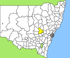
Lage des Cabonne Shire in New South Wales
Gliederung
Staat: Australien Australien
Bundesstaat: Flag of New South Wales.svg New South Wales
Verwaltungssitz: Molong
Daten und Zahlen
Fläche: 6.026 km²
Einwohner: 12.396 (2006) [1]
Bevölkerungsdichte: 2,1 Einwohner je km²
Wards: 6
-33.1148.85

Cabonne Shire ist ein lokales Verwaltungsgebiet (LGA) im australischen Bundesstaat New South Wales. Das Gebiet ist 6.026 km² groß und hat etwa 12.000 Einwohner.

Cabonne liegt in der Region Central West des Staates etwa 290 km westlich der Metropole Sydney und 285 km nördlich von Canberra. Das Gebiet umfasst 81 Ortsteile und Ortschaften, darunter Baldry, Boree, Cargo, Cudal, Cumnock, Manildra, Molong, Nashdale, Ophir, Toogong und Teile von Borenore, Canowindra, Eugowra, Spring Hill und Yeoval. Der Sitz des Shire Councils befindet sich in der Stadt Molong im Zentrum der LGA, wo etwa 2.100 Einwohner leben.

Cabonne Shire umschließt fast vollständig das Gebiet der LGA von Orange City.

Verwaltung

Der Cabonne Council hat 12 Mitglieder, die von den Bewohnern der sechs Wards gewählt werden (je zwei Councillor aus Goobang, Yuranigh, Canobolas, Belublua, Ophir und Nangar Ward). Diese sechs Bezirke sind unabhängig von den Ortschaften festgelegt. Aus dem Kreis der Councillor rekrutiert sich auch der Mayor (Bürgermeister) des Councils.

Weblinks

Einzelnachweise

  1. Australian Bureau of Statistics (25. Oktober 2007): Cabonne (A) (Local Government Area) (Englisch). 2006 Census QuickStats. Abgerufen am 6. April 2010.

Wikimedia Foundation.

Игры ⚽ Поможем написать реферат

Schlagen Sie auch in anderen Wörterbüchern nach:

  • Cabonne Shire Council — Infobox Australian Place | type = lga name = Cabonne state = nsw caption = Location in New South Wales pop = 11,864Census 2001 AUS|id=LGA11400|name=Cabonne (A) (Local Government Area)|accessdate=2007 06 30|quick=on] area = est = seat = Molong (99 …   Wikipedia

  • Cowra Shire — New South Wales Location in NSW Population: 12,945(2009) …   Wikipedia

  • Cowra Shire Council — Infobox Australian Place | type = lga name = Cowra Shire state = nsw caption = Location in NSW pop = 13,260Census 2001 AUS|id=LGA12350|name=Cowra (A) (Local Government Area)|accessdate=2007 06 30|quick=on] area = 2810 est = seat = Cowra (116… …   Wikipedia

  • Wakool Shire — Shire of Wakool New South Wales Location in New South Wales Population: 4,427(2009) …   Wikipedia

  • Blayney Shire Council — Infobox Australian Place | type = lga name = Blayney Shire state = nsw caption = Location in New South Wales pop = 6,120 Census 2001 AUS|id=LGA10850|name=Blayney (A) (Local Government Area)|accessdate=2007 06 30|quick=on] area = 1525 est = seat …   Wikipedia

  • Parkes Shire Council — Infobox Australian Place | type = lga name = Parkes Shire state = nsw caption = Location in New South Wales pop = 14,433Census 2001 AUS|id=LGA16200|name=Parkes (A) (Local Government Area)|accessdate=2007 06 30|quick=on] area = 5958 est = seat =… …   Wikipedia

  • Forbes Shire Council — Infobox Australian Place | type = lga name = Forbes Shire state = nsw caption = Location in New South Wales pop = 9,691 Census 2001 AUS|id=LGA12900|name=Forbes (A) (Local Government Area)|accessdate=2007 06 30|quick=on] area = 4720 est = seat =… …   Wikipedia

  • Narromine Shire — Narromine New South Wales Location in New South Wales Population: 6,818(2009) …   Wikipedia

  • Muswellbrook Shire — New South Wales Location in New South Wales Population …   Wikipedia

  • Conargo Shire — New South Wales Location in New South Wales Population: 1,700(2009) …   Wikipedia

Share the article and excerpts

Direct link
Do a right-click on the link above
and select “Copy Link”