- Ave (Subregion)
-
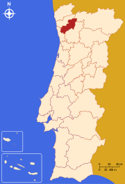
Lage von AveDie Region Ave ist eine statistische portugiesische Subregion und Teil der Região Norte. Während die Mehrzahl der Kreise zum Distrikt Braga gehören, sind Santo Tirso und Trofa dem Distrikt Porto zugeordnet. Im Norden grenzt Ave an Cávado und Alto Trás-os-Montes, im Osten und Süden an Tâmega und im Westen an Grande Porto. Fläche: 1238 km². Einwohner (2001): 509.969. Der Subregion sind die folgenden Kreise (concelhos) zugeordnet:

Região Norte (8): Alto Trás-os-Montes | Ave | Cávado | Douro | Entre Douro e Vouga | Grande Porto | Minho-Lima | Tâmega
Região Centro (12): Baixo Mondego | Baixo Vouga | Beira Interior Norte | Beira Interior Sul | Cova da Beira | Dão-Lafões | Médio Tejo | Oeste | Pinhal Interior Norte | Pinhal Interior Sul | Pinhal Litoral | Serra da Estrela
Região de Lisboa (2): Grande Lisboa | Península de Setúbal
Alentejo (5): Alentejo Central | Alentejo Litoral | Alto Alentejo | Baixo Alentejo | Lezíria do Tejo
Algarve (1): Algarve
Wikimedia Foundation.
Schlagen Sie auch in anderen Wörterbüchern nach:
Ave (subregión) — Saltar a navegación, búsqueda Ave Región de Portugal Mapa … Wikipedia Español
Ave, Subregion — Ave is a subregion integrated in the larger Norte region in Portugal. Is bordered to the north by the subregion of Cávado, to the east and south by the subregion of Tâmega and to the west by the subregion of Grande Porto. It is a densely… … Wikipedia
Ave — bezeichnet: Ave (Fluss) in Portugal Riba de Ave, Stadt am Fluss Ave Ave (Subregion), Teil der portugiesischen Região Norte einen Ortsteil der Stadt Penzlin mit dem Aver See im Landkreis Mecklenburgische Seenplatte in Mecklenburg Vorpommern Ave… … Deutsch Wikipedia
Ave (desambiguación) — El término Ave puede referirse a: Ave, clase de animales. Ave, antiguo saludo romano. Ave, río de Portugal. Ave, subregión estadística portuguesa que toma su nombre del río anterior. Idioma avéstico, por su código ISO 639 2 y 639 3. El acrónimo… … Wikipedia Español
AVE (disambiguation) — AVE could refer to:* Advanced Vehicle Engineers * African American Vernacular English * Alta Velocidad Española, a high speed train used in Spain * Avestan language (ISO 639 alpha 3, ave) * Ave. is an abbreviation for avenue; see also road. * Ave … Wikipedia
Cávado Subregion — Map showing the location of the Cávado subregion Cávado is a subregion that is integrated in the Portuguese region of Norte. It has 6 municipalities or Concelhos (in Portuguese) and is centered in the city of Braga (pop. 153,000). With an area of … Wikipedia
Minho-Lima Subregion — Map showing the location of the Minho Lima subregion Minho Lima is a Portuguese NUTS3 subregion, belonging to Norte Region, between the Minho River and Lima River in the northern part of Portugal. It corresponds to the historical region of Alto… … Wikipedia
Tâmega (Subregion) — Lagekarte von Tâmega Tâmega ist eine statistische Subregion Portugals und Teil der Região Norte. Sie wurde nach dem gleichnamigen Fluss benannt. Zum größten Teil besteht sie aus Gebieten des Distriktes Porto und wird durch einzelne Kreise der… … Deutsch Wikipedia
Grande Porto Subregion — Map showing the location of the Grande Porto subregion Grande Porto or Greater Porto is a Portuguese NUTS3 subregion, integrating the NUTS2 region of Norte, in Portugal. It corresponds to 11 municipalities out of 16, the other 5 in Entre Douro e… … Wikipedia
Douro (Subregion) — Lagekarte der Subregion Douro Douro ist eine statistische Subregion Portugals. Sie ist Teil der Região Norte, und setzt sich aus Kreisen der Distrikte Bragança, Vila Real, Viseu und Guarda zusammen. Im Norden grenzt die Subregion Alto Trás os… … Deutsch Wikipedia
Ave (Subregion)

18+
© Academic, 2000-2024
- Kontaktieren Sie uns: Unterstützung, Werbung
Wörterbücher Export, schritte mit PHP, Joomla, Drupal, WordPress, MODx.