Arizona State Route 238

Arizona State Route 238
Straßenschild der Arizona State Route 238
Karte
Karte der Arizona State Route 238
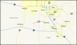
Basisdaten
Gesamtlänge:  20,27 mi/32,62 km
Eröffnung:  1986
Anfangspunkt:  Nahe Mobile
Endpunkt:  Arizona 347.svg AZ 347 in Maricopa
Countys:  Maricopa County
Pinal County

Die Arizona State Route 238 (kurz AZ 238) ist eine State Route im US-Bundesstaat Arizona, die in Ost-West-Richtung verläuft.

Die State Route beginnt nahe Mobile und endet nach 33 Kilometern im Norden von Maricopa an der Arizona State Route 347. Etwa auf der Hälfte der Strecke passiert die AZ 238 den Estrella Sailport. Die Straße folgt der Linie der Southern Pacific Railroad zwischen Maricopa und Gila Bend. Der Abschnitt westlich der AZ 238 gehört offiziell nicht zum State Route System und wird als Maricopa County Road 238 bezeichnet.

Die Straße wurde im Jahr 1986 zur Arizona State Route erklärt und sollte als Anbindung an eine geplante Müllverbrennungsanlage dienen.[1] Die Asphaltierung der gesamten Verbindung zwischen Maricopa und Gila Brend wurde in den späten 1990er Jahren abgeschlossen.

Siehe auch

Quellen

  1. Arizona Roads: AZ 238, aufgerufen am 23. Juli 2010

Weblinks


Wikimedia Foundation.

Игры ⚽ Поможем сделать НИР

Schlagen Sie auch in anderen Wörterbüchern nach:

  • Arizona State Route 238 — Infobox road marker state=AZ highway name= name notes= type=state route=238 alternate name= maint= length mi=20.27 length round=2 length ref=cite web |url=http://tpd.az.gov/data/reports/2006SHSLog.pdf |title=2006 ADOT Highway Log |author=Arizona… …   Wikipedia

  • Arizona State Route 347 — Karte …   Deutsch Wikipedia

  • Arizona State Route 260 — Infobox road marker state=AZ highway name= name notes= type=state route=260 alternate name= maint= length mi=217.78 length round=2 length ref=cite web |url=http://tpd.az.gov/data/reports/2006SHSLog.pdf |title=2006 ADOT Highway Log |author=Arizona …   Wikipedia

  • Arizona State Route 210 — Infobox road marker state=AZ highway name= name notes= type=state route=210 alternate name= maint= length mi=3.96 length round=2 length ref=cite web |url=http://tpd.az.gov/data/reports/2006SHSLog.pdf |title=2006 ADOT Highway Log |author=Arizona… …   Wikipedia

  • Arizona State Route 347 — Infobox road marker state=AZ highway name= name notes= type=state route=347 alternate name= maint= length mi=28.50 length round=2 length ref=cite web |url=http://tpd.az.gov/data/reports/2006SHSLog.pdf |title=2006 ADOT Highway Log |author=Arizona… …   Wikipedia

  • Utah State Route 252 — Infobox road state=UT type=SR route=252 section=131 maint=UDOT length mi=6.755 length round=3 length ref=cite web | title=State Route 252 Highway reference | publisher=Utah Department of Transportation | url=http://www.dot.utah.gov/main/uconowner …   Wikipedia

  • Interstate 210 and State Route 210 (California) — Interstate 210, State Route 210 Foothill Freeway …   Wikipedia

  • List of highways numbered 238 — The following highways are numbered 238: Canada Newfoundland and Labrador Route 238 United States Interstate 238 Arizona State Route 238 (former) …   Wikipedia

  • Maricopa, Arizona — This is about the city. For the county, see Maricopa County City of Maricopa, Arizona   City   Residential developments dominate the landscape of Maricopa …   Wikipedia

  • Mobile (Arizona) — Mobile Lage im County und in Arizona Basisdaten …   Deutsch Wikipedia

Share the article and excerpts

Direct link
Do a right-click on the link above
and select “Copy Link”