- Burnley (Borough)
-
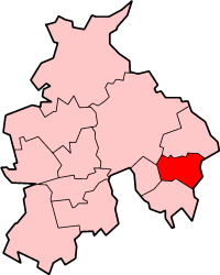
Borough of Burnley 
Lage in LancashireStatus Borough Region North West England Verw.grafschaft Lancashire Verwaltungssitz Burnley Fläche 110,70 km² (233.) Einwohner 87.500 (272.) ONS-Code 30UD Website www.burnley.gov.uk Burnley ist ein Verwaltungsbezirk mit dem Status eines Borough in der Grafschaft Lancashire in England. Verwaltungssitz ist die gleichnamige Stadt Burnley, in der mehr als vier Fünftel der Bevölkerung lebt. Darüber hinaus umfasst der Bezirk mehrere Dörfer, von denen Padiham das größte ist. Burnley ist eine Hochburg der rechtsextremen British National Party.
Der Bezirk wurde am 1. April 1974 gebildet und entstand aus der Fusion des ehemaligen County Borough Burnley und des Rural District Burnley.
Weblinks
 Commons: Burnley – Sammlung von Bildern, Videos und Audiodateien
Burnley | Chorley | Fylde | Hyndburn | Lancaster | Pendle | Preston | Ribble Valley | Rossendale | South Ribble | West Lancashire | Wyre
Wikimedia Foundation.
Schlagen Sie auch in anderen Wörterbüchern nach:
Burnley (borough) — Infobox UK District name = Borough of Burnley status = Borough region = North West England admincounty = Lancashire area = Ranked 233rd 110.70 km² adminhq = Burnley onscode = 30UD population = Ranked English district rank|ONS=30UD English… … Wikipedia
Burnley (Begriffsklärung) — Burnley ist der Name einer Stadt in England; siehe Burnley eines Borough in England; siehe Burnley (Borough) eines Wahlbezirkes in England; siehe Burnley (Wahlkreis) des Vereins FC Burnley einer Stadt in Australien; siehe Burnley (Australien) des … Deutsch Wikipedia
Burnley — Burnley … Wikipédia en Français
Burnley — Saltar a navegación, búsqueda Burnley es una ciudad en la zona metropolitana de Burnley en Lancashire, Inglaterra, con una población de alrededor de 73.500 habitantes. Se encuentra a 18 km al este de Blackburn y a 40 de Preston, en la confluencia … Wikipedia Español
Burnley — Koordinaten 53° 47′ N, 2° 15′ W … Deutsch Wikipedia
Burnley Wood — is a district of Burnley, Lancashire. In broad terms it lies between Parliament Street in the north and Stoney Street in the south, and from the railway in the west to Todmorden Road in the east.History. [http://www.burnley.gov.uk/downloads/BWood … Wikipedia
Burnley — For the larger local government district, see Burnley (borough). For other meanings see Burnley (disambiguation) Coordinates: 53°47′20″N 2°14′53″W / … Wikipedia
Burnley Mechanics — Coordinates: 53°47′16″N 2°14′40″W / 53.7878°N 2.2445°W / 53.7878; 2.2445 … Wikipedia
Burnley Manchester Road railway station — Infobox UK station name = Burnley Manchester Road manager = Northern Rail locale = Burnley borough = Burnley years = 1866 1961 September 1986 events = Opened Closed Reopened platforms = 2 lowusage0405 = 143,181 lowusage0506 = 151,216 lowusage0607 … Wikipedia
Burnley Central railway station — Infobox UK station name = Burnley Central code = BNC manager = Northern Rail locale = Burnley borough = Burnley years = 1849 1870 1944 1964 events = Opened (1 February) Renamed Burnley Bank Top Reverted to Burnley Central Rebuilt platforms = 1… … Wikipedia
Burnley (Borough)
18+
© Academic, 2000-2024
- Kontaktieren Sie uns: Unterstützung, Werbung
Wörterbücher Export, schritte mit PHP, Joomla, Drupal, WordPress, MODx.