- Broxbourne (Borough)
-
Borough of Broxbourne 
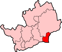
Lage in HertfordshireStatus Borough Region East of England Verw.grafschaft Hertfordshire Verwaltungssitz Cheshunt Fläche 51,43 km² (297.) Einwohner 89.500 (264.) ONS-Code 26UB Website www.broxbourne.gov.uk Broxbourne ist ein Verwaltungsbezirk mit dem Status eines Borough in der Grafschaft Hertfordshire in England. Im Süden grenzt er an Greater London, im Osten an den Fluss Lea. Verwaltungssitz ist Cheshunt.
Der Bezirk wurde am 1. April 1974 gebildet und entstand aus der Fusion der Urban Districts Cheshunt und Hoddesdon.
Orte im Borough
- Broxbourne
- Cheshunt
- Goff's Oak
- Hoddesdon
- Waltham Cross
Broxbourne | Dacorum | East Hertfordshire | Hertsmere | North Hertfordshire | St Albans | Stevenage | Three Rivers | Watford | Welwyn Hatfield
Wikimedia Foundation.
Schlagen Sie auch in anderen Wörterbüchern nach:
Broxbourne (borough) — For the town, see Broxbourne .Broxbourne is a local government district and borough in Hertfordshire, England. Its council is based in Cheshunt, other towns include Broxbourne, Hoddesdon and Waltham Cross. The eastern boundary of the district is… … Wikipedia
Broxbourne Borough V. & E. F.C. — Football club infobox clubname = Broxbourne Borough Victoria Elm fullname = Broxborune Borough Victoria Elm Football Club nickname = Boro founded = 1991 (as Somersett Ambury Victoria Elm) ground = Goffs Lane, Broxbourne capacity = 5,000 chairman … Wikipedia
Broxbourne Borough Council — is the local authority for the Broxbourne non metropolitan district of England, the United Kingdom. Broxbourne is located in the south east of Hertfordshire, in the East of England region. The Council itself is based in Cheshunt, the largest… … Wikipedia
Broxbourne — infobox UK place country = England latitude= 51.7495 longitude= 0.0216 official name= Broxbourne population = 13,298 shire district= Broxbourne shire county = Hertfordshire region= East of England constituency westminster= Broxbourne post town=… … Wikipedia
Broxbourne railway station — Infobox UK station name = Broxbourne code = BXB manager = National Express East Anglia locale = Broxbourne borough = Broxbourne (borough) usage0405 = 1.367 usage0506 = 1.335 usage0607 = 1.394 platforms = 4 start = 1840WA CambridgeBroxbourne… … Wikipedia
Broxbourne local elections — One third of Broxbourne Borough Council is elected each year, followed by one year without election.Political controlConservative 1973 presentCouncil electionsBroxbourne Council election, 1998Broxbourne Council election, 1999Broxbourne Council… … Wikipedia
Broxbourne (UK Parliament constituency) — UK constituency infobox Name = Broxbourne Map1 = Broxbourne Map2 = Hertfordshire Type = Borough Year = 1983 Entity = Hertfordshire County = Hertfordshire EP = East of England MP = Charles Walker Party = ConservativeBroxbourne is a parliamentary… … Wikipedia
Broxbourne — ▪ district, England, United Kingdom borough (district), administrative and historic county of Hertfordshire, England. The borough comprises the valley of the River Lea (a tributary of the Thames), which flows from north to south along its… … Universalium
Broxbourne White Water Canoe Centre — The Broxbourne White Water Canoe Centre is the planned venue for the slalom canoeing and slalom kayaking events in the 2012 Summer Olympics.VenueThe venue is to be built near the town of Waltham Cross, but named after the borough of Broxbourne,… … Wikipedia
Chelmsford (borough) — Borough of Chelmsford Non metropolitan district, Borough Chelmsford shown within Essex … Wikipedia
Broxbourne (Borough)
18+
© Academic, 2000-2024
- Kontaktieren Sie uns: Unterstützung, Werbung
Wörterbücher Export, schritte mit PHP, Joomla, Drupal, WordPress, MODx.