- Brindabella Ranges
-
Brindabella Ranges 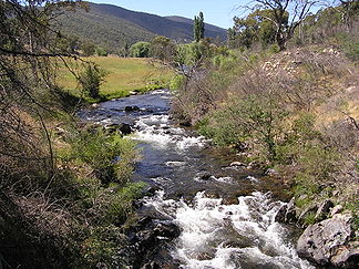
Goodradigbee River im Brindabella Valley
Lage New South Wales, Australian Capital Territory (Australien) Teil der Snowy Mountains 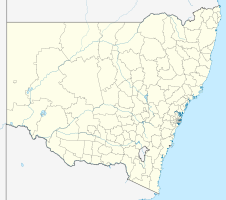

Koordinaten 35° 33′ S, 148° 46′ O-35.55148.76666666667Koordinaten: 35° 33′ S, 148° 46′ O Die Brindabella Ranges sind eine Bergkette in New South Wales in Australien. Sie liegen rund 40 km südwestlich der Hauptstadt Canberra und bilden einen Teil der Snowy Mountains. Durch das Brindabella Valley in der Mitte der Bergkette fließt der Goodradigbee River.
Der Name Brindabella soll in der Sprache der lokalen Aborigines „zwei Känguruhratten“ bedeuten. Allerdings gibt eine andere Quelle an, dass „Brindy brindy“ ein lokaler Ausdruck für über Felsen fließendes Wasser sei. Der Zusatz „bella“ sei von den Europäern hinzugefügt worden, bedeutungsgleich mit „bella vista“ („schöne Aussicht“).
Vor der europäischen Besiedlung war die Bergkette von den Stämmen der Ngunawal, Walgalu und Djimantan besiedelt. Europäische Schafzüchter ließen sich hier erstmals in den 1830er Jahren nieder, der erste Landkauf erfolgte 1849. Gold wurde im Jahr 1860 gefunden, jedoch erst ab Mitte der 1880er Jahre abgebaut. Die Brindabella-Goldminengesellschaft wurde 1887 gegründet und war bis 1910 tätig. Heute wird die Gegend landwirtschaftlich genutzt.
Die australische Schriftstellerin Miles Franklin wuchs im Brindabella Valley auf und schrieb das autobiografische Werk „Childhood at Brindabella“, das von ihrer Kindheit im Tal erzählt.
Kategorien:- Gebirge in Australien und Ozeanien
- Gebirge in Australien


Wikimedia Foundation.