- Bridgnorth (District)
-
Bridgnorth District 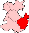
Lage in ShropshireStatus District Region West Midlands Verw.grafschaft Shropshire Verwaltungssitz Bridgnorth Fläche 633,17 km² (70.) Einwohner 51.800 (340.) ONS-Code 39UB Website - Gründung 1974 Auflösung 2009 Bridgnorth war ein District in der Grafschaft Shropshire in England. Verwaltungssitz war die gleichnamige Stadt Bridgnorth. Der District umfasste auch die Orte Albrighton, Broseley, Much Wenlock und Shifnal.
Der Bezirk wurde am 1. April 1974 gebildet und entstand aus der Fusion des Rural District Bridgnorth und fast des gesamten Rural District Shifnal. Am 1. April 2009 wurde er aufgrund einer Gebiets- und Verwaltungsreform aufgelöst und ging in der neuen Unitary Authority Shropshire auf.
Kategorien:- Ehemaliger District (West Midlands)
- Shropshire

Wikimedia Foundation.