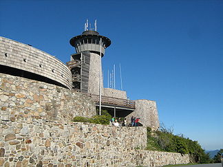
Brasstown Bald — Infobox Mountain Name = Brasstown Bald (Enotah) Photo = Brasstown Bald observation tower.jpg Caption = Observation tower atop Brasstown Bald Elevation = 4,784 feet (1,458 m) Location = Georgia, United States Range = Blue Ridge Mountains… … Wikipedia
Brasstown Bald — Sp Brãstauno kálnas Ap Brasstown Bald Sp Meškėnų kálnas Ap Mount Enotah L Mėlynajame klng., JAV (Džordžija) … Pasaulio vietovardžiai. Internetinė duomenų bazė
Brasstown Bald — ▪ mountain, Georgia, United States formerly Mount Enotah highest point in Georgia, U.S., reaching an elevation of 4,784 feet (1,458 metres). It lies in the northwest part of the state in the Blue Ridge Mountains, 9 miles (14 km) east of… … Universalium
Brasstown — may mean:*Brasstown, Georgia, for which Brasstown Bald was named *Brasstown, North Carolina, located in Clay County, North Carolina on the North Carolina Georgia border. *Brasstown, South Carolina … Wikipedia
Bald — ist der Familienname folgender Personen: Detlef Bald (* 1941), deutscher Historiker, Politikwissenschaftler und Publizist Marion Bald, deutsche Biathletin Bald ist der Name folgender geografischer Objekte: Brasstown Bald, Berg in Georgia, USA… … Deutsch Wikipedia
Brasstown Wilderness — The Brasstown Wilderness was designated in 1986 and currently consists of 12,896 acres (52.2 km²). The Wilderness is located within the borders of the Chattahoochee National Forest in Towns County, Georgia. The Wilderness is managed by the United … Wikipedia
Brasstown Ranger District — The Brasstown Ranger District is one of the five ranger districts of the Chattahoochee National Forest. The district includes land located in Lumpkin, Towns and Union counties, Georgia. Comprising approximately convert|157000|acre|km2, the… … Wikipedia
Rabun Bald — Rabun Bald, with an elevation of 4,696 feet is the second highest peak in Georgia; only Brasstown Bald (4,784 feet) is higher. It is located in Rabun County, Georgia and is the tallest mountain in the county. An observation tower on the summit… … Wikipedia
Rocky Knob (Georgia) — For other peaks or mountains called Rocky Knob, see Rocky Knob. For other mountains named Rocky Mountain, see Rocky Mountain Rocky Knob is a name used to describe eight different mountain peaks located in the North Georgia mountains that are… … Wikipedia
Geography of Georgia (U.S. state) — The geography of Georgia describes a state in the Southeastern United States in North America. The Golden Isles of Georgia lie off the coast of the state. The main geographical features include mountains such as the Ridge and valley Appalachians… … Wikipedia