Bombala Council

Bombala Council
Bombala Council
Australia-Map-NSW-LGA-Bombala.png
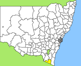
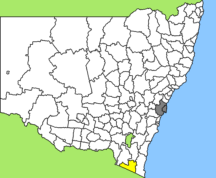
Lage des Bombala Council in New South Wales
Gliederung
Staat: Australien Australien
Bundesstaat: Flag of New South Wales.svg New South Wales
Verwaltungssitz: Bombala
Daten und Zahlen
Fläche: 3.944 km²
Einwohner: 2.541 (2006) [1]
Bevölkerungsdichte: 0,6 Einwohner je km²
-36.916666666667149.23333333333

Bombala Council ist ein lokales Verwaltungsgebiet (LGA) im australischen Bundesstaat New South Wales. Das Gebiet ist 3.944 km² groß und hat etwa 2.500 Einwohner.

Bombala liegt im äußersten Südosten des Staates an der Grenze zu Victoria etwa 200 km südlich der australischen Hauptstadt Canberra und 540 km nordöstlich von Melbourne. Das Gebiet umfasst 67 Ortsteile und Ortschaften, darunter Ando, Bibbenluke, Bombala, Cathcart, Cooma, Corrowong, Craigie, Delegate, Maharatta und Rockton. Der Verwaltungssitz des Councils befindet sich in der Stadt Bombala im Osten der LGA, wo etwa 1.200 Einwohner leben.

Bombala nennt sich auch "Platypus Country", die Heimat des Schnabeltiers.

Verwaltung

Der Council von Bombala hat neun Mitglieder, die von den Bewohnern der LGA gewählt werden. Bombala ist nicht in Bezirke untergliedert. Aus dem Kreis der Councillor rekrutiert sich auch der Mayor (Bürgermeister) des Councils.

Weblinks

Einzelnachweise

  1. Australian Bureau of Statistics (25. Oktober 2007): Bombala (A) (Local Government Area) (Englisch). 2006 Census QuickStats. Abgerufen am 6. April 2010.

Wikimedia Foundation.

Игры ⚽ Поможем написать курсовую

Schlagen Sie auch in anderen Wörterbüchern nach:

  • Bombala Council — Infobox Australian Place | type = lga name = Bombala Council state = nsw caption = Location in NSW region=Monaro area=3945 seat=Bombala (71 Caveat Street)cite web title=Bombala Council publisher = Department of Local Government url =… …   Wikipedia

  • Bombala, New South Wales — Infobox Australian Place | type = town name = Bombala state = nsw caption = Bombala lga = Bombala Council postcode = 2632 est = pop = 2,222 elevation= 761 maxtemp = 17.8 mintemp = 5.1 rainfall = 496.9 stategov = Monaro fedgov = Eden Monaro dist1 …   Wikipedia

  • Marrickville Council — New South Wales Population: 78,271(2009) …   Wikipedia

  • Burwood Council — New South Wales Population: 33,803(2009) …   Wikipedia

  • Manly Council — New South Wales Population: 40 …   Wikipedia

  • North Sydney Council — New South Wales Population: 63,914(2009) …   Wikipedia

  • Clarence Valley Council — Clarence Valley New South Wales Location in New South Wales Population …   Wikipedia

  • Deniliquin Council — New South Wales Population: 7,693(2009) …   Wikipedia

  • Bega Valley Shire Council — Infobox Australian Place | type = lga name = Bega Valley state = nsw caption = Location in NSW region=South Coast area=6280 seat=Bega (Zingel Place)cite web title=Bega Valley Shire Council publisher = Department of Local Government url =… …   Wikipedia

  • Mid-Western Regional Council — Mid Western Regional New South Wales Location in New South Wales Population …   Wikipedia

Share the article and excerpts

Direct link
Do a right-click on the link above
and select “Copy Link”