Blue Mesa Reservoir

Blue Mesa Reservoir
Blue Mesa Reservoir
Blick auf das Blue Mesa Reservoir mit den West Elk Mountains im Hintergrund
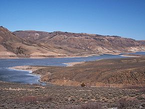
Lage: Südl. Rocky Mountains, Colorado, USA
Zuflüsse: Gunnison, Cebolla Creek, Lake Fork (Colorado)
Größere Orte in der Nähe: Sapinero, Gunnison
Blue Mesa Reservoir (Colorado)
Blue Mesa Reservoir
Koordinaten 38° 27′ 0″ N, 107° 20′ 0″ W38.45-107.33333333333Koordinaten: 38° 27′ 0″ N, 107° 20′ 0″ W
Daten zum Bauwerk
Bauzeit: -1965
Höhe des Absperrbauwerks: 119 mdep1
Bauwerksvolumen: 2,35 Mio m³dep1
Kronenlänge: 240 mdep1
Kraftwerksleistung: 60 MWdep1
Daten zum Stausee
Höhe des Stauziels: 2.295 m
Wasseroberfläche bei Vollstau: 37 km²dep1
Stauseelänge: 32 kmdep1
Speicherraum: 0,923 km³dep1
Gesamtstauraum: 1,16 km³dep1
Bluemesa.JPG
Frühsommer am Stausee - im Hintergrund die Brücke des US-Highway 50

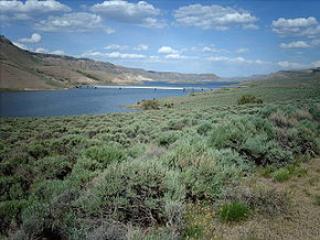
Das Blue Mesa Reservoir ist der größte Stausee des US-Bundesstaates Colorado.

Das Blue Mesa Reservoir liegt im südwestlichen Colorado zwischen den West Elk Mountains und dem San-Juan-Gebirge im Gunnison County. Der See wird vom 1965 errichteten Blue-Mesa-Staudamm aufgestaut und überflutet den Großteil der ehemals 80 km langen Gunnison-Schlucht, deren verbliebener Teil im Westen (Black Canyon) im Jahr 1999 unter den staatlichen Schutz eines Nationalparks gestellt wurde.

Der Stausee ist 32 Kilometer lang und hat eine Küstenlänge von 154 Kilometer. Die maximale Speicherkapazität beträgt 1,16 Mrd. (1,16 km³) bei einer maximalen Tiefe von 113 m.

Wie viele andere Stauseen dient er zur Energiegewinnung, dem Hochwasserschutz, der Bewässerung sowie als Naherholungsgebiet. Der See ist Teil des Erholungsgebiets Curecanti, das unter der Verwaltung des National Park Service steht. Für die lokale Bevölkerung ist das Blue Mesa Reservoir ein beliebtes Angel- und Wassersportzentrum.

Weblinks


Wikimedia Foundation.

Игры ⚽ Нужен реферат?

Schlagen Sie auch in anderen Wörterbüchern nach:

  • Blue Mesa Reservoir — Infobox lake lake name = Blue Mesa Reservoir image lake = Bluemesa.jpg caption lake = image bathymetry = caption bathymetry = location = Gunnison County, Colorado coords = coord|38|27|N|107|20|W|type:waterbody region:US CO|display=inline,title… …   Wikipedia

  • Blue Mesa Reservoir — Sp Mėlynojo Stálkalnio tvenkinỹs Ap Blue Mesa Reservoir L JAV (Koloradas) …   Pasaulio vietovardžiai. Internetinė duomenų bazė

  • Blue Mesa Dam — is a 390 foot tall earthen dam on the Gunnison River located in Colorado. It creates Blue Mesa Reservoir, and is within Curecanti National Recreation Area. Colorado State Route 92 passes over the top of the dam. The dam is upstream of the Morrow… …   Wikipedia

  • Morrow Point Reservoir — is an artificial reservoir on the Gunnison River in southwestern Colorado operated by the U.S. Bureau of Reclamation. Located in the upper Black Canyon of the Gunnison, it is impounded by 468 foot tall (143 m) tall Morrow Point Dam, and is… …   Wikipedia

  • Crystal Reservoir — is an artificial reservoir on the Gunnison River in southwestern Colorado operated by the U.S. Bureau of Reclamation. Located in the upper Black Canyon of the Gunnison, it is impounded by 323 foot tall (98 m) tall Crystal Dam, and is within… …   Wikipedia

  • Mountain Mesa, California — Mountain Mesa   census designated place   Mountain Mesa viewed from across Lake Isabella …   Wikipedia

  • Curecanti National Recreation Area — IUCN Category V (Protected Landscape/Seascape) …   Wikipedia

  • Colorado River Storage Project — Glen Canyon Dam and Lake Powell near Page, Arizona. The dam and lake are major components in the Colorado River Storage Project s attempt to regulate the flow of the Colorado River. The Colorado River Storage Project is a United States Bureau of… …   Wikipedia

  • List of dams and reservoirs in the United States — This list is incomplete; you can help by expanding it. The following is a partial list of dams and reservoirs in the United States. There are an estimated 75,000 dams in the United States, impounding 600,000 mi (970,000 km) of river or about 17%… …   Wikipedia

  • Navajo Dam — Daʼdeestłʼin (Navajo) View of Navajo Dam from the air Country United States …   Wikipedia

Share the article and excerpts

Direct link
Do a right-click on the link above
and select “Copy Link”