- Black River (Mauritius)
-
Basisdaten Bezirkshauptstadt: Bambous Fläche: 7154,23 km² Einwohner: 60.587 (2000) Bevölkerungsdichte: 223,93 Einwohner/km² Offizielle Webseite ISO 3166-2 code MU-BL Lage in Mauritius 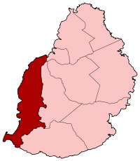
Black River ist ein Bezirk von Mauritius auf der Westseite der Insel. Eine Touristenattraktion sind die Tamarin-Fälle. Die Bezirkshauptstadt ist Bambous. Davor war es Tamarin. Seiner Fläche nach ist es der drittgrößte Bezirk von Mauritius, aber der kleinste in Bezug auf die Bevölkerung. Das Gebiet besticht durch seine auf Mauritius einzigartigen tropischen Wälder, einschließlich derjenigen am Black-River-Pass.
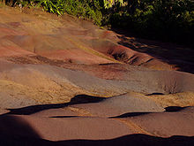 Terres des Couleurs im Südwesten von Mauritius
Tourismus
Inzwischen sind mehrere Fischerdörfer wie Flic-en-Flac, Tamarin und Le Morne zu touristischen Orten umgewandelt worden. Tamarin ist das einzige Gebiet, in dem das Surfen während der Monate Juli und August möglich ist. Flic-en-Flac besitzt den längsten Strand der Insel. Le Morne gelangte zu trauriger Berühmtheit, als sich während der Kolonialzeit entflohene Sklaven zunächst am benachbarten Berg versteckten und schließlich wegen fehlender Fluchtmöglichkeit Suizid begingen.
Le Morne ist heute ein beliebtes Gebiet für Kite- und Windsurfer.
Weblinks

Distrikte: Black River | Flacq | Grand Port | Moka | Pamplemousses | Plaines Wilhems | Port Louis (Distrikt) | Riviere du Rempart | Savanne
Städte: Beau Bassin-Rose Hill | Curepipe | Port Louis (Stadt) | Quatre Bornes | Vacoas-Phoenix
Abhängige Inseln : Agalega | Cargados Carajos | Rodrigues
Wikimedia Foundation.
Schlagen Sie auch in anderen Wörterbüchern nach:
Black River — (wörtlich übersetzt: „Schwarzer Fluss“) ist der Name zahlreicher Flüsse, Orte und Filme: Flüsse: in den USA: Black River (Alcona County) im Bundesstaat Michigan Black River (Cheboygan County) im Bundesstaat Michigan Black River (Allegan County)… … Deutsch Wikipedia
Black River — is a common name for streams and communities around the world, as well as the Spanish and Portuguese translation for Rio Negro .treamsAfrica*Bafing River is called the Black River.Canada*Black River (New Brunswick) *Black River (Newfoundland and… … Wikipedia
Black River Gorges National Park — is a national park in the hilly south western part of Mauritius. It was proclaimed on June 15 1994 and is managed by the National Parks and Conservation Service. It covers an area of 67.54 km² including humid upland forest, drier lowland forest… … Wikipedia
Black River (district) — Infobox Dist and Dep MU name=Black River District capital=Tamarin population=60,587 population as of=2000 pop rank=N/A area=259 area rank=N/A pop dens=223.93 places=N/A area code=N/A ISO=MU BL Black River is a district of Mauritius on the western … Wikipedia
Mauritius Kestrel — Conservation status Vulnerable (IUCN 3 … Wikipedia
Mauritius Olive White-eye — Conservation status Critically Endangere … Wikipedia
Mauritius-Brillenvogel — (Zosterops chloronothos) Systematik Ordnung: Sperlingsvögel (Passeriformes) Un … Deutsch Wikipedia
Mauritius — Mauritian, adj. /maw rish euhs, rish ee euhs/, n. 1. an island in the Indian Ocean, E of Madagascar. 880,781; 720 sq. mi. (1865 sq. km). 2. a republic consisting of this island and dependencies: formerly a British colony. 1,154,272; 809 sq. mi.… … Universalium
Mauritius — Republic of Mauritius Republik Mauritius … Deutsch Wikipedia
Mauritius — For other uses, see Mauritius (disambiguation). Not to be confused with Mauritania. Coordinates … Wikipedia
Black River (Mauritius)


18+
© Academic, 2000-2024
- Kontaktieren Sie uns: Unterstützung, Werbung
Wörterbücher Export, schritte mit PHP, Joomla, Drupal, WordPress, MODx.