- Berry Islands
-
Berry Islands Strand auf den Berry Islands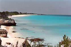
Gewässer Atlantischer Ozean Archipel Bahamas Geographische Lage 25° 35′ N, 77° 55′ W25.582-77.915Koordinaten: 25° 35′ N, 77° 55′ W 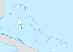

Anzahl der Inseln 30 Hauptinsel Great Harbour Cay Gesamtfläche 78 km² Die Berry Islands sind eine zu den Bahamas gehörende Inselkette. Die im Nordwesten des Einzugsgebiets der Bahamas gelegene Inselgruppe erstreckt sich über rund 78 km². Der Archipel besteht aus über 30 Inseln und weiteren 100 kleinen Cays. Die größte Insel der Berry Islands ist mit etwa 31 km² Landfläche Great Harbour Cay, auf welcher sich auch die größte Siedlung der Inseln, Bullock´s Harbour, befindet. In dem Hafenort leben heute etwa 300 Menschen. Die Berry Islands wurden zuerst von den Tumoroks und den Libayan-Indianern bewohnt, die im 16. Jahrhundert ausstarben. Die Inseln waren in Folge bis ins 17. Jahrhundert unbewohnt. Dazwischen wurden die Berry Islands von Piraten als Versteck genutzt.
Die Inseln sind ein Paradies für Angler, Segler und Taucher.
Weblinks
- Berry Islands - Hintergrund- und Reiseinfos auf Wikivoyage

Abaco | Acklins | Andros | Berry Islands | Bimini | Cat Island | Cay Sal Bank | Crooked Island | Eleuthera | Exumas | Grand Bahama | Inaguas | Long Island | Mayaguana | New Providence | Ragged Island | Samana Cay | San Salvador
Wikimedia Foundation.
Schlagen Sie auch in anderen Wörterbüchern nach:
Berry Islands — The Berry Islands are a chain of islands and a district of the Bahamas, covering about thirty square miles (78 km²) of the north western part of the Out Islands. The Berry islands consist of about thirty islands and over one hundred small islands … Wikipedia
Berry Islands — Îles Berry Pour les articles homonymes, voir Berry (homonymie). Îles Berry Géographie Pays … Wikipédia en Français
Berry Islands — Sp Bèrio sãlos Ap Berry Islands L Bahamose … Pasaulio vietovardžiai. Internetinė duomenų bazė
Berry Islands District — Admin ASC 1 Code Orig. name Berry Islands District Country and Admin Code BS.32 BS … World countries Adminstrative division ASC I-II
Black Berry Islands — Infobox Islands name = Black Berry Islands image caption = image size = locator map custom = native name = native name link = Inuktikut nickname = location = Northern Canada coordinates = coord|68|13|59|N|113|18|0|W|region:CA NU type:isle|display … Wikipedia
Nichollstown and Berry Islands — was a district of the Bahamas. It consisted of the northern portion of the island of Andros, a population (2000) of 3,444, together with the nearby Berry Islands (population 809). Since 1996 the Berry Islands have been constituted as a separate… … Wikipedia
Berry — steht für: Berry (Familienname), der Familienname Berry Berry (Provinz), eine ehemalige Provinz in Frankreich Berry (Sängerin), eine französische Sängerin Canal de Berry, ein ehemaliger Schifffahrtskanal in Frankreich Berry der Plantagenbär, der… … Deutsch Wikipedia
Islands of Adventure — Location Universal Orlando Resort, Orlando, Florida, United States Coordinates … Wikipedia
Don Berry — Berry ist eine ehemalige Provinz in Frankreich, siehe Berry (Provinz) ein französischer Adelstitel, der an jüngere Söhne des Königshauses vergeben wurde, siehe Herzog von Berry ein ehemaliger Schifffahrtskanal in Frankreich, siehe Canal de Berry… … Deutsch Wikipedia
Islas Berry — Berry Islands Map: Poblacion: 700 Area (km².): 78 Las Islas Berry son una cadena de islas y un distrito de Bahamas, que abarca 78 km ² de la parte norte occidental de la Out Islands. Las islas Berry constará de una treintena de islas y más de un … Wikipedia Español
Berry Islands


18+
© Academic, 2000-2024
- Kontaktieren Sie uns: Unterstützung, Werbung
Wörterbücher Export, schritte mit PHP, Joomla, Drupal, WordPress, MODx.