- Yonezawa
-
Yonezawa-shi
米沢市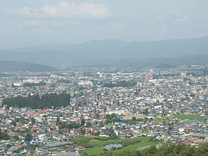
Geographische Lage in Japan 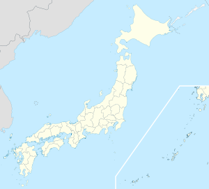

Region: Tōhoku Präfektur: Yamagata Koordinaten: 37° 55′ N, 140° 7′ O37.922222222222140.11666666667Koordinaten: 37° 55′ 20″ N, 140° 7′ 0″ O Basisdaten Fläche: 548,74 km² Einwohner: 89.009
(1. Oktober 2011)Bevölkerungsdichte: 162 Einwohner je km² Gemeindeschlüssel: 06202-2 Symbole Flagge/Wappen: 
Baum: Nördliche japanische Hemlocktanne Blume: Rhododendron Rathaus Adresse: Yonezawa City Hall
5-2-25, Kanaike
Yonezawa-shi
Yamagata 992-8501Webadresse: http://www.city.yonezawa.yamagata.jp Lage Yonezawas in der Präfektur Yamagata 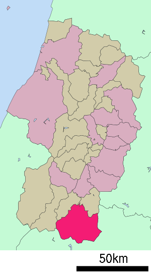
Yonezawa (jap. 米沢市, -shi) ist eine Stadt in der Präfektur Yamagata in Japan.
Die Stadt ist berühmt für ihr Rindfleisch Yonezawa-Gyū.
Inhaltsverzeichnis
Geographie
Yonezawa liegt südlich von Yamagata und nordwestlich von Fukushima.
Geschichte
Die Stadt Yonezawa wurde am 1. April 1889 gegründet.
Sehenswürdigkeiten
- Burg Yonezawa
- Yōzan-Shintō-Schrein
Verkehr
- Straßen:
- Nationalstraße 13
- Nationalstraße 121,287
- Zug:
Söhne und Töchter der Stadt
- Yukio Sakano (* 1976), japanischer Skispringer
- Date Masamune (1567-1636), Daimyo
Städtepartnerschaft
 Moses Lake, USA
Angrenzende Städte und Gemeinden
- Präfektur Yamagata
- Iide
- Takahata
- Kawanishi
- Präfektur Fukushima
- Fukushima
- Kitakata
- Inawashiro
- Kitashiobara
Weblinks
 Commons: Yonezawa – Sammlung von Bildern, Videos und Audiodateien
 Gemeinden und Landkreise in der Präfektur Yamagata
Kreisfreie Städte (shi): Higashine | Kaminoyama | Murayama | Nagai | Nan’yō | Obanazawa | Sagae | Sakata | Shinjō | Tendō | Tsuruoka | Yamagata (Verwaltungssitz) | Yonezawa
Akumi-gun: Yuza | Higashimurayama-gun: Nakayama | Yamanobe | Higashiokitama-gun: Kawanishi | Takahata | Higashitagawa-gun: Shōnai | Mikawa | Kitamurayama-gun: Ōishida | Mogami-gun: Funagata | Kaneyama | Mamurogawa | Mogami | Okura | Sakegawa | Tozawa | Nishimurayama-gun: Asahi | Kahoku | Nishikawa | Ōe | Nishiokitama-gun: Iide | Oguni | Shirataka
Wikimedia Foundation.
Schlagen Sie auch in anderen Wörterbüchern nach:
Yonezawa — Yonezawa, Hauptstadt der japan. Provinz Uzen, im mittlern Nippon, nördlich vom Iwanashirosee, in Reis und Tabak liefernder Ebene, mit altem Schloß und vielen Wohnungen der Samurai und (1906) 33,063 Einwohnern … Meyers Großes Konversations-Lexikon
Yonezawa — 37°55′N 140°7′E / 37.917, 140.117 Yonezawa shi … Wikipédia en Français
Yonezawa — Original name in latin Yonezawa Name in other language Jonezava, Yonezawa, mi ze shi, Йонезава State code JP Continent/City Asia/Tokyo longitude 37.91667 latitude 140.11667 altitude 243 Population 94486 Date 2012 01 19 … Cities with a population over 1000 database
Yonezawa — ▪ Japan city, southern Yamagata ken (prefecture), north central Honshu, Japan. From the Muromachi period (1338–1573) to the Meiji Restoration (1868) it was a castle town of the Uesugi (Uesugi Family) daimyo family. The ruling family… … Universalium
Yonezawa Domain — (米沢藩, Yonezawa han ) was a feudal domain ( han ) of Tokugawa Japan, controlled by daimyō of the Uesugi clan. Covering the Okitama district of Dewa province, in what is today southeastern Yamagata Prefecture, the territory was ruled from Yonezawa… … Wikipedia
Yonezawa Toys — (known also as Yone or simply Y) was one of Japan s largest and most prodigious post war toy manufacturers and an early participant in the growing radio control market. The company was founded in the 1950s in Tokyo and focused on the production… … Wikipedia
Yonezawa PR21 — (also known as Party Room 21 ) created Famicom and Super Famicom games during the 1980s and the 1990s. Their golden years consisted of games released between the year 1989 and 1994. Their most notable titles during their years of production were… … Wikipedia
Yonezawa, Yamagata — Infobox City Japan Name= Yonezawa JapaneseName= 米沢市 Map Region= Tōhoku Prefecture= Yamagata District= Area km2= 548.74 PopDate= January 2008 Population= 91,704 Density km2= 167 Coords= LatitudeDegrees= 37 LatitudeMinutes= 55 LatitudeSeconds=… … Wikipedia
Yonezawa (Yamagata) — 米沢市 Yonezawa … Wikipedia Español
Yonezawa Station — Infobox Station name= nihongo|Yonezawa Station|米沢駅|Yonezawa eki type= image size= image caption= address= coordinates=coord|37.9096|140.128|format=dms|display=title,inline|type:railwaystation region:JP line= other= structure= platform= depth=… … Wikipedia
Yonezawa


18+
© Academic, 2000-2024
- Kontaktieren Sie uns: Unterstützung, Werbung
Wörterbücher Export, schritte mit PHP, Joomla, Drupal, WordPress, MODx.