- Yam Island
-
Yam Island
(Iama)Landsat-Bild von Yam Island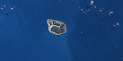
Gewässer Pazifischer Ozean Geographische Lage 9° 54′ 3″ S, 142° 46′ 27″ O-9.9008333333333142.77416666667160Koordinaten: 9° 54′ 3″ S, 142° 46′ 27″ O Länge 2,3 km Breite 1,2 km Fläche 1,73 km² Höchste Erhebung 160 m Einwohner 311 (2006)
180 Einw./km²Lage der Torres-Strait-Inseln: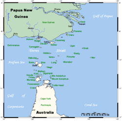
Yam Island etwa in der Bildmitte, links.Yam Island, auch Iama genannt, ist eine Insel im Zentrum des Archipels der Torres-Strait-Inseln. Von der Südküste Papua-Neuguineas ist sie 65 Kilometer, von der Nordküste Australiens 95 Kilometer entfernt.
Verwaltungstechnisch gehört sie zu den Central Islands, einer Inselregion im Verwaltungsbezirk Torres Shire des australischen Bundesstaats Queensland.
Die 173 Hektar große, hügelige Insel ist von einem Saumriff umgeben. In der Inselmitte wurde eine 800 Meter lange Start- und Landebahn für Kleinflugzeuge angelegt. Die einzige Ansiedlung liegt an der Westküste; nach dem Zensus von 2006 leben 311 Menschen auf Yam Island. 2001 waren es noch 338.
Siehe auch
Weblinks
Inselregionen, Hauptinseln und Inselgruppen im Archipel der Torres-Strait-Inselnzu Papua-Neuguinea gehörige Torres-Strait-Inseln: Bristow Island | Daru Island | Parama Island • Kawai-Inseln | Talbot-Inseln
Top Western: Boigu | Dauan | Deliverance | Saibai | Turnagain • Talbot-Inseln
Western: Badu | Mabuiag | Moa | Portlock | Tobin • Bellevue-Inseln | Duncan-Inseln | Farewell-Inseln | Kulbi-Inseln
Central: Aureed | Bourke | Coconut | Sassie | Sue | Yam | Yorke • Bourke-Inseln | The Three Sisters | Yorke-Inseln
Eastern: Bramble | Darnley | Murray | Stephens • Murray-Inseln
Inner: Albany | Booby | Crab | Entrance | Friday | Goods | Hammond | Horn | Packe | Port Lihou | Prince-of-Wales | Thursday | Wednesday • Manar-Inseln | Red-Wallis-Inseln | Thursday-Inseln | Tuesday-Inseln
Wikimedia Foundation.
Schlagen Sie auch in anderen Wörterbüchern nach:
Yam Island (Queensland) — Yam Island (Iama Island) is an island in the Bourke Isles, 100km North East of Thursday Island Queensland, Australia in the Tancred Passage Torres Strait.This island is one of the Torres Strait Islands. Its indigenous language is Kulkalgau Ya, a… … Wikipedia
Yam Island Airport — airport codes|XMY|YYMI is an airport in Yam Island, Queensland, Australia.Airlines and destinations*Aero Tropics Air Services (Bamaga, Coconut Island, Horn Island, Warraber Island, Yorke Island) *Regional Pacific Airlines (Coconut… … Wikipedia
Yam Islands — The Yam Islands, Yamsky Islands or Yamskiye Islands (Ямские острова; Yamskiye Ostrova), is a small island group located close to the coast in the northern Sea of Okhotsk. It lies about 250 Km east of Magadan, only 10 Km from the shores of the… … Wikipedia
Yam (vegetable) — Yam is the common name for some species in the genus Dioscorea (family Dioscoreaceae).These are perennial herbaceous vines cultivated for the consumption of their starchy tubers in Africa, Asia, Latin America and Oceania. There are hundreds of… … Wikipedia
Yam O — Sunny Bay redirects here. For the MTR station, see Sunny Bay (MTR) Yam O (zh t|t=陰澳) is a bay located on the northeast shore of Lantau Island, in the New Territories of Hong Kong. It is part of the Tsuen Wan Rural West constituency of the Tsuen… … Wikipedia
Albany Island (Queensland) — w1 Albany Island Lage der Torres Strait Inseln Gewässer Pazifischer Ozean Inselgruppe … Deutsch Wikipedia
Boigu Island — Lage der Torres Strait Inseln: Boigu oben, Mitte. Gewässer Pazifischer Ozean Ins … Deutsch Wikipedia
Mer Island — w1 Murray Island (Mer) Lage der Torres Strait Inseln: Murray (Mer) Bildmitte, rechts. Gewässer Pazifischer Ozean … Deutsch Wikipedia
Mulgrave Island — w1 Badu Island Lage der Torres Strait Inseln: Badu Island in der Bildmitte, links. Gewässer Pazifischer Ozean … Deutsch Wikipedia
Stephen Island — w1 Stephen Island (Ugar) Lage der Torres Strait Inseln: Stephen Island (Ugar) Bildmitte, oben. Gewässer Pazifisc … Deutsch Wikipedia
Yam Island


18+
© Academic, 2000-2024
- Kontaktieren Sie uns: Unterstützung, Werbung
Wörterbücher Export, schritte mit PHP, Joomla, Drupal, WordPress, MODx.