- Wyong Shire
-
Shire of Wyong 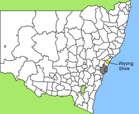
Lage des Wyong Shire in New South WalesGliederung Staat:  Australien
Bundesstaat:  New South Wales
Verwaltungssitz: Wyong Daten und Zahlen Fläche: 745 km² Einwohner: 139.801 (2006) [1] Bevölkerungsdichte: 188 Einwohner je km² Wards: 2 -33.266666666667151.35Koordinaten: 33° 16′ S, 151° 21′ OWyong Shire ist ein lokales Verwaltungsgebiet (LGA) im australischen Bundesstaat New South Wales. Das Gebiet ist 745 km² groß und hat etwa 140.000 Einwohner.
Wyong liegt an der Pazifikküste in der Region um die Metropole Sydney etwa 90 km nördlich des Stadtzentrums. Das Gebiet umfasst 96 Ortsteile und Ortschaften, darunter Bateau Bay, Berkeley Vale, Brush Creek, Budgewoi, Chittaway Point, Dooralong, Durren Durren, The Entrance, Gorokan, Ourimbah, Palm Grove, Palmdale, Tuggerah, Warnervale, Wyong, Yarramalong sowie Teile von Kulnura, Lisarow, Somersby und Wyee. Der Sitz des Shire Councils befindet sich in der Ortschaft Wyong in der Osthälfte der LGA am Tuggerah Lake, wo etwa 3.100 Einwohner leben.
Erste Siedlungen gab es in der Gegend von Wyong bereits Mitte des 19. Jahrhunderts, aber erst mit der Eisenbahnlinie von Newcastle nach Sydney wuchs die Besiedlung. Der Holztransport von nördlicheren Gebieten nach Sydney machte Wyong zu einem Handels- und Verwaltungszentrum der Region. Bald wurde die Stadt auch zu einem Wochenend- und Altersruhesitz der Bewohner der beiden Großstädte und seit der Anbindung an Sydney durch den Freeway 3 ist die Bevölkerungszahl geradezu explodiert. Heute leben über 140.000 Einwohner in Wyong und über 316.000 im gesamten Gebiet der Central Coast.
Verwaltung
Der Wyong Shire Council hat zehn Mitglieder, die von den Bewohnern der zwei Wards gewählt werden (je fünf aus Ward A und B). Diese beiden Bezirke sind unabhängig von den Ortschaften festgelegt. Aus dem Kreis der Councillor rekrutiert sich auch der Mayor (Bürgermeister) des Councils.
Weblinks
Einzelnachweise
- ↑ Australian Bureau of Statistics (25. Oktober 2007): Wyong (A) (Local Government Area) (Englisch). 2006 Census QuickStats. Abgerufen am 6. April 2010.
Kategorie:- Local Government Area in New South Wales

Wikimedia Foundation.