- Wyoming County (New York)
-
Verwaltung US-Bundesstaat: New York Verwaltungssitz: Warsaw Gründung: 19. Mai 1841 Gebildet aus: Genesee County Vorwahl: 001 585 Demographie Einwohner: 43.424 (2000) Bevölkerungsdichte: 28,3 Einwohner/km² Geographie Fläche gesamt: 1.545 km² Wasserfläche: 9 km² Karte 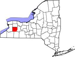
Website: www.wyomingco Wyoming County[1] ist ein County im Osten des US-Bundesstaates New York. Bei der Volkszählung im Jahr 2000 hatte das County 43.424 Einwohner und eine Bevölkerungsdichte von 28 Einwohner pro Quadratkilometer. Der Verwaltungssitz (County Seat) ist Warsaw.
Geografie
Das County hat eine Fläche von 1545 Quadratkilometern, wovon 9 Quadratkilometer Wasserfläche sind.
Städte und Ortschaften
- Arcade
- Attica
- Bennington
- Castile
- Covington
- Eagle
- Gainesville
- Genesee Falls
- Java
- Middlebury
- Orangeville
- Perry
- Pike
- Portageville
- Sheldon
- Silver Springs
- Warsaw
- Wethersfield
- Wyoming
Einzelnachweise
- ↑ GNIS-ID: 974158. Abgerufen am 22. Februar 2011 (englisch).
42.825-78.085Koordinaten: 42° 50′ N, 78° 5′ W
Liste der Countys in New York
Albany | Allegany | Bronx | Broome | Cattaraugus | Cayuga | Chautauqua | Chemung | Chenango | Clinton | Columbia | Cortland | Delaware | Dutchess | Erie | Essex | Franklin | Fulton | Genesee | Greene | Hamilton | Herkimer | Jefferson | Kings (Brooklyn) | Lewis | Livingston | Madison | Monroe | Montgomery | Nassau | New York (Manhattan) | Niagara | Oneida | Onondaga | Ontario | Orange | Orleans | Oswego | Otsego | Putnam | Queens | Rensselaer | Richmond (Staten Island) | Rockland | Saratoga | Schenectady | Schoharie | Schuyler | Seneca | St. Lawrence | Steuben | Suffolk | Sullivan | Tioga | Tompkins | Ulster | Warren | Washington | Wayne | Westchester | Wyoming | Yates
Wikimedia Foundation.
Schlagen Sie auch in anderen Wörterbüchern nach:
Wyoming County, New York — Infobox U.S. County county = Wyoming County state = New York map size = 250 founded = 1841 seat = Warsaw | area total sq mi =596 area water sq mi =4 area percentage = 0.59% census yr = 2000 pop = 43424 density km2 =28 web = www.wyomingco.net… … Wikipedia
National Register of Historic Places listings in Wyoming County, New York — Location of Wyoming County in New York … Wikipedia
List of county routes in Wyoming County, New York — The following is a list of county routes in Wyoming County, New York. Most of these routes serve as connections between major routes in the county. Wyoming County does not display County Route signs, however most county route numbers are listed… … Wikipedia
Silver Lake, Wyoming County, New York — Infobox Settlement name = Silver Lake, New York settlement type = Unincorporated community nickname = motto = imagesize = image caption = image pushpin pushpin label position = none pushpin map caption = Location of Silver Lake in New York… … Wikipedia
Cattaraugus County, New York — Coordinates: 42°14′N 78°41′W / 42.24°N 78.68°W / 42.24; 78.68 … Wikipedia
Genesee County, New York — Infobox U.S. County county = Genesee County state = New York map size = 250 founded = March 30 1802 seat = Batavia area total sq mi =495 area water sq mi =1 area percentage = 0.25% census yr = 2000 pop = 60370 density km2 =47 web = www.co.genesee … Wikipedia
Livingston County, New York — Infobox U.S. County county = Livingston County state = New York map size = 250 founded = 1821 seat = Geneseo | area total sq mi =640 area water sq mi =8 area percentage = 1.30% census yr = 2000 pop = 64328 density km2 =39 web =… … Wikipedia
Richmond County (New York) — Verwaltung US Bundesstaat: New York Verwaltungssitz: Adresse des Verwaltungssitzes: Gründung: 1683 … Deutsch Wikipedia
Allegany County, New York — Infobox U.S. County county = Allegany County state = New York map size = 250 founded = 1806 seat = Belmont | area total sq mi =1034 area water sq mi =4 area percentage = 0.41% census yr = 2000 pop = 49927 density km2 =19 web = www.alleganyco.com… … Wikipedia
Erie County, New York — Infobox U.S. County county = Erie County state = New York map size = 250 founded = 1821 seat = Buffalo | area total sq mi =1227 area land sq mi =1044 area water sq mi =183 area percentage = 14.89% census yr = 2000 pop = 950265 density km2 =351… … Wikipedia
Wyoming County (New York)

18+
© Academic, 2000-2024
- Kontaktieren Sie uns: Unterstützung, Werbung
Wörterbücher Export, schritte mit PHP, Joomla, Drupal, WordPress, MODx.