- Wild Rice River (North Dakota)
-
Wild Rice River 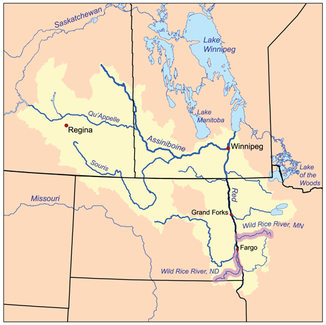
Das Einzugsgebiet des Red River of the North, beide Wild Rice River sind hervorgehoben
Daten Gewässerkennzahl US: 1035247 Lage North Dakota (USA) Flusssystem Nelson River Abfluss über Red River of the North → Winnipegsee → Nelson River → Hudson Bay Quelle in der Brampton Township, Sargent County
46° 0′ 56″ N, 97° 47′ 8″ W46.015555555556-97.785555555556391Quellhöhe 391 m Mündung Red River of the North bei Frontier, Cass County 46.756666666667-96.79267Koordinaten: 46° 45′ 24″ N, 96° 47′ 24″ W
46° 45′ 24″ N, 96° 47′ 24″ W46.756666666667-96.79267Mündungshöhe 267 m[1] Höhenunterschied 124 m Länge 390 km Einzugsgebiet 5.783 km² Abflussmenge MQ: 3 m³/s 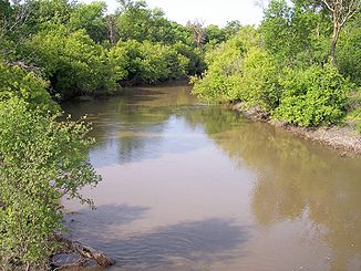
Der Wild Rice River bei Abercrombie, North Dakota (2007).
Der Wild Rice River ist ein etwa 390 Kilometer langer[2] gewundener nordwärts fließender linker Nebenfluss des Red River of the North im Südosten des US-Bundesstaates North Dakota.[3] Seine ZufIüsse entwässern auch einen kleinen Teil des Nordens von South Dakota. Über den Red River, den Winnipegsee und den Nelson River ist er Teil der Einzugsgebietes der Hudson Bay und entwässert ein Gebiet von 5783 km² in der Region des Red River Valleys.[4] Er ist einer von zwei Zuflüssen des Red River of the North mit diesem Namen; der andere ist der Wild Rice River in Minnesota. Trotz seiner Länge handelt es sich um einen relativ kleinen Fluss, dessen Schüttung im Jahresdurchschnitt nur etwa 3 m³/s beträgt.
Inhaltsverzeichnis
Lauf
Der Fluss entspringt als ein nichtstetiges Gewässer in der Brampton Township, etwa 10 km südlich von Cogswell im Südosten des Sargent County und fließt anfänglich extrem mäandrierend durch diesen und den Richland County, durch das Tewaukon-Reservat und an den Städten Cayuga, Mantador und Great Bend vorbei, wo er schließlich nach Norden schwenkt. Westlich von Wahpeton beginnt er einen parallelen Verlauf zum Red River, dem er bis zu seiner Mündung im Cass County, etwa fünf Kilometer südlich von Frontier in einem Abstand von fünf bis elf Kilometern in starken Windungen folgt.[5]
Abflussmenge
Der United States Geological Survey betreibt etwa fünf Kilometer nordwestlich von Abercrombie einen Pegel. Zwischen 1932 und 2005 betrug dort die langjährige Abflussmenge im Jahresdurchschnitt etwa 3 m³/s. Der höchste Wert wurde am 11. April 1969 mit 270 m³/s beobachtet.[1]
Einzelnachweise
- ↑ a b USGS - Geographic Names Information System - Wild Rice River (ND)
- ↑ National Assessment Database: Assessment Data for the State of North Dakota Year 2004. S. Western Wild Rice Watershed. United States Environmental Protection Agency. Abgerufen am 15. Juni 2007.. Summe der Flusssegmente, mit dem Oberlauf des Wild Rice Creeks auf etwa zehn Meilen anhand der Angaben im DeLorme und den Koordinaten im GNIS geschätzt und auf 390 Kilometer gerundet.
- ↑ Wild Rice River (North Dakota) im Geographic Names Information System des United States Geological Survey
- ↑ Red River of the North, Reconnaissance Report: Wild Rice River. Defense Technical Information Center, United States Department of Defense (December 1980). Abgerufen am 15. Juni 2007.
- ↑ North Dakota Atlas & Gazetteer, S. 52-53, 63-64, Yarmouth, Me.: DeLorme 1999, ISBN 0-89933-343-5
Siehe auch
Kategorien:- Flusssystem Red River of the North
- Fluss in Nordamerika
- Fluss in North Dakota


Wikimedia Foundation.