- Wheatfield (New York)
-
Wheatfield 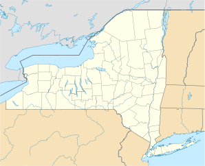

Wheatfield Lage in New YorkBasisdaten Gründung: 1836 Staat: Vereinigte Staaten Bundesstaat: New York County: Koordinaten: 43° 6′ N, 78° 54′ W43.092222222222-78.895176Koordinaten: 43° 6′ N, 78° 54′ W Zeitzone: Eastern Standard Time (UTC−5) Einwohner: 15.768 (Stand: 2005) Bevölkerungsdichte: 218,1 Einwohner je km² Fläche: 74,1 km² (ca. 29 mi²)
davon 72,3 km² (ca. 28 mi²) LandHöhe: 176 m Postleitzahlen: 14120, 14304, 14132 Vorwahl: +1 716 FIPS: 36-81380 GNIS-ID: 0979632 Webpräsenz: www.wheatfield.ny.us Wheatfield (deutsch Weizenfeld) ist eine Stadt im südwestlichen Teil von Niagara County, New York, Vereinigte Staaten von Amerika. Bei der Volkszählung von 2005 wurden 15.768 Einwohner gezählt. Der Name stammt aus der landwirtschaftlichen Nutzung der Umgebung der Stadt, dem Weizenanbau.
Wirtschaft
Während des Zweiten Weltkriegs entwickelte sich die Stadt zu einem Industriestandort. Der größte Betrieb war die Bell Aircraft Corporation, die zunächst das Kampfflugzeug P-39 Airacobra und später andere Produkte für die Luft- und Raumfahrtindustrie fertigte.
Kategorie:- Ort in New York

Wikimedia Foundation.