- West Quoddy Head
-
 West Quoddy Head Lighthouse
Das West Quoddy Head ist der östlichste Punkt auf dem Festland des Bundesstaates Maine und somit der Vereinigten Staaten von Amerika. Es bildet den westlichen Eingang zur Cobscook Bay und zum St. Croix River und ist durch den Quoddy Head State Park unter Naturschutz gestellt. Die Koordinaten des Leuchtturms werden mit 44°38'54"N und 66°57'02"W angegeben.
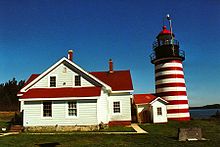
1808 wurde ein Leuchtturm aus Bruchmauerwerk hergestellt. Wie alle vor 1850 errichteten Leuchttürme in Maine – mit Ausnahme des Portland Head Light – wies er eine Höhe von 49 Feet (ca. 14 m) auf. Ein Ersatz dieses Leuchtturms erfolgte 1853, der wegen minderwertigen Mörtels 1858 abgerissen wurde. Daraufhin wurde die heute noch existierende, von Ziegelmauerwerk umhüllte gusseiserne Struktur errichtet. Das Gebäude ist 49 ft (ca. 15 m) hoch, der Durchmesser beträgt an der Basis 16 ft (ca. 4,9 m) und verjüngt sich auf 14 ft. (ca. 4,3 m). Das rot-weiß gestreifte Gebäude besitzt heute 15 horizontale Streifen (8 × rot, 7 × weiß), historische Aufnahmen zeigen 16 Streifen (8 × rot, 8 × weiß) oder 13 Streifen (7 × rot, 6 × weiß). Seit 1988 ist der Leuchtturm automatisiert, ein computergesteuerter Mechanismus betreibt das weiße Blinklicht, welches eine Höhe von 83 Fuß (ca. 25 m) über dem Meeresspiegel erreicht. Die Sichtweite des ganztägig blinkenden Lichts beträgt 15 bis 18 Seemeilen (24 bis 29 Kilometer). Durch die U.S. Coast Guard wurde 2003 der Anstrich erneuert, im Folgejahr wurden die Spiegel der Laterne generalüberholt. Das 1857 errichtete Wohnhaus des Leuchtturmwärters enthält heute ein von der West Quoddy Head Light Keepers Association unterhaltenes Museum, welches vom Memorial Day bis Mitte Oktober geöffnet ist.
Den besten Blick auf den Leuchtturm hat man vom Ende der Quoddy Head Road, die vom Zentrum von Lubec zum Parkplatz nahe der Küste im State Park führt.
Weblinks
 Commons: West Quoddy Head Light – Sammlung von Bildern, Videos und Audiodateien44.815-66.950556Koordinaten: 44° 48′ 54″ N, 66° 57′ 2″ WKategorien:
- Geographie (Maine)
- Leuchtturm in den Vereinigten Staaten
- Maritimes Museum
- Washington County (Maine)

Wikimedia Foundation.