- West Devon
-
Borough of West Devon 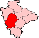
Lage in DevonStatus Borough Region South West England Verw.grafschaft Devon Verwaltungssitz Tavistock Fläche 1161,08 km² (17.) Einwohner 52.100 (338.) ONS-Code 18UH Website www.teignbridge.gov.uk West Devon ist ein Verwaltungsbezirk mit dem Status eines Borough in der Grafschaft Devon in England. Verwaltungssitz ist die Stadt Tavistock; weitere bedeutende Orte sind Chagford, Okehampton und Princetown.
Der Bezirk wurde am 1. April 1974 gebildet und entstand aus der Fusion des Municipal Borough Okehampton sowie der Rural Districts Okehampton und Tavistock.
Städtepartnerschaften
- Wesseling, Nordrhein-Westfalen (seit 1983)
 Districts der Verwaltungsgrafschaft Devon
East Devon | Exeter | Mid Devon | North Devon | South Hams | Teignbridge | Torridge | West Devon
Wikimedia Foundation.
Schlagen Sie auch in anderen Wörterbüchern nach:
West Devon — es un districto del gobierno local y la ciudad en Devon, Inglaterra. Ciudades en el distrito incluyen Chagford, Okehampton, Princetown, y Tavistock, en el que se basa el consejo. El distrito se formó el 1 de abril de 1974, bajo la Ley de Gobierno … Wikipedia Español
West Devon — is a local government district and borough in Devon, England. Towns in the district include Chagford, Okehampton, Princetown and Tavistock where the council is based.The district was formed on April 1, 1974, under the Local Government Act 1972,… … Wikipedia
West Devon — ▪ district, England, United Kingdom borough (district), administrative and historic county of Devon, southwestern England. The borough lies directly north of the city of Plymouth. West Devon encompasses most of Dartmoor in the county s… … Universalium
West Devon — 50°38′N 4°06′W / 50.633, 4.1 … Wikipédia en Français
West Devon (UK Parliament constituency) — West Devon Former County constituency for the House of Commons February 1974 (February 1974)–1983 (1983) … Wikipedia
West Devon local elections — West Devon Council is elected every four years.Political controlIndependent 1973 1987No overall control 1987 1991Independent 1991 1995Liberal Democrat 1995 1999No overall control 1999 presentCouncil electionsWest Devon Council election, 1999West… … Wikipedia
West Devon Way — The West Devon Way is a waymarked long distance footpath in South West England in the United Kingdom. Length of the Route The West Devon Way runs for 58km (36 mi). The Route The route runs from the western fringes of Dartmoor National Park… … Wikipedia
District de West Devon — West Devon West Devon Statut District non métropolitain Géographie Pays … Wikipédia en Français
Torridge and West Devon (UK Parliament constituency) — Coordinates: 50°42′54″N 4°15′47″W / 50.715°N 4.263°W / 50.715; 4.263 … Wikipedia
South West Devon (UK Parliament constituency) — Coordinates: 50°23′42″N 3°59′31″W / 50.395°N 3.992°W / 50.395; 3.992 … Wikipedia
West Devon

18+
© Academic, 2000-2024
- Kontaktieren Sie uns: Unterstützung, Werbung
Wörterbücher Export, schritte mit PHP, Joomla, Drupal, WordPress, MODx.