Wentworth Shire

Wentworth Shire
Shire of Wentworth
Australia-Map-NSW-LGA-Wentworth.png
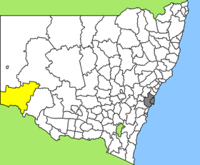
Lage des Wentworth Shire in New South Wales
Gliederung
Staat: Australien Australien
Bundesstaat: Flag of New South Wales.svg New South Wales
Verwaltungssitz: Wentworth
Daten und Zahlen
Fläche: 26.269 km²
Einwohner: 6.779 (2006) [1]
Bevölkerungsdichte: 0,3 Einwohner je km²
-33.3142.6

Wentworth Shire ist ein lokales Verwaltungsgebiet (LGA) im australischen Bundesstaat New South Wales. Das Gebiet ist 26.269 km² groß und hat etwa 6.800 Einwohner.

Wentworth liegt in der Südwestecke des Staates am Murray River, der Grenze zu Victoria, und ist etwa 1.000 km von der Metropole Sydney und 390 km von Adelaide entfernt. Das Gebiet umfasst 50 Ortsteile und Ortschaften, darunter Anabranch, Arumpo, Cal Lal, Curlwaa, Dareton, Gol, Gol, Monak, Mourquong, Palinyewah, Pan Ban, Pomona, Pooncarie, Rufus River und Wentworth. Der Sitz des Shire Councils befindet sich in der Ortschaft Wentworth in der Osthälfte der LGA, wo etwa 1.300 Einwohner leben.

Verwaltung

Der Wentworth Shire Council hat neun Mitglieder, die von den Bewohnern der LGA gewählt werden. Wellington ist nicht in Bezirke untergliedert. Aus dem Kreis der Councillor rekrutiert sich auch der Mayor (Bürgermeister) des Councils.

Weblinks

Einzelnachweise

  1. Australian Bureau of Statistics (25. Oktober 2007): Wentworth (A) (Local Government Area) (Englisch). 2006 Census QuickStats. Abgerufen am 6. April 2010.

Wikimedia Foundation.

Игры ⚽ Нужна курсовая?

Schlagen Sie auch in anderen Wörterbüchern nach:

  • Wentworth Shire Council — Infobox Australian Place | type = lga name = Wentworth Shire state = nsw caption = pop = 7,236 density = 0.28 area = 26269 est = seat = Wentworth (26 28 Adelaide Street) mayor = Margaret Thomson region = Far West url =… …   Wikipedia

  • Wentworth County — For the former county in Canada, see Wentworth County, Ontario. Map of all coordinates from Google Map of all coordinates from Bing Export all coordinates as KML …   Wikipedia

  • Wentworth, New South Wales — Infobox Australian Place | type = town name = Wentworth state = nsw caption = Darling Street, Wentworth lga = Wentworth Shire postcode = 2648 est = pop = 1303 (2006)Census 2006 AUS | id = UCL182600 | name = Wentworth (Urban Centre/Locality) |… …   Wikipedia

  • Wentworth (Australie) — Pour les articles homonymes, voir Wentworth. 34° 06′ 19″ S 141° 54′ 58″ E / …   Wikipédia en Français

  • Shire of Mildura — Infobox Australian Place | type = lga name = Shire of Mildura state = vic region = area = 10145 est = 1890 seat = Irymple pop = 21230 (1992) [cite book|title=Victorian Year Book|author=Australian Bureau of Statistics, Victoria… …   Wikipedia

  • Wentworth — I. /ˈwɛntwɜθ/ (say wentwerth) noun 1. D Arcy, 1762?–1827, Australian pioneer surgeon and magistrate, born in Ireland. 2. William Charles, 1790–1872, son of D Arcy Wentworth, Australian explorer and politician; active in gaining self government… …  

  • Wakool Shire — Shire of Wakool New South Wales Location in New South Wales Population: 4,427(2009) …   Wikipedia

  • Balranald Shire Council — Infobox Australian Place | type = lga name = Balranald Shire state = nsw caption = location in NSW pop = 2,755 density = 0.13 area = 21699 est = seat = Balranald (70 Market Street) mayor = Alan Purtill region = Murray url =… …   Wikipedia

  • Muswellbrook Shire — New South Wales Location in New South Wales Population …   Wikipedia

  • Conargo Shire — New South Wales Location in New South Wales Population: 1,700(2009) …   Wikipedia

Share the article and excerpts

Direct link
Do a right-click on the link above
and select “Copy Link”