- Welwyn Hatfield
-
Borough of Welwyn Hatfield 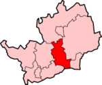
Lage in HertfordshireStatus Borough Region East of England Verw.grafschaft Hertfordshire Verwaltungssitz Welwyn Garden City Fläche 129,55 km² (223.) Einwohner 106.700 (210.) ONS-Code 26UL Website www.welhat.gov.uk Welwyn Hatfield ist ein Verwaltungsbezirk mit dem Status eines Borough in der Grafschaft Hertfordshire in England. Er grenzt im Süden an Greater London und besteht aus den Städten Welwyn Garden City und Hatfield.
Der Bezirk wurde am 1. April 1974 gebildet und entstand aus der Fusion des Urban District Welwyn Garden City sowie der Rural Districts Welwyn und Hatfield. Der Bezirk hatte zunächst den Status eines District und stellte den Antrag, zu einem Borough erhoben zu werden. Der Privy Council gab am 15. November 2005 dazu seine Einwilligung, der Wechsel erfolgte am 22. Mai 2006.
Broxbourne | Dacorum | East Hertfordshire | Hertsmere | North Hertfordshire | St Albans | Stevenage | Three Rivers | Watford | Welwyn Hatfield
Wikimedia Foundation.
Schlagen Sie auch in anderen Wörterbüchern nach:
Welwyn Hatfield — For the constituency, see Welwyn Hatfield (UK Parliament constituency) Borough of Welwyn Hatfield Non metropolitan district, Borough … Wikipedia
Welwyn Hatfield — ▪ district, England, United Kingdom district, administrative and historic county of Hertfordshire, southeastern England, directly north of the metropolitan county of Greater London. Welwyn Hatfield district is an area of rolling, open… … Universalium
Welwyn Hatfield Borough Council — is the local authority for the Welwyn Hatfield non metropolitan district of England, the United Kingdom. Welwyn Hatfield is located in the centre of Hertfordshire, in the East of England region. The Council itself is based in Welwyn Garden City,… … Wikipedia
Welwyn Hatfield Times — is a local paper that was established in 1928 covering the area of Welwyn Hatfield district borough, along with Potters Bar in the Potters Bar edition of the paper.The Welwyn and Hatfield Times has always been at the heart of the community and… … Wikipedia
Welwyn Hatfield local elections — One third of Welwyn Hatfield Council is elected each year, followed by one year without election. Due to boundary changes, the whole council was subject to election in 2008.Political controlLabour 1973 1976Conservative 1976 1979Labour 1979… … Wikipedia
Welwyn Hatfield (UK Parliament constituency) — UK constituency infobox Name = Welwyn Hatfield Map1 = WelwynHatfield Map2 = Hertfordshire Type = County Year = 1974 Entity = Hertfordshire County = Hertfordshire EP = East of England MP = Grant Shapps Party = ConservativeWelwyn Hatfield is a… … Wikipedia
Welwyn Village — DEC … Deutsch Wikipedia
Hatfield (Hertfordshire) — Hatfield Ciudad del Reino Unido … Wikipedia Español
Hatfield, Hertfordshire — infobox UK place country = England latitude= 51.7627 longitude= 0.2284 official name= Hatfield population= 27,883 [United Kingdom Census 2001 [http://www.hertsdirect.org/infobase/docs/pdfstore/tabKS01sett.pdf] ] shire district= Welwyn Hatfield… … Wikipedia
Welwyn Garden City — distinguish|Welwyninfobox UK place country = England latitude= 51.8062 longitude= 0.1932 official name= Welwyn Garden City population= 43,252 [ [http://www.hertsdirect.org/infobase/docs/pdfstore/tabKS01sett.pdf Office for National Statistics,… … Wikipedia
Welwyn Hatfield

18+
© Academic, 2000-2024
- Kontaktieren Sie uns: Unterstützung, Werbung
Wörterbücher Export, schritte mit PHP, Joomla, Drupal, WordPress, MODx.