Weddin Shire

Weddin Shire
Shire of Weddin
Australia-Map-NSW-LGA-Warrumbungle.png
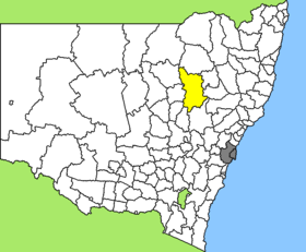
Lage des Weddin Shire in New South Wales
Gliederung
Staat: Australien Australien
Bundesstaat: Flag of New South Wales.svg New South Wales
Verwaltungssitz: Grenfell
Daten und Zahlen
Fläche: 3.410 km²
Einwohner: 3.641 (2006) [1]
Bevölkerungsdichte: 1,1 Einwohner je km²
Wards: 5
-33.883333333333148.08333333333

Weddin Shire ist ein lokales Verwaltungsgebiet (LGA) im australischen Bundesstaat New South Wales. Das Gebiet ist 3.410 km² groß und hat etwa 3.600 Einwohner.

Weddin liegt in der Region Central West des Staates etwa 360 km westlich der Metropole Sydney und 210 km nordwestlich der australischen Hauptstadt Canberra. Das Gebiet umfasst 27 Ortsteile und Ortschaften: Arramagong, Arramagong West, Berendebba, Bimbi, Gogalong, Brundah, Bungalong, Caragabal, Eualdrie, Eurabba, Glenelg, Grenfell, Iandra, Mogongong, Ooma, Piney Range, Pullabooka, Quandong, Warraderry, Weddin, Wirega und Teile von Bribbaree, Bumbaldry, Greenethorpe, Marsden, Quandialla und Wirrinya. Der Sitz des Shire Councils befindet sich in der Ortschaft Grenfell in der Osthälfte der LGA, wo etwa 2.000 Einwohner leben.

Verwaltung

Der Weddin Shire Council hat zehn Mitglieder, die von den Bewohnern der fünf Wards gewählt werden (je zwei aus den Wards A bis E). Diese fünf Bezirke sind unabhängig von den Ortschaften festgelegt. Aus dem Kreis der Councillor rekrutiert sich auch der Mayor (Bürgermeister) des Councils.

Weblinks

Einzelnachweise

  1. Australian Bureau of Statistics (25. Oktober 2007): Weddin (A) (Local Government Area) (Englisch). 2006 Census QuickStats. Abgerufen am 6. April 2010.

Wikimedia Foundation.

Игры ⚽ Нужно сделать НИР?

Schlagen Sie auch in anderen Wörterbüchern nach:

  • Weddin Shire Council — Infobox Australian Place | type = lga name = Weddin Shire state = nsw caption = Location in New South Wales pop = 3,653Census 2001 AUS|id=LGA18100|name=Weddin (A) (Local Government Area)|accessdate=2007 06 30|quick=on] area = 3410 est = seat =… …   Wikipedia

  • Cowra Shire — New South Wales Location in NSW Population: 12,945(2009) …   Wikipedia

  • Cowra Shire Council — Infobox Australian Place | type = lga name = Cowra Shire state = nsw caption = Location in NSW pop = 13,260Census 2001 AUS|id=LGA12350|name=Cowra (A) (Local Government Area)|accessdate=2007 06 30|quick=on] area = 2810 est = seat = Cowra (116… …   Wikipedia

  • Wakool Shire — Shire of Wakool New South Wales Location in New South Wales Population: 4,427(2009) …   Wikipedia

  • Young Shire Council — Infobox Australian Place | type = lga name = Young Shire caption = Location in New South Wales state=New South Wales region=South West Slopes area=2694 seat=Young (Boorowa St)cite web title=Young Shire Council publisher = Department of Local… …   Wikipedia

  • Muswellbrook Shire — New South Wales Location in New South Wales Population …   Wikipedia

  • Conargo Shire — New South Wales Location in New South Wales Population: 1,700(2009) …   Wikipedia

  • Murray Shire — This article is about the Murray Shire in New South Wales. For the Western Australia shire, see Shire of Murray. Murray Shire New South Wales …   Wikipedia

  • Narrandera Shire — New South Wales Location in New South Wales Population: 6 …   Wikipedia

  • Cobar Shire — New South Wales Location in New South Wales Population: 5 …   Wikipedia

Share the article and excerpts

Direct link
Do a right-click on the link above
and select “Copy Link”