- Visokoi Island
-
Visokoi Island NASA-Bild von Visokoi Island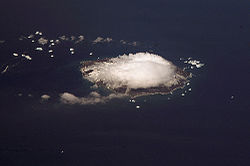
Gewässer Atlantischer Ozean Inselgruppe Südliche Sandwichinseln Geographische Lage 56° 42′ 40″ S, 27° 8′ 50″ W-56.711111111111-27.1472222222221005Koordinaten: 56° 42′ 40″ S, 27° 8′ 50″ W 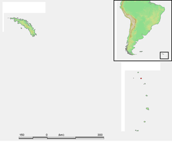
Länge 8 km Breite 6 km Fläche 34,5 km² Höchste Erhebung Mount Hodson
1.005 mEinwohner (unbewohnt) Visokoi Island ist eine unbewohnte Vulkaninsel des im südlichen Atlantischen Ozean gelegenen britischen Überseegebietes von Südgeorgien und den Südlichen Sandwichinseln.
Die Insel liegt rund 370 km südöstlich der Hauptinsel Südgeorgien und etwa 300 km nordöstlich der Antarktis, in der Inselgruppe der Südlichen Sandwichinseln, und bildet zusammen mit Zavodovski Island und Leskov Island die kleine Gruppe der Traversayinseln, deren südlichste Visokoi ist.
Die 8 × 6 km große Insel mit einer Landfläche von etwa 34,5 km² Fläche besteht im Grunde nur aus einem 1005 Meter hohen Stratovulkan, dem Mount Hodson, welcher 1830 und 1930 letzte Aktivitäten zeigte.
Entdeckt und benannt wurde Visokoi Island 1819 durch den deutschbaltischen Antarktisseefahrer Fabian Gottlieb von Bellingshausen. Dieser benannte die Insel nach einem russischen Begriff für Höhe, wegen der beeindruckten Erhebung des Vulkanbergs. Der Name des Vulkans geht auf Sir Arnold Weinholt Hodson, einem Gouverneur der Falklandinseln, zurück.
Weblinks
- Visokoi Island im Global Volcanism Program der Smithsonian Institution (englisch)
- Kurzbeschreibung mit Bild des Vulkans und Karte (englisch)

Südgeorgien: Annenkov | Bird | Clerke Rocks | Cooper | Grass | Kupriyanov | Pickersgill | Shag Rocks | Südgeorgien | Willis | Welcome
Südliche Sandwichinseln: Bellingshausen | Bristol | Candlemas | Cook | Leskov | Montagu | Morrell (Thule) | Saunders | Vindication | Visokoi | Zavodovski
Wikimedia Foundation.
Schlagen Sie auch in anderen Wörterbüchern nach:
Visokoi Island — is an uninhabited island in the Traversay Islands group of the South Sandwich Islands. It was discovered in 1819 by a Russian expedition under Fabian Gottlieb von Bellingshausen, who named the island Visokoi ( high ) because of its conspicuous… … Wikipedia
Bristol Island (Südsandwichinseln) — Vorlage:Infobox Insel/Wartung/Bild fehlt Bristol Island Gewässer Atlantischer Ozean Inselgruppe Südliche Sandwichinseln Geographische Lage … Deutsch Wikipedia
Cooper Island (Südgeorgien) — w1 Cooper Island Karte von Südgeorgien, auf der im Südosten Cooper Island zu erkennen ist Gewässer At … Deutsch Wikipedia
Grass Island (Südgeorgien) — w1 Grass Island Stromness Bay: Grass Island in der Mitte. Gewässer Atlantischer Ozean Geog … Deutsch Wikipedia
Morrell Island — Südliche Sandwichinseln: Die Morrell Insel befindet sich im Bild ganz unten. Die Insel Morrell, auch als Thule Island bekannt, ist eine der drei Inseln im Südatlantik, gelegen im subantarktischen Archipel der Südlichen Sandwichinseln, die die… … Deutsch Wikipedia
Thule Island — Südliche Sandwichinseln: Die Morrell Insel befindet sich im Bild ganz unten. Die Insel Morrell, auch als Thule Island bekannt, ist eine der drei Inseln im Südatlantik, gelegen im subantarktischen Archipel der Südlichen Sandwichinseln, die die… … Deutsch Wikipedia
Leskov Island (Südsandwichinseln) — Leskov Island NASA Bild von Leskov Island Gewässer Atlantischer Ozean Inselgruppe … Deutsch Wikipedia
Leskov Island — is a small uninhabited island in the Traversay Islands group of the South Sandwich Islands. It is less than 1.5 km (1 mile) long, and lies 48 km (30 miles) west of Visokoi Island. It was discovered in 1819 by a Russian expedition under… … Wikipedia
Zavodovski Island — NASA Bild von Zavodovski Island Gewässer Atlantischer Ozean Inselgruppe … Deutsch Wikipedia
Montagu Island — … Wikipedia
Visokoi Island


18+
© Academic, 2000-2024
- Kontaktieren Sie uns: Unterstützung, Werbung
Wörterbücher Export, schritte mit PHP, Joomla, Drupal, WordPress, MODx.