Vanua Levu

Vanua Levu
Vanua Levu
Vanua Levu
Vanua Levu
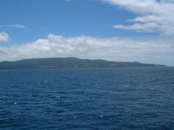
Gewässer Pazifischer Ozean
Inselgruppe Fidschi-Inseln
Geographische Lage 16° 33′ S, 179° 15′ O-16.55179.251032Koordinaten: 16° 33′ S, 179° 15′ O
Vanua Levu (Fidschi)
Vanua Levu
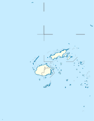
Länge 180 km
Breite 50 km
Fläche 5.587,1 km²
Höchste Erhebung Nasorolevu
1.032 m
Einwohner 130.000
23 Einw./km²
Hauptort Labasa

Vanua Levu [βaˈnua ˈleβu] (dt. „Großes Land“) ist mit 5587 km² Fläche[1] die zweitgrößte Insel im Südpazifik-Staat Fidschi.

Vanua Levu liegt etwa 70 km nördlich von Fidschis größter Insel Viti Levu und ähnelt in ihrer Form einem spitzen Dreieck. Auf der Insel leben etwa 130.000 Einwohner. Größte Siedlung ist die Stadt Labasa, höchster Berg der 1032 m hohe Nasorolevu.[2] Wichtigster Wirtschaftszweig Vanua Levus ist die Zucker-, aber auch die Kopraproduktion. Daneben spielt auch der Tourismus zunehmend eine Rolle.

Geschichte

Zu Beginn des 19. Jahrhunderts wurde einige Jahre lang Sandelholz aus den Wäldern der Insel geholt.

Einzelnachweise

  1. UNEP Islands Directory (englisch)
  2. Nasorolevu bei Peakbagger.com (englisch)

Wikimedia Foundation.

Игры ⚽ Нужна курсовая?

Schlagen Sie auch in anderen Wörterbüchern nach:

  • Vanua Levu — [vä no͞o′ä lev′o͞o] second largest of the Fiji Islands, northeast of Viti Levu: 2,145 sq mi (5,556 sq km) …   English World dictionary

  • Vanua Levu — (»das große Land«), zweitgrößte der Fidschiinseln (s. d., mit Textkärtchen), 185 km lang, bis 60 km breit und 6406 qkm groß mit 30,000 Einw., fast nur Eingeborne, In die Ostküste dringt die schutzlose Natevabai tief ein, die Savu Savubai an der… …   Meyers Großes Konversations-Lexikon

  • Vanua Levu — Vanua Levu, zweitgrößte der brit. Fidschiinseln, 6492 qkm, 30.000 E., gute Häfen im S. und W …   Kleines Konversations-Lexikon

  • Vanua Levu —   [v , vu], eine der Fidschiinseln (Fidschi).   …   Universal-Lexikon

  • Vanua Levu — Infobox Islands name = Vanua Levu image caption = Map of Vanua Levu image size = locator map custom = no native name = native name link = nickname = location = Pacific Ocean coordinates = coord|16|35|S|179|11|E|display=inline archipelago = Vanua… …   Wikipedia

  • Vanua Levu — Mapa de Fiyi. Vanua Levu es una isla volcánica, la de segundo mayor tamaño de Fiyi. Se sitúa en las coordenadas …   Wikipedia Español

  • Vanua Levu — /veuh nooh euh lev ooh/ an island in the S Pacific, one of the Fiji Islands. 94,000; 2137 sq. mi. (5535 sq. km). * * * Island (pop., including adjacent islands, 1996: 139,526), Fiji. Fiji s second largest island, it is 2,137 sq mi (5,535 sq km)… …   Universalium

  • Vanua Levu — 16°33′S 179°10′E / 16.55, 179.167 Vanua Levu est la seconde plus grande île de l archipel fidjien avec une superficie de 5587 km² …   Wikipédia en Français

  • Vanua Levu West (Indian Communal Constituency, Fiji) — Vanua Levu West Indian Communal is an electoral division of Fiji, one of 19 communal constituencies reserved for Indo Fijians. (Of the remaining 52 seats, 27 are reserved for other ethnic communities and 25, called Open Constituencies, are… …   Wikipedia

  • Vanua Levu Group — The Vanua Levu Group is an archipelago in northern Fiji. It takes its name from its predominant island, Vanua Levu. Among the other island in the group, the most important is Taveuni. Other islands in the group include Laucala, Matagi, Namena… …   Wikipedia

Share the article and excerpts

Direct link
Do a right-click on the link above
and select “Copy Link”