- Vanderburgh County
-
Verwaltung US-Bundesstaat: Indiana Verwaltungssitz: Evansville Adresse des
Verwaltungssitzes:County Courthouse
825 Sycamore Street
Evansville, IN 47708-1849Gründung: 7. Januar 1818 Gebildet aus: Gibson County
Posey County
Warrick CountyVorwahl: 001 812 Demographie Einwohner: 179.703 (2010) Bevölkerungsdichte: 295,6 Einwohner/km² Geographie Fläche gesamt: 611 km² Wasserfläche: 3 km² Karte 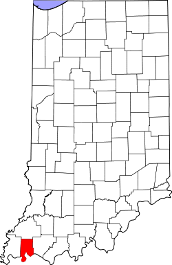
Website: www.vanderburghgov.org Das Vanderburgh County[2] ist ein County im US-amerikanischen Bundesstaat Indiana. Bei der Volkszählung im Jahr 2010 hatte das County 179.703 Einwohner und eine Bevölkerungsdichte von 295,6 Einwohnern pro Quadratkilometer. Der Verwaltungssitz (County Seat) ist Evansville.[3]
Inhaltsverzeichnis
Geografie
Das County liegt fast im äußersten Südwesten von Indiana am Ohio River, der die Grenze zu Kentucky bildet. Es hat eine Fläche von 611 Quadratkilometern, wovon 3 Quadratkilometer Wasserfläche sind. An das Vanderburgh County grenzen folgende Nachbarcountys:
Gibson County Posey County 
Warrick County Henderson County
(Kentucky)Geschichte
Das Vanderburgh County wurde am 7. Januar 1818 aus Teilen des Gibson County, Posey County und des Warrick County gebildet. Benannt wurde es nach William Henry Vanderburgh (1760-1812) , einem Offizier der Kontinentalarmee im Amerikanischen Unabhängigkeitskrieg und späteren Richter im Indiana - Territorium.
Demografische Daten
Historische Einwohnerzahlen Census Einwohner ± in % 1820 1798 — 1830 2611 50 % 1840 6250 100 % 1850 11.414 80 % 1860 20.552 80 % 1870 33.145 60 % 1880 42.193 30 % 1890 59.809 40 % 1900 71.769 20 % 1910 77.438 8 % 1920 92.293 20 % 1930 113.320 20 % 1940 130.783 20 % 1950 160.422 20 % 1960 165.794 3 % 1970 168.772 2 % 1980 167.515 -0,7 % 1990 165.058 -1 % 2000 171.922 4 % 2010 179.703 5 % Vor 1900[4] 1900–1990[5] 2000[6] 2010[7] Nach der Volkszählung im Jahr 2010 lebten im Vanderburgh County 179.703 Menschen in 72.843 Haushalten. Die Bevölkerungsdichte betrug 295,6 Einwohner pro Quadratkilometer.
Ethnisch betrachtet setzte sich die Bevölkerung zusammen aus 86,2 Prozent Weißen, 9,1 Prozent Afroamerikanern, 0,2 Prozent amerikanischen Ureinwohnern, 1,1 Prozent Asiaten sowie aus anderen ethnischen Gruppen; 2,3 Prozent stammten von zwei oder mehr Ethnien ab. Unabhängig von der ethnischen Zugehörigkeit waren 2,2 Prozent der Bevölkerung spanischer oder lateinamerikanischer Abstammung.
In den 72.843 Haushalten lebten statistisch je 2,31 Personen.
22,2 Prozent der Bevölkerung waren unter 18 Jahre alt, 63,4 Prozent waren zwischen 18 und 64 und 14,4 Prozent waren 65 Jahre oder älter. 51,8 Prozent der Bevölkerung war weiblich.
Das jährliche Durchschnittseinkommen eines Haushalts lag bei 42.404 USD. Das Pro - Kopf - Einkommen betrug 24.112 USD. 15,2 Prozent der Einwohner lebten unterhalb der Armutsgrenze.[8]
Städte und Gemeinden
- Darmstadt
Census-designated places (CDP)
- Highland
- Melody Hill
Einzelnachweise
- ↑ Auszug aus dem National Register of Historic Places. Abgerufen am 13. März 2011
- ↑ GNIS-ID: 450396. Abgerufen am 22. Februar 2011 (englisch).
- ↑ National Association of Counties Abgerufen am 20. November 2011
- ↑ U.S. Census Bureau - Census of Population and Housing Abgerufen am 15. März 2011
- ↑ Auszug aus Census.gov Abgerufen am 16. Februar 2011
- ↑ U.S. Census Buero - Volkszählungsdaten 2000 für das Vanderburgh County, IN Abgerufen am 20. November 2011
- ↑ United States Census 2010 Abgerufen am 20. November 2011
- ↑ U.S. Census Buero, State & County QuickFacts - Vanderburgh County Abgerufen am 20. November 2011
Weblinks
-
 Commons: Vanderburgh County, Indiana – Sammlung von Bildern, Videos und Audiodateien
 - Offizielle Webseite
- U.S. Census Buero, State & County QuickFacts - Vanderburgh County
- Yahoo Bildersuche - Vanderburgh County
- www.city-data.com - Vanderburgh County

Liste der Countys in Indiana
Adams | Allen | Bartholomew | Benton | Blackford | Boone | Brown | Carroll | Cass | Clark | Clay | Clinton | Crawford | Daviess | DeKalb | Dearborn | Decatur | Delaware | Dubois | Elkhart | Fayette | Floyd | Fountain | Franklin | Fulton | Gibson | Grant | Greene | Hamilton | Hancock | Harrison | Hendricks | Henry | Howard | Huntington | Jackson | Jasper | Jay | Jefferson | Jennings | Johnson | Knox | Kosciusko | LaGrange | Lake | LaPorte | Lawrence | Madison | Marion | Marshall | Martin | Miami | Monroe | Montgomery | Morgan | Newton | Noble | Ohio | Orange | Owen | Parke | Perry | Pike | Porter | Posey | Pulaski | Putnam | Randolph | Ripley | Rush | St. Joseph | Scott | Shelby | Spencer | Starke | Steuben | Sullivan | Switzerland | Tippecanoe | Tipton | Union | Vanderburgh | Vermillion | Vigo | Wabash | Warren | Warrick | Washington | Wayne | Wells | White | Whitley
Wikimedia Foundation.
Schlagen Sie auch in anderen Wörterbüchern nach:
Vanderburgh County — Admin ASC 2 Code Orig. name Vanderburgh County Country and Admin Code US.IN.163 US … World countries Adminstrative division ASC I-II
Vanderburgh County, Indiana — Infobox U.S. County county = Vanderburgh County state = Indiana map size = 175 founded = 1818 seat = Evansville | area total sq mi =236 area land sq mi =235 area water sq mi =1 area percentage = 0.49% census yr =2000 pop = 171922 density km2 =283 … Wikipedia
National Register of Historic Places listings in Vanderburgh County, Indiana — Location of Vanderburgh County in Indiana This is a list of the National Register of Historic Places listings in Vanderburgh County, Indiana. This is intended to be a complete list of the properties and districts on the National Register of… … Wikipedia
Old Vanderburgh County Courthouse — U.S. National Register of Historic Places … Wikipedia
Armstrong Township, Vanderburgh County, Indiana — Infobox Settlement official name = Armstrong Township settlement type = Township nickname = motto = imagesize = image caption = image mapsize = map caption = mapsize1 = map caption1 = subdivision type = Country subdivision name = United States… … Wikipedia
Center Township, Vanderburgh County, Indiana — Infobox Settlement official name = Center Township settlement type = Township nickname = motto = imagesize = image caption = image mapsize = map caption = mapsize1 = map caption1 = subdivision type = Country subdivision name = United States… … Wikipedia
German Township, Vanderburgh County, Indiana — Infobox Settlement official name = German Township settlement type = Township nickname = motto = imagesize = image caption = image mapsize = map caption = mapsize1 = map caption1 = subdivision type = Country subdivision name = United States… … Wikipedia
Knight Township, Vanderburgh County, Indiana — Infobox Settlement official name = Knight Township settlement type = Township nickname = motto = imagesize = image caption = image mapsize = map caption = mapsize1 = map caption1 = subdivision type = Country subdivision name = United States… … Wikipedia
Perry Township, Vanderburgh County, Indiana — Infobox Settlement official name = Perry Township settlement type = Township nickname = motto = imagesize = image caption = image mapsize = map caption = mapsize1 = map caption1 = subdivision type = Country subdivision name = United States… … Wikipedia
Pigeon Township, Vanderburgh County, Indiana — Infobox Settlement official name = Pigeon Township settlement type = Township nickname = motto = imagesize = image caption = image mapsize = map caption = mapsize1 = map caption1 = subdivision type = Country subdivision name = United States… … Wikipedia
Vanderburgh County


18+
© Academic, 2000-2024
- Kontaktieren Sie uns: Unterstützung, Werbung
Wörterbücher Export, schritte mit PHP, Joomla, Drupal, WordPress, MODx.