- Bassetlaw
-
Bassetlaw District 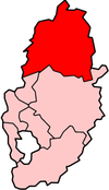
Lage in NottinghamshireStatus District Region East Midlands Verw.grafschaft Nottinghamshire Verwaltungssitz Worksop Fläche 637,86 km² (67.) Einwohner 111.700 (192.) ONS-Code 37UC Website www.bassetlaw.gov.uk Bassetlaw ist ein District in der Grafschaft Nottinghamshire in England. Verwaltungssitz ist die Stadt Worksop. Weitere bedeutende Orte sind Bircotes, Misterton, Ranskill und Retford.
Der Bezirk wurde am 1. April 1974 gebildet und entstand aus der Fusion des Borough of Worksop, des Borough of Retford, des Retford Rural District und dem größten Teil des Worksop Urban District.
Ashfield | Bassetlaw | Broxtowe | Gedling | Mansfield | Newark and Sherwood | Rushcliffe
Wikimedia Foundation.
Schlagen Sie auch in anderen Wörterbüchern nach:
Bassetlaw — Infobox UK district name = Bassetlaw District status = District region = East Midlands admincounty = Nottinghamshire area = Ranked 67th 637.86 km² adminhq = Worksop onscode = 37UC population = Ranked English district rank|ONS=37UC English… … Wikipedia
Bassetlaw — ▪ district, England, United Kingdom district, administrative and historic county of Nottinghamshire, England. The district occupies the northern quarter of the county. The name Bassetlaw previously applied to the parliamentary constituency… … Universalium
Bassetlaw (wapentake) — Bassetlaw was a wapentake (equivalent to a hundred) in the English county of Nottinghamshire. The wapentake covered an area in the north of the county, roughly equivalent to the modern Bassetlaw local government district. The wapentake was… … Wikipedia
Bassetlaw District General Hospital — Bassetlaw Hospital, Worksop, is one of the key hospitals in the Doncaster and Bassetlaw Hospitals NHS Foundation Trust. The Hospital has 300 beds. Each year, the hospital treats around 33,000 patients along with 38,000 emergencies in the A E… … Wikipedia
Bassetlaw (UK Parliament constituency) — UK constituency infobox Name = Bassetlaw Map1 = Bassetlaw Map2 = Nottinghamshire Type = County Year = 1885 Entity = Nottinghamshire County = Nottinghamshire EP = East Midlands MP = John Mann Party = LabourBassetlaw is a parliamentary constituency … Wikipedia
Bassetlaw local elections — One third of Bassetlaw Council is elected each year, followed by one year without election.Political controlLabour 1973 1976No overall control 1976 1979Labour 1979 2004No overall control 2004 2006Conservative 2003 presentCouncil… … Wikipedia
Gamston, Bassetlaw — infobox UK place country = England latitude= 53.28 longitude= 0.94 official name=Gamston population = shire district= Bassetlaw shire county = Nottinghamshire region= East Midlands constituency westminster= Newark post town= RETFORD postcode… … Wikipedia
Upton, Bassetlaw — Upton, Nottinghamshire, DN22, United Kingdom is a location north of Askham and south of Headon.ources [http://www.google.com/maphp?hl=en tab=wl q=Upton,%20Nottinghamshire,%20DN22,%20UK (Google Maps)] … Wikipedia
Trax FM — Radio station name=Trax FM airdate= November 22 1998 frequency=107.1 MHz (Doncaster) 107.9 MHz (Bassetlaw) 11C EMAP South Yorkshire (DAB) Internet share = 14.2% share as of = September 2007 share source =… … Wikipedia
John Mann (politician) — Infobox MP honorific prefix = name = John Mann honorific suffix = constituency MP = Bassetlaw parliament = majority = 10,837 (26.9%) predecessor = Joseph Ashton successor = Incumbent term start = 7 June 2001 term end = birth date = Birth date and … Wikipedia
Bassetlaw

18+
© Academic, 2000-2024
- Kontaktieren Sie uns: Unterstützung, Werbung
Wörterbücher Export, schritte mit PHP, Joomla, Drupal, WordPress, MODx.