- Upper West Region
-
Upper West Region
Obere Westregion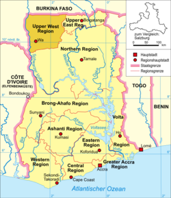
Basisdaten Hauptstadt: Wa Regionalminister: George Hikah Benson Distrikte: 8 ISO 3166-2: GH-UW Fläche Fläche: 18.476 km² Rang in Ghana: 7 Bevölkerung Einwohner: 576.583 (2000) Bevölkerungsdichte: 31,21 Einw./km² (2000) Rang in Ghana: 10 Die Upper West Region (dt. Obere Westregion) ist eine Region Ghanas mit der Hauptstadt Wa.
Inhaltsverzeichnis
Geographie
Die Region liegt im Nordwesten des Landes und grenzt im Norden und Westen an Burkina Faso, im Süden an die Northern Region und im Osten an die Upper East Region.
Politische Gliederung
 Distrikte der Region Upper West
Die Region besteht aus folgenden acht Distrikten:
- Jirapa/Lambussie District
- Lawra District
- Nadowli District
- Sissala East District
- Sissala West District
- Wa East District
- Wa Municipal District
- Wa West District
Siehe auch
Weblink

Ashanti Region | Brong-Ahafo Region | Central Region | Eastern Region | Greater Accra Region | Northern Region | Upper East Region | Upper West Region | Volta Region | Western Region
Wikimedia Foundation.
Schlagen Sie auch in anderen Wörterbüchern nach:
Upper West Region — The Upper West Region of Ghana is located in the northwestern corner of the country and is bordered by Burkina Faso to the north. The capital and largest city is Wa. Other towns include Nandom, Daffiema, Jirapa, Kaleo, Nadowli, Lawra and Tumu.The … Wikipedia
Upper East Region — Obere Ostregion Basisdaten Hauptstadt: Bolgatanga Regionalminister: Alhassan S … Deutsch Wikipedia
Upper River Region — Karte Lage der Region in Gambia Upper River Region … Deutsch Wikipedia
Upper East Region — The Upper East Region of Ghana is located in the northeastern corner of the country and bordered by Burkina Faso to the north and Togo to the east. The capital is Bolgatanga, sometimes shortened to Bolga. Other cities include Bawku and Navrongo.… … Wikipedia
West Region (Cameroon) — Coordinates: 5°30′N 10°30′E / 5.5°N 10.5°E / 5.5; 10.5 … Wikipedia
Región de Malta Majjistral — Capital Ciudad de Birkirkara Entidad … Wikipedia Español
Région du Haut Ghana occidental — 10°20′N 2°15′W / 10.333, 2.25 … Wikipédia en Français
West Virginia Waterways — finds its source at the highland watersheds of the Allegheny Mountains. These watersheds supply drainage to the creeks often passing through deep and narrow hollows. From the hollows, rushing highland streams collect in bottom land brooks and… … Wikipedia
Upper Manhattan — denotes the more northerly region of the New York City Borough of Manhattan. Its southern boundary may be defined anywhere between 59th Street and 155th Street. Between these two extremes lies the most common definitions of Upper Manhattan as… … Wikipedia
Upper Takutu-Upper Essequibo — (Region 10) is a region of Guyana, bordering the region of Potaro Siparuni to the north, the region of East Berbice Corentyne to the east and Brazil to the south and west. It contains the towns Lethem, Isherton, Good Hope and Surama. It is also… … Wikipedia
Upper West Region


18+
© Academic, 2000-2024
- Kontaktieren Sie uns: Unterstützung, Werbung
Wörterbücher Export, schritte mit PHP, Joomla, Drupal, WordPress, MODx.