Upper Hunter Shire

Upper Hunter Shire
Upper Hunter Shire
Australia-Map-NSW-LGA-UpperHunter.png
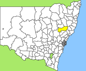
Lage des Upper Hunter Shire in New South Wales
Gliederung
Staat: Australien Australien
Bundesstaat: Flag of New South Wales.svg New South Wales
Verwaltungssitz: Scone
Daten und Zahlen
Fläche: 8.071 km²
Einwohner: 12.976 (2006) [1]
Bevölkerungsdichte: 1,6 Einwohner je km²
-32.05150.61666666667

Das Upper Hunter Shire ist ein lokales Verwaltungsgebiet (LGA) im australischen Bundesstaat New South Wales. Das Gebiet ist 8.071 km² groß und hat etwa 13.000 Einwohner.

Upper Hunter liegt am oberen Ende des Hunter Valley etwa 290 km nördlich der Metropole Sydney. Das Gebiet umfasst 74 Ortsteile und Ortschaften, darunter Aberdeen, Belltrees, Bow, Blandford, Brawboy, Bunnan, Cassilis, Dangarfield, Dartbrook, Upper Dartbrook, Davis Creek, Dry Creek, Ellerston, Glenbawn, Green Creek, Gundy, Gungal, Kars Springs, Kayuga, Omadale, McCullys Gap, Merriwa, Middle Brook, Moobi, Moonan Brook, Moonan Flat, Murrurundi, Owens Gap, Pages River, Parkville, Rossgole, Rouchel, Rouchel Brook, Upper Rouchel, Sandy Creek, Satur, Scone, Scotts Creek, Segenhoe, Stewarts Brook, Timor, Tomalla, Waverly, Wingen und Woolooma. Der Sitz des Shire Councils befindet sich in der Stadt Scone im Zentrum der LGA, wo etwa 4.600 Einwohner leben.

Verwaltung

Der Upper Hunter Shire Council hat neun Mitglieder, die von den Bewohnern der LGA gewählt werden. Upper Hunter ist nicht in Bezirke untergliedert. Aus dem Kreis der Councillor rekrutiert sich auch der Mayor (Bürgermeister) des Councils.

Weblinks

Einzelnachweise

  1. Australian Bureau of Statistics (25. Oktober 2007): Upper Hunter Shire (A) (Local Government Area) (Englisch). 2006 Census QuickStats. Abgerufen am 6. April 2010.

Wikimedia Foundation.

Игры ⚽ Нужен реферат?

Schlagen Sie auch in anderen Wörterbüchern nach:

  • Upper Hunter Shire — Admin ASC 2 Code Orig. name Upper Hunter Shire Country and Admin Code AU.02.17620 AU …   World countries Adminstrative division ASC I-II

  • Upper Hunter Shire Council — Infobox Australian Place | type = lga name = Upper Hunter Shire state = nsw caption = Location in New South Wales pop = 13,376 density = 1.7 area = 8071 est = seat = Scone (130 Liverpool Street) mayor = Barry Rose region = Hunter Valley url =… …   Wikipedia

  • Upper Lachlan Shire — Lage des Upper Lachlan Shire in New South Wales Gliederung …   Deutsch Wikipedia

  • Electoral district of Upper Hunter — Upper Hunter is an electoral district of the Legislative Assembly in the Australian state of New South Wales. It is represented by George Souris of the National Party of Australia.According to the report for the 2004 redistribution of electoral… …   Wikipedia

  • Hunter Region — Infobox Australian Place type = region name = Hunter Region state = nsw imagesize = caption = loc x = 193 loc y = 89 pop = 589,239 pop footnotes = Census 2006 AUS|id=1964|name=Hunter (Statistical Region)|accessdate=2008 01 26|quick=on| ] poprank …   Wikipedia

  • Hunter syndrome — Classification and external resources ICD 10 E76.1 ICD 9 277.5 …   Wikipedia

  • Wakool Shire — Shire of Wakool New South Wales Location in New South Wales Population: 4,427(2009) …   Wikipedia

  • Muswellbrook Shire — New South Wales Location in New South Wales Population …   Wikipedia

  • Dungog Shire — New South Wales Location in New South Wales Population …   Wikipedia

  • Muswellbrook Shire Council — Infobox Australian Place | type = lga name = Muswellbrook Shire caption = Location in New South Wales state = New South Wales region = Hunter Valley area = 3406 est = seat = Muswellbrook (Maitland Street)cite web title=Muswellbrook Shire Council… …   Wikipedia

Share the article and excerpts

Direct link
Do a right-click on the link above
and select “Copy Link”