U.S. Highway 118

U.S. Highway 118
Straßenschild des U.S. Highways 151
Karte
Karte des U.S. Highways 151
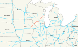
Basisdaten
Gesamtlänge:  337 mi/542 km
Eröffnung:  1926
Bundesstaaten:  Iowa
Wisconsin
Anfangspunkt:  Straßenschild der I-80 I-80 in Williamsburg, Iowa
Endpunkt:  US 10 in Manitowoc, Wisconsin

Der U.S. Highway 151 (kurz US 151) ist ein United States Highway in den US-Bundesstaaten Iowa und Wisconsin.

Der Highway beginnt an der Interstate 80 in Williamsburg und endet am U.S. Highway 10 in Manitowoc.

Inhaltsverzeichnis

Verlauf

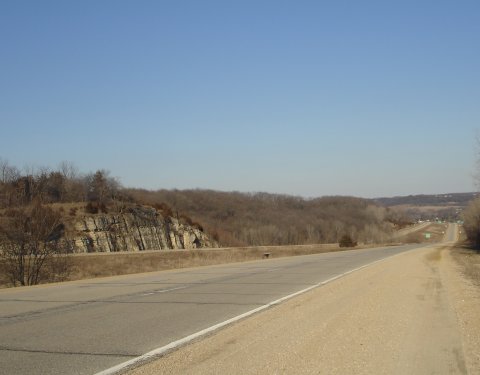
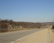
Der US 151 8 Meilen südlich von Dubuque

Iowa

Der Highway beginnt in Iowa an der Interstate 80 in Williamsburg etwa 32 Kilometer von Iowa City entfernt. Danach verläuft er Richtung Nordosten nach Cedar Rapids, wo sich der Highway mit dem U.S. Highway 30 kreuzt. Auf dem Weg nach Dubuque tangiert er die Städte Anamosa, Monticello und Cascade. In Dubuque kreuzt er sich dann mit dem U.S. Highway 20.

Wisconsin

Der Highway überquert die Grenze an der Ecke wo Iowa, Illinois und Wisconsin aneinander grenzen. Danach verläuft er Richtung Dodgeville. In Madison kreuzt er sich mit der Interstate 90. In Fond du Lac kreuzt er sich dann noch mit dem U.S. Highway 41. Er endet schließlich am U.S. Highway 10 in Manitowoc.

Siehe auch

Weblinks


Wikimedia Foundation.

Игры ⚽ Нужно сделать НИР?

Schlagen Sie auch in anderen Wörterbüchern nach:

  • Highway 118 (Ontario) — Infobox road province=ON type=Hwy route=118 alternate name= maint=the Ministry of Transportation length km=127.8 length ref=Ministry of Transportation of Ontario, [http://www.raqsa.mto.gov.on.ca/techpubs/TrafficVolumes.nsf/tvweb 2004 Annual… …   Wikipedia

  • Nova Scotia Highway 118 — Highway 118 Lakeview Drive Route information Maintained by Nova Scotia Department of Transportation and Infrastructure Renewal …   Wikipedia

  • Minnesota State Highway 118 — was a highway route number in the U.S. state of Minnesota that was used previously during two different time periods. Once during the 1930s and once during the 1990s. The 1930s route was located in Isanti and Kanabec counties in east central… …   Wikipedia

  • British Columbia Highway 118 — Infobox road province=BC type=Hwy route=118 maint= length km= length round= length ref= established= direction a= starting terminus= junction= direction b= ending terminus= previous type=Hwy previous route=101 next type=Hwy next route=395Highway… …   Wikipedia

  • Texas State Highway 118 — Infobox TX State Highway type=State route=118 length mi=155.27Texas Department of Transportation, [http://www.dot.state.tx.us/tpp/hwy/sh/sh0118.htm] ] length km=249.88 formed=by 1933 dir1=North dir2=South from= junction= to= previous type=State… …   Wikipedia

  • Ontario Highway 118 — Highway 118 Route information Maintained by the Ministry of Transportation Length: 127.8 km[ …   Wikipedia

  • Wisconsin Highway 118 — Infobox road state=WI type=WI route=118 length mi=6.86 length ref=cite web | last = Bessert | first = Chris | title =Wisconsin Highways: Highways 110 119 (Highway 118) | work =Wisconsin Highways | url… …   Wikipedia

  • National Highway 118 (India) — 118 …   Wikipedia

  • Highway 11 (Ontario) — Infobox road province=ON type=Hwy route=11 alternate name= map custom=yes length km= length ref=Ministry of Transportation of Ontario, [http://www.raqsa.mto.gov.on.ca/techpubs/TrafficVolumes.nsf/tvweb 2004 Annual Average Daily Traffic] ] length… …   Wikipedia

  • Highway 10 (British Columbia) — Highway 10 bildet eine Verbindung zwischen Delta und Langley. Der Beginn des Highways liegt dabei am Highway 91 und endet am Highway 1, dem Trans Canada Highway.[1] Ursprünglich begann der Highway in der Ortsmitte von Delta, um den Verkehr um… …   Deutsch Wikipedia

Share the article and excerpts

Direct link
Do a right-click on the link above
and select “Copy Link”