- Tunbridge Wells (Borough)
-
Borough of Tunbridge Wells 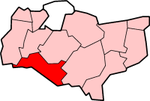
Lage in KentStatus Borough Region South East England Verw.grafschaft Kent Verwaltungssitz Tunbridge Wells Fläche 331,33 km² (148.) Einwohner 105.600 (212.) ONS-Code 29UQ Website www.tunbridgewells.gov.uk Tunbridge Wells ist ein Verwaltungsbezirk mit dem Status eines Borough in der Grafschaft Kent in England. Er ist nach dem Verwaltungssitz Tunbridge Wells benannt, in dem knapp die Hälfte der Bevölkerung lebt. Das Borough ist in zehn Kreise (wards) aufgeteilt. Acht davon liegen in der Stadt selbst, die übrigen umfassen die umliegenden Dörfer. Dazu gehören unter anderem Cranbrook, Paddock Wood, Pembury und Southborough.
Der Bezirk wurde am 1. April 1974 gebildet und entstand aus der Fusion des Municipal Borough Royal Tunbridge Wells, des Urban District Southborough, des Rural District Cranbrook und des größten Teils des Rural District Tonbridge.
Tunbridge Wells (borough) — Tunbridge Wells is a local government district and borough in Kent, England. It takes its name from its main town, Royal Tunbridge Wells.The district was formed on April 1, 1974, by the merger of the municipal borough of Royal Tunbridge Wells… … Wikipedia
Tunbridge Wells (borough) — Borough de Tunbridge Wells District dans le Kent Géographie Status: Borough Région: Angleterre du Sud Est Comté … Wikipédia en Français
Tunbridge Wells (disambiguation) — Tunbridge Wells is a town in west Kent in England, on the northern edge of the Weald.Tunbridge Wells may also refer to:* Tunbridge Wells (borough), a local government district and borough in Kent, England * Tunbridge Wells (UK Parliament… … Wikipedia
Tunbridge Wells West railway station — Infobox UK disused station name = Tunbridge Wells West gridref = TQ578384 caption = manager = London, Brighton and South Coast Railway owner = Southern Railway Southern Region of British Railways Network SouthEast Spa Valley Railway locale =… … Wikipedia
Tunbridge Wells — 51.1288888888890.26083333333332 Koordinaten: 51° 8′ N, 0° 16′ O … Deutsch Wikipedia
Tunbridge Wells (UK Parliament constituency) — UK constituency infobox Name = Tunbridge Wells Map1 = TunbridgeWells Map2 = Kent Type = County Year = 1974 Entity = Kent County = Kent EP = South East England MP = Greg Clark Party = ConservativeTunbridge Wells is a parliamentary constituency… … Wikipedia
Tunbridge Wells railway station — Infobox UK station name = Tunbridge Wells code = TBW manager = Southeastern locale = Tunbridge Wells borough = Tunbridge Wells usage0405 = 3.149 usage0506 = 3.264 platforms = 2 start = 25 November 1846Tunbridge Wells railway station serves… … Wikipedia
Tunbridge Wells — (spr. tönnbriddsch), Stadt (municipal borough) in der engl. Grafschaft Kent, 8 km südlich von Tonbridge, nächst Bath der älteste Badeort Englands, aber mehr wegen seiner guten Luft als seiner Stahlquellen besucht, liegt malerisch auf drei Hügeln … Meyers Großes Konversations-Lexikon
Royal Tunbridge Wells — Tunbridge Wells redirects here. For other uses, see Tunbridge Wells (disambiguation). Coordinates: 51°08′00″N 0°15′53″E / 51.1332°N 0.2647°E … Wikipedia
Royal Tunbridge Wells — DEC … Deutsch Wikipedia
Tunbridge Wells (Borough)

18+
© Academic, 2000-2024
- Kontaktieren Sie uns: Unterstützung, Werbung
Wörterbücher Export, schritte mit PHP, Joomla, Drupal, WordPress, MODx.