- Timiskaming District
-
Timiskaming District 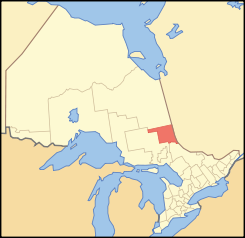
Lage des Timiskaming District in OntarioProvinz Ontario Verwaltungssitz Temiskaming Shores Fläche 13.280,06 km² Einwohner (2001) 34.442 Bevölkerungsdichte 2,6 Ew./km² Der Timiskaming District ist ein Verwaltungsbezirk im Nordosten der kanadischen Provinz Ontario. Hauptort ist Temiskaming Shores. Die Einwohnerzahl beträgt 34.442 (2001), die Fläche 13.280,06 km², was einer Bevölkerungsdichte von 2,6 Einwohnern je km² entspricht. Der Bezirk entstand 1912 aus Teilen des Algoma District, des Nipissing District und des Sudbury District. 1921 wurde ein Teil an den neu gebildeten Cochrane District abgetreten.
Gliederung
Gemeinden:
- Armstrong
- Brethour
- Casey
- Chamberlain
- Charlton and Dack
- Cobalt
- Coleman
- Englehart
- Evanturel
- Gauthier
- Harley
- Harris
- Hilliard
- Hudson
- James
- Kerns
- Kirkland Lake
- Larder Lake
- Latchford
- Matachewan
- McGarry
- Temiskaming Shores
- Thornloe
Reservat:
- Matachewan 72
Gemeindefreie Gebiete:
- Timiskaming, Unorganized, East Part
- Timiskaming, Unorganized, West Part
Weblinks

Einstufige Gemeinden: Brant | Brantford | Chatham-Kent | Greater Sudbury | Haldimand | Hamilton | Kawartha Lakes | Norfolk | Ottawa | Prince Edward | Toronto
Regionalgemeinden: Durham | Halton | Muskoka | Niagara | Oxford | Peel | Waterloo | York
Countys: Bruce | Dufferin | Elgin | Essex | Frontenac | Grey | Haliburton | Hastings | Huron | Lambton | Lanark | Leeds and Grenville | Lennox and Addington | Middlesex | Northumberland | Perth | Peterborough | Prescott and Russell | Renfrew | Simcoe | Stormont, Dundas and Glengarry | Wellington
Distrikte: Algoma | Cochrane | Kenora | Manitoulin | Nipissing | Parry Sound | Rainy River | Sudbury | Thunder Bay | Timiskaming
Wikimedia Foundation.
Schlagen Sie auch in anderen Wörterbüchern nach:
Timiskaming District — District Location of Timiskaming District in Ontario … Wikipedia
Timiskaming District, Ontario — Timiskaming is a district and census division in Northeastern Ontario in the Canadian province of Ontario. The district was created in 1912 from parts of Algoma, Nipissing, and Sudbury districts. In 1921, Cochrane District was created from parts… … Wikipedia
List of secondary highways in Timiskaming District — This is a list of secondary highways in Timiskaming District, most of which serve as logging roads or provide access to the isolated and sparsely populated areas in the Timiskaming District of northeastern Ontario. Contents 1 Highway 558 2… … Wikipedia
Unorganized West Timiskaming District — Unorganized Timiskaming West Part Unorganized territory … Wikipedia
Montreal River (Timiskaming District, Ontario) — Coordinates: 47°08′20″N 79°27′15″W / 47.13889°N 79.45417°W / 47.13889; 79.45417 … Wikipedia
Moore Creek (Timiskaming District, Ontario) — For other places with the same name, see Moore Creek (disambiguation). Coordinates: 47°28′08″N 79°38′52″W / 47.46889°N 79.64778°W … Wikipedia
Cleaver Lake (Timiskaming District, Ontario) — For other lakes named Cleaver Lake, see Cleaver Lake. Cleaver Lake Location Timiskaming District, Ontario Coordinates … Wikipedia
Timiskaming (electoral district) — Timiskaming (later known as Timiskaming French River ) was a federal electoral district in the northeastern part of Ontario, Canada, that was represented in the Canadian House of Commons from 1917 to 1925, and from 1935 to 1997. It was created in … Wikipedia
Timiskaming — is a word from the Algonquin Temikami or Temikaming , meaning deep waters . Alternate spellings include: Temiskaming, Témiscaming, Témiscamingue. The word Temagami comes from the same root. It refers to the following places, all in Canada:* Lake… … Wikipedia
Timiskaming South — was a Canadian electoral district represented in the Canadian House of Commons from 1925 to 1935. It was located in the northeastern part of the province of Ontario. It was created in 1924 from parts of Nipissing and Timiskaming ridings. It… … Wikipedia
Timiskaming District

18+
© Academic, 2000-2024
- Kontaktieren Sie uns: Unterstützung, Werbung
Wörterbücher Export, schritte mit PHP, Joomla, Drupal, WordPress, MODx.