- Teraina
-
Teraina NASA-Foto von Teraina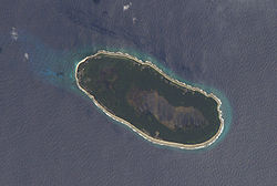
Gewässer Pazifischer Ozean Inselgruppe Line Islands Geographische Lage 4° 41′ 0″ N, 160° 22′ 40″ W4.6833333333333-160.37777777778Koordinaten: 4° 41′ 0″ N, 160° 22′ 40″ W 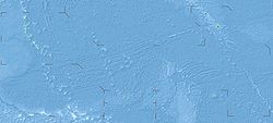

Länge 7 km Breite 3 km Fläche 14,2 km² Einwohner 1.155 (2005)
81 Einw./km²Hauptort Tangkore Ein Maneaba, typisches Versammlungshaus einer Sippe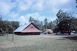
Teraina oder Washington Island, in neuerer Schreibung auch Teeraina, ist ein polynesisches, zum Staat Kiribati gehörendes Atoll. Es ist Teil der im zentralen Pazifischen Ozean gelegenen Inselkette der Line Islands. In der Vergangenheit wurde Teraina neben Washington Island auch New York oder Prospect genannt.
Inhaltsverzeichnis
Geographie
Das Atoll liegt 523 km nördlich des Äquators, 141 km nordwestlich von Tabuaeran (Fanning Island) und 223 km südöstlich von Palmyra. Es handelt es sich um ein sogenanntes gehobenes Atoll, bei welchem die Lagune zwar mittlerweile komplett vom Korallenring umschlossen, aber noch nicht vollständig ausgetrocknet ist. In diesem Fall wird die Lagune als Binnensee zur Landfläche gezählt. Teraina ist etwa 7 km lang und bis zu 3 km breit, und weist dabei eine Fläche von 14,2 km² auf. Die sandige Insel ist fast vollständig von einem Korallenriff umgeben, das Anlanden mit Booten ist nur an der Westspitze in der Nähe des Hauptortes möglich und gilt als schwierig.
Auf der Insel leben etwa 1.150 Einwohner, deren Haupteinkommensquelle die Produktion von Kopra ist. Sie verteilen sich auf neun Siedlungen.
Die einzelnen Siedlungen gegen den Uhrzeigersinn von Nordosten aus:
Siedlung Einwohnerzahl
(Zählung 2005)[1]Abaiang 91 Kauamwemwe 106 Uteute 72 Kaaitara 34 Tangkore (Hauptort) 203 Matanibike 191 Arabata 190 Mwakeitari 92 Onauea 176 Teraina gesamt 1.155 Geschichte
Das Atoll wurde am 12. Juni 1798 vom US-amerikanischen Forscher Edmund Fanning (1769-1841) gesichtet, der sie nach dem ersten Präsidenten der USA, George Washington, benannte. Unter Berufung auf den 1856 verabschiedeten Guano Islands Act wurde Washington zwar von den Vereinigten Staaten beansprucht, jedoch nicht in Besitz genommen. Im Jahre 1889 wurde die tropische Insel vom Britischen Empire annektiert und der Kolonie Gilbert- und Ellice-Inseln zugeordnet. Seit 1979 gehört sie zum Inselstaat Kiribati und wird offiziell Teraina genannt.
Weblinks
 Commons: Teraina – Sammlung von Bildern, Videos und Audiodateien
- Teraina auf oceandots.com (englisch)
- Detaillierte Karte
- Jane's Ocenia Page - Washington Island (englisch)
Einzelnachweise
- ↑ Volkszählung 2005 (PDF, englisch)
Inseln und Atolle der Line IslandsNordgruppe: Kingmanriff | Kiritimati | Palmyra-Atoll | Tabuaeran | Teraina
Zentralgruppe: Jarvis | Malden | Starbuck | (Filipporiff)
Südgruppe: Caroline-Atoll | Flint | Vostok
Wikimedia Foundation.
Schlagen Sie auch in anderen Wörterbüchern nach:
Teraina — Teraina, also known as Washington Island (both names are constitutional [POK (2007)] ) is a coral atoll in the central Pacific Ocean, part of the Northern Line Islands which belong to Kiribati. Obsolete names of Teraina are Prospect Island and… … Wikipedia
Teraina — Washington Island (en) Image satellite de Teraina. Géographie Pays … Wikipédia en Français
Teraina — Teraina, eine der Linieninseln, Kiribati … Universal-Lexikon
Teraina — Casa de Reunión de los hombres (noviembre de 1968). Teraina, también conocido como Isla Washington (ambos nombres son oficiales), es un atolón coralino situado en el océano Pacífico central. Forma parte de las Islas de la Línea pertenecientes a… … Wikipedia Español
Teraina — Admin ASC 2 Code Orig. name Teraina Country and Admin Code KI.02.TE KI … World countries Adminstrative division ASC I-II
Teraina Island — ▪ island, Kiribati formerly called Washington Island or Prospect Island coral atoll of the Northern Line Islands, part of Kiribati, in the west central Pacific Ocean. With a circumference of 9 miles (14 km), it rises to about 10 feet (3… … Universalium
Teraina — or formerly Washington geographical name island W Pacific in the Line Islands population 437 … New Collegiate Dictionary
Washington (Kiribati) — Teraina Teraina Washington Island (en) Image satellite de Teraina. Géographie Pays … Wikipédia en Français
Île Washington — Teraina Teraina Washington Island (en) Image satellite de Teraina. Géographie Pays … Wikipédia en Français
Washington-Insel — Vorlage:Infobox Insel/Wartung/Höhe fehlt Teraina NASA Foto von Teraina Gewässer Pazifischer Ozean Inselgruppe … Deutsch Wikipedia
- Kontaktieren Sie uns: Unterstützung, Werbung
Teraina


18+
© Academic, 2000-2024
Wörterbücher Export, schritte mit PHP, Joomla, Drupal, WordPress, MODx.