Tenterfield Shire

Tenterfield Shire
Shire of Tenterfield
Australia-Map-NSW-LGA-Tenterfield.png
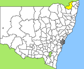
Lage des Tenterfield Shire in New South Wales
Gliederung
Staat: Australien Australien
Bundesstaat: Flag of New South Wales.svg New South Wales
Verwaltungssitz: Tenterfield
Daten und Zahlen
Fläche: 7.332 km²
Einwohner: 6.534 (2006) [1]
Bevölkerungsdichte: 0,9 Einwohner je km²
Wards: 5
-29.033333333333152.01666666667

Tenterfield Shire ist ein lokales Verwaltungsgebiet (LGA) im australischen Bundesstaat New South Wales. Das Gebiet ist 7.332 km² groß und hat etwa 6.800 Einwohner.

Tenterfield liegt im äußersten Nordosten des Staates etwa 720 km nördlich der Metropole Sydney und 270 km südwestlich von Brisbane. Das Gebiet umfasst 104 Ortsteile und Ortschaften, darunter Bismuth, Black Swamp, Bolivia, Boonoo Boonoo, Bryans Gap, Bungulla, Clifton, Deepwater, Leechs Gully, Legume, Liston, Mingoola, Mole River, Sandy Flat, Sandy Hill, Silent Grove, Sunnyside, The Scrub, Stannum, Steinbrook, Tarban, Tenterfield, Torrington und Tungsten. Der Sitz des Shire Councils befindet sich in der Stadt Tenterfield im Zentrum der LGA, wo etwa 3.100 Einwohner leben.

Verwaltung

Der Tenterfield Shire Council hat zehn Mitglieder, die von den Bewohnern der fünf Wards gewählt werden (je zwei aus den Wards A bis E). Diese fünf Bezirke sind unabhängig von den Ortschaften festgelegt. Aus dem Kreis der Councillor rekrutiert sich auch der Mayor (Bürgermeister) des Councils.

Weblinks

Einzelnachweise

  1. Australian Bureau of Statistics (25. Oktober 2007): Tenterfield (A) (Local Government Area) (Englisch). 2006 Census QuickStats. Abgerufen am 6. April 2010.

Wikimedia Foundation.

Игры ⚽ Нужно решить контрольную?

Schlagen Sie auch in anderen Wörterbüchern nach:

  • Tenterfield Shire Council — Infobox Australian Place | type = lga name = Tenterfield Shire caption = Location in NSW state=New South Wales region=New England area=7332 seat=Tenterfield (247 Rouse Street)cite web title=Tenterfield Shire Council publisher = Department of… …   Wikipedia

  • Tenterfield — Rouse Street (New England Hwy), Tenterfield, NSW Staat …   Deutsch Wikipedia

  • Tenterfield, New South Wales — Infobox Australian Place | type = town name = Tenterfield state = nsw caption = Location of Tenterfield in New South Wales (red) lga = Tenterfield Shire Council postcode = 2372 est = 1851 pop = 3,172 elevation= 850 maxtemp = 21.4 mintemp = 8.1… …   Wikipedia

  • Shire of Stanthorpe — Infobox Australian Place | type = lga name = Shire of Stanthorpe state = qld imagesize= 135 caption = Location within Queensland pop = 9,818 area = 2669 est = seat = Stanthorpe region = logosize = 100 url = http://www.stanthorpe.qld.gov.au/ near… …   Wikipedia

  • Shire of Glengallan — Infobox Australian Place | type = lga name = Shire of Glengallan state = qld imagesize= 135 caption = Location within Queensland pop = 3,966 pop footnotes = (1991 census) [cite book|title=2730.3 Census counts for small areas :… …   Wikipedia

  • Shire of Boonah — Infobox Australian Place | type = lga name = Shire of Boonah state = qld imagesize= 135px caption = Location within Queensland area = 1921.6 est = 1880 seat = Boonah pop = 8,770 pop footnotes = (2006 census) [Census 2006 AUS | id = LGA30800 |… …   Wikipedia

  • Shire of Warwick — Infobox Australian Place | type = lga name = Shire of Warwick state = qld imagesize= 135 caption = Location within Queensland pop = 20,609 (2001 census) area = 4429 est = seat = Warwick region = Darling Downs logosize = 92 url =… …   Wikipedia

  • Shire of Rosenthal — Infobox Australian Place | type = lga name = Shire of Rosenthal state = qld imagesize= 135 caption = Location within Queensland pop = 2,241 pop footnotes = (1991 census) [cite book|title=2730.3 Census counts for small areas :… …   Wikipedia

  • Shire of Inglewood — Infobox Australian Place | type = lga name = Shire of Inglewood state = qld imagesize= 135 caption = Location within Queensland pop = 2,610 (2001 census) area = est = seat = Inglewood region = logosize = 143 url = http://www.inglewood.qld.gov.au/ …   Wikipedia

  • Wakool Shire — Shire of Wakool New South Wales Location in New South Wales Population: 4,427(2009) …   Wikipedia

Share the article and excerpts

Direct link
Do a right-click on the link above
and select “Copy Link”