Baltimore County (Maryland)

Baltimore County (Maryland)
Verwaltung
US-Bundesstaat: Maryland
Verwaltungssitz: Towson
Adresse des
Verwaltungssitzes:
Gründung: 1659
Gebildet aus:
Vorwahl: {{{VORWAHL}}}
Demographie
Einwohner: 786.113  (2000)
Bevölkerungsdichte: 507,2 Einwohner/km²
Geographie
Fläche gesamt: 1.766 km²
Wasserfläche: 216 km²
Karte
Karte von Baltimore County innerhalb von Maryland

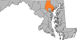
Baltimore County ist ein County im US-Bundesstaat Maryland, Vereinigte Staaten. Hier leben 786.113 Menschen. Der Sitz der Countyverwaltung (County Seat) ist in Towson.

Geographie

Das County hat eine Fläche von 1.766 km², davon sind 1.550 km² Land und 216 (12,23 %) sind Wasser.

Nachbar-Countys

Census-designated places

  • Arbutus
  • Bowleys Quarters
  • Carney
  • Catonsville
  • Cockeysville
  • Dundalk
  • Edgemere
  • Essex
  • Garrison
  • Hampton
  • Kingsville
  • Lansdowne-Baltimore Highlands
  • Lochearn
  • Lutherville-Timonium
  • Mays Chapel
  • Middle River
  • Milford Mill
  • Overlea
  • Owings Mills
  • Parkville
  • Perry Hall
  • Pikesville
  • Randallstown
  • Reisterstown
  • Rosedale
  • Rossville
  • Towson
  • White Marsh
  • Woodlawn

39.399998-76.5999957Koordinaten: 39° 24′ N, 76° 36′ W


Wikimedia Foundation.

Игры ⚽ Поможем написать курсовую

Schlagen Sie auch in anderen Wörterbüchern nach:

  • Baltimore County, Maryland — Infobox U.S. County county = Baltimore County state = Maryland founded year = 1659 seat wl = Towson area total sq mi =682 area land sq mi =599 area water sq mi =83 area percentage = 12.23% census estimate yr = 2005 pop = 786113 density km2 =487… …   Wikipedia

  • List of roads in Baltimore County, Maryland — Contents A · B · C · D · E · F · G · H · I · J · K · …   Wikipedia

  • National Register of Historic Places listings in Baltimore County, Maryland — Location of Baltimore County in Maryland This is a list of the National Register of Historic Places listings in Baltimore County, Maryland. This is intended to be a complete list of the properties and districts on the National Register of… …   Wikipedia

  • Woodlawn, Baltimore County, Maryland — Woodlawn   Census designated place   …   Wikipedia

  • Ruxton-Riderwood, Baltimore County, Maryland — Ruxton and Riderwood are unincorporated areas in Baltimore County, Maryland. They are sometimes considered a part of Towson and are part of Towson s census area.The boundaries of Ruxton have been established largely by local custom. Both the… …   Wikipedia

  • Jerusalem, Baltimore County, Maryland — Jerusalem   Unincorporated community   …   Wikipedia

  • Germantown, Baltimore County, Maryland — Germantown is an unincorporated community located in Baltimore County, Maryland. It is located at coord|39|25|0|N|76|27|32|W| …   Wikipedia

  • Baltimore Highlands, Maryland — Baltimore Highlands is a unincorporated coummunity in southern Baltimore County, Maryland; just south of Baltimore city. The census combines the communities of Baltimore Highlands and Lansdowne (which are 1.5 miles apart… …   Wikipedia

  • Baltimore County Public Library — (BCPL), established in 1948, is a public library system located in central Maryland. BCPL serves Baltimore County, Maryland which surrounds but does not include the city of Baltimore, Maryland. Baltimore City is served by the Enoch Pratt Free… …   Wikipedia

  • Baltimore Corner, Maryland — Baltimore Corner, Maryland, is a unincorporated community on the Eastern Shore of the U.S. state of Maryland, in Caroline County. It is near the Queen Anne s County line at the intersection of Maryland Route 313 and 312. It is unrelated to and… …   Wikipedia

Share the article and excerpts

Direct link
Do a right-click on the link above
and select “Copy Link”