- Tatebayashi
-
Tatebayashi-shi
館林市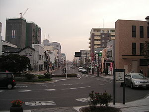
Geographische Lage in Japan 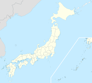

Region: Kantō Präfektur: Gunma Koordinaten: 36° 15′ N, 139° 33′ O36.244722222222139.54194444444Koordinaten: 36° 14′ 41″ N, 139° 32′ 31″ O Basisdaten Fläche: 60,98 km² Einwohner: 78.126
(1. Juli 2011)Bevölkerungsdichte: 1.281 Einwohner je km² Gemeindeschlüssel: 10207-5 Symbole Baum: Japanische Schwarzkiefer Blume: Rhododendron kaempferi var. kaempferi Vogel: Fleckschnabelente Rathaus Adresse: Tatebayashi City Hall
1-1, Shiro-machi
Tatebayashi-shi
Gunma 374-8501Webadresse: http://www.city.tatebayashi.gunma.jp Lage Tatebayashis in der Präfektur Gunma 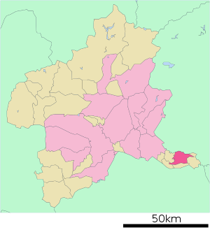
Tatebayashi (jap. 館林市, -shi) ist eine Stadt in der Präfektur Gunma auf Honshū, der Hauptinsel von Japan.
Inhaltsverzeichnis
Geographie
Tatebayashi liegt etwa 55 km nördlich von Tokio am Fluss Watarase in der Kantō-Ebene.
Verkehr
- Straße:
- Tōhoku-Autobahn
- Nationalstraße 122, nach Tōkyō oder Nikkō
- Nationalstraße 354
- Zug:
- Tobū Isesaki-Linie
Sehenswürdigkeiten
- Der Morin-ji (茂林寺) ist der berühmteste Tempel der Stadt.
Söhne und Töchter der Stadt
- Tayama Katai (Schriftsteller)
- Chiaki Mukai (erste japanische Astronautin)
Angrenzende Städte und Gemeinden
- Präfektur Gunma
- Ōra
- Meiwa
- Chiyoda
- Itakura
- Präfektur Tochigi
Weblinks
 Commons: Tatebayashi – Sammlung von Bildern, Videos und Audiodateien
 Gemeinden und Landkreise in der Präfektur Gunma
Kreisfreie Städte (shi): Annaka | Fujioka | Isesaki | Kiryū | Maebashi (Verwaltungssitz) | Midori | Numata | Ōta | Shibukawa | Takasaki | Tatebayashi | Tomioka
Agatsuma-gun: Higashiagatsuma | Kusatsu | Naganohara | Nakanojō | Takayama | Tsumagoi | Kanra-gun: Kanra | Nammoku | Shimonita | Kitagumma-gun: Shintō | Yoshioka | Ōra-gun: Chiyoda | Itakura | Meiwa | Ōizumi | Ōra | Sawa-gun: Tamamura | Tano-gun: Kanna | Ueno | Tone-gun: Katashina | Kawaba | Minakami | Shōwa
Wikimedia Foundation.
Schlagen Sie auch in anderen Wörterbüchern nach:
Tatebayashi — Original name in latin Tatebayashi Name in other language Tatebayashi State code JP Continent/City Asia/Tokyo longitude 36.25 latitude 139.53333 altitude 28 Population 81274 Date 2012 01 19 … Cities with a population over 1000 database
Tatebayashi — ▪ Japan city, Gumma ken (prefecture), Honshu, Japan. It lies in the northern Kantō Plain along the Isesaki line of the Tōbu railway, north of Tokyo. Founded in the 16th century as a castle town, it developed as a commercial centre for the… … Universalium
Tatebayashi, Gunma — Japanese city Name = Tatebayashi JapaneseName = 館林市 Region = Kantō Prefecture = Gunma Prefecture District = Area km2 = 60.98 Population = 79,753 PopDate = 2003 Density km2 = 1307.86 Coords= coord|36|15|N|139|33|E|region:JP type:city Latitude =… … Wikipedia
Tatebayashi Station — nihongo|Tatebayashi Station|館林駅|Tatebayashi eki is the name of a passenger service station of the Tobu Isesaki Line, which is operated by Tobu Railway company, located in Tatebayashi, Gunma Prefecture, Japan. History The first station was opened… … Wikipedia
Tatebayashi Domain — The nihongo|Tatebayashi Domain|館林藩|Tatebayashi han was a Japanese domain of the Edo period, located in Kōzuke Province (modern day Tatebayashi, Gunma).List of lords*Sakakibara clan (Fudai; 100,000 >110,000 koku)#Yasumasa #Yasukatsu… … Wikipedia
Tatebayashi-shi — Admin ASC 2 Code Orig. name Tatebayashi shi Country and Admin Code JP.10.7453849 JP … World countries Adminstrative division ASC I-II
6663 Tatebayashi — Infobox Planet minorplanet = yes width = 25em bgcolour = #FFFFC0 apsis = name = Tatebayashi symbol = caption = discovery = yes discovery ref = discoverer = T. Kobayashi discovery site = Oizumi discovered = February 12, 1993 designations = yes mp… … Wikipedia
Tōbu Sano Line — The nihongo|Tōbu Sano Line|東武佐野線|Tōbu Sano sen, operated by the private Tōbu Railway company, runs from Tatebayashi Station located in Tatebayashi city, Gunma Prefecture to Kuzū Station located in Sano, Tochigi Prefecture. In February,2005 the… … Wikipedia
Chiaki Mukai — NASDA/JAXA Astronaut Nationality Japanese Born May 6, 1952 (1952 05 06) … Wikipedia
Ōta Station (Gunma) — Ōta Station 太田駅 Elevated station building Location Prefecture … Wikipedia
- Straße:
Tatebayashi


18+
© Academic, 2000-2024
- Kontaktieren Sie uns: Unterstützung, Werbung
Wörterbücher Export, schritte mit PHP, Joomla, Drupal, WordPress, MODx.