- Tanaga Island
-
Tanaga Island Mount Tanaga auf Tanaga Island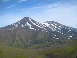
Gewässer Pazifischer Ozean Inselgruppe Aleuten Geographische Lage 51° 48′ N, 177° 57′ W51.8-177.951806Koordinaten: 51° 48′ N, 177° 57′ W 

Länge 40 km Breite 32 km Fläche 530 km² Höchste Erhebung Mount Tanaga
1.806 mEinwohner (unbewohnt) Topographische karte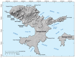
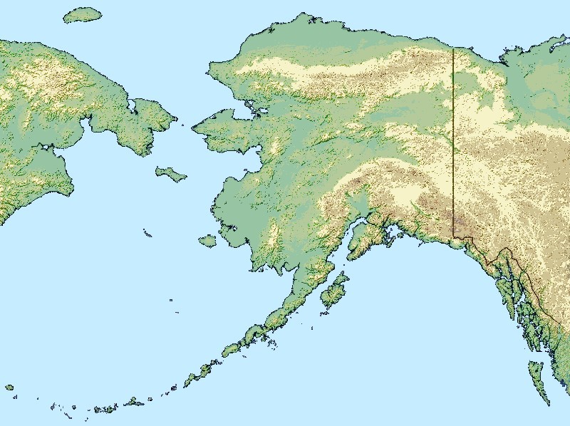
Tanaga Island ist eine Insel im Westen der Andreanof Islands, welche ihrerseits im Südwesten der Aleuten liegen.
Die zum US-Bundesstaat Alaska zählende, unbewohnte Insel ist etwa 40 km lang und zwischen 4 und 32 km breit. Im Nordwesten der Insel liegt der 1806 m hohe Vulkan Mount Tanaga, dessen bisher letzter Ausbruch 1914 stattgefunden hat.
Weblinks
 Commons: Tanaga Island – Sammlung von Bildern, Videos und Audiodateien
- Information zum Vulkan Mount Tanaga (engl.)
- Tanaga Island im Global Volcanism Program der Smithsonian Institution (englisch)
Inseln und Inselgruppen der Andreanof IslandsAdak | Agligadak | Amatigis Islands | Amlia | Anagaksik | Argonne | Asuksak | Atka | Aziak | Barbara | Black | Bobrof | Bolshoi Islands | Box | Castle | Chaika Rock | Channel | Chisak | Chugul | Cone | Cormorant | Crone | Delarof Islands | Dora | Eddy | Elf | Fenimore Rock | Gramp Rock | Great Sitkin | Green | Igitkin | Ikiginak | Ina | Kagalaska | Kanaga | Kanu | Kasatochi | Koniuji | Little Tanaga | North | Oglodak | Plum | Ringgold | Sadatanek | Sagchudak | Sagigik | Salt | Sea Parrot | Seguam | Silak | South | Staten | Tagadak | Tagalak | Tanaga | Tanaklek | The Signals | The Three Sisters | Tidgituk | Umak | Uyak | Whip
Wikimedia Foundation.
Schlagen Sie auch in anderen Wörterbüchern nach:
Tanaga Island — Location map Alaska label= lat=52.0 long= 181.95 position=right width=250 float=right caption=Location in AlaskaTanaga Island (Tanax̂ax [Bergsland, K Aleut Dictionary Fairbanks: Alaska Native Language Center, 1994] in Aleut) is an island in the… … Wikipedia
Tanaga Island — Sp Tanãgos salà Ap Tanaga Island L Aleutuose, Andrejanovo ss., JAV (Aliaska) … Pasaulio vietovardžiai. Internetinė duomenų bazė
Little Tanaga Island — Vorlage:Infobox Insel/Wartung/Fläche fehlt Little Tanaga Island NASA Bild von Little Tanaga Island Gewässer … Deutsch Wikipedia
Little Tanaga Island — Location map Alaska label= lat=51.94361 long= 179.60417 position=right width=250 float=right caption=Location in AlaskaLittle Tanaga Island (Tanagax̂ [Bergsland, K Aleut Dictionary Fairbanks: Alaska Native Language Center, 1994] in Aleut) is an… … Wikipedia
Tanaga (volcano) — Infobox Mountain Name = Tanaga Photo = Caption = Elevation = 5,924 ft (1,806 m) Location = Tanaga Island, Alaska, USA Range = Aleutian Range Prominence = Coordinates = Topographic Type = stratovolcano Age = Last eruption = 1914 First ascent =… … Wikipedia
Kanaga Island — ▪ island, Alaska, United States one of the Andreanof Islands of the Aleutian Islands chain, southwestern Alaska, U.S. The uninhabited island measures 30 miles (50 km) long and 4 to 8 miles (6.5 to 13 km) wide; its northern tip is the site… … Universalium
Mount Tanaga — Vorlage:Infobox Insel/Wartung/Bild fehltVorlage:Infobox Insel/Wartung/Fläche fehlt Tanaga Island Gewässer Pazifischer Ozean Inselgruppe Aleuten Geographische Lage … Deutsch Wikipedia
Île Tanaga — Pour les articles homonymes, voir Tanaga et Tanaga Est. Île Tanaga Tanaga Island (en) … Wikipédia en Français
Isla Tanaga — Tanax̂ax / Tanaga Island Imagen de la isla en 2003 Localización País … Wikipedia Español
Bobrof Island — Vorlage:Infobox Insel/Wartung/Fläche fehlt Bobrof Island NASA Bild von Bobrof Island Gewässer … Deutsch Wikipedia
Tanaga Island


18+
© Academic, 2000-2024
- Kontaktieren Sie uns: Unterstützung, Werbung
Wörterbücher Export, schritte mit PHP, Joomla, Drupal, WordPress, MODx.