Suurlaid

Suurlaid

Vorlage:Infobox Insel/Wartung/Bild fehlt

Suurlaid
Gewässer Ostsee
Geographische Lage 58° 31′ 45″ N, 23° 15′ 30″ O58.52916666666723.2583333333332.1Koordinaten: 58° 31′ 45″ N, 23° 15′ 30″ O
Suurlaid (Estland)
Suurlaid
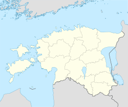
Fläche 1,9 km²
Höchste Erhebung 2,1 m
Lage von Suurlaid
Lage von Suurlaid

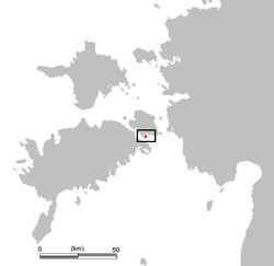
Suurlaid ist eine estnische Ostsee-Insel.

Suurlaid liegt etwa 500 vor der Südküste der estnischen Insel Muhu. Das nächstgelegene Dorf an der Küste von Muhu ist Pädaste.

Die Insel hat einen Gesamtfläche von 1,9 km². Sie ist sehr flach. Die höchste Stelle liegt nur 2,1 m über dem Meeresspiegel.

Um die Insel herum wurden reichhaltige Fischbestände nachgewiesen. Auf der Insel selbst wird ein Bauernhof bewirtschaftet.


Wikimedia Foundation.

Игры ⚽ Нужно решить контрольную?

Schlagen Sie auch in anderen Wörterbüchern nach:

  • Suurlaid — (English: Big Islet ) is an small island in the Baltic Sea belonging to the country of Estonia. Its coordinates are coord|58|31|42|N|23|15|39|E| [ [http://wikimapia.org/6173379/et/Suurlaid Wikimapia: Suurlaid] ] Suurlaid lies just off south coast …   Wikipedia

  • Muhu — (German: Mohn/Moon; in Estonian also called Muhumaa), is an island in the Baltic Sea. With an area of 198 km² it is the third largest island belonging to Estonia, after Saaremaa and Hiiumaa. Together with neighbouring smaller islands of… …   Wikipedia

  • Liste der Inseln Estlands — Die Liste der Inseln Estlands gibt einen Überblick über zahlreiche kleine und große Inseln. Vor der estnischen Ostseeküste liegen 1520 Inseln, von denen aber nur 19 bewohnt sind.Die größte ist Saaremaa. Die größten Inseln Estlands… …   Deutsch Wikipedia

  • Muhumaa — Lage von Muhu Karte der Insel Muhu Muhu (dt. Moon oder Mohn) ist mit 198 km² die drittgrößte Insel Estlands. Die in der nördlichen Osts …   Deutsch Wikipedia

  • Saaremaa — This article is about the island. For the village in Võru County, see Saaremaa, Võru County. Saaremaa …   Wikipedia

  • Hiiumaa — Tahkuna peninsula is the most northern part of Hiiumaa Geography …   Wikipedia

  • List of islands of Estonia — This is a list of islands of Estonia. There are 1521 islands. This is not a complete list. CompactTOC10|sections= A B C D E F G H I J K L M N O P Q R S Š Z Ž T U V W Õ Ä Ö Ü X YAAbruka Adralaid Aegna (Wulf) Ahelaid Aherahu (Atla) Aherahu Ahessäär …   Wikipedia

  • Vormsi — Estonia s fourth largest island, Vormsi (German: Worms, Swedish: Ormsö), is located between Hiiumaa and the mainland with a total area of 93 square kilometers. It is part of a rural municipality Vormsi Parish. From mainland, Vormsi is separated… …   Wikipedia

  • Naissaar — from the air Viimsi parish Naissaar …   Wikipedia

  • Osmussaar — Limestone cliff on the east coast of Osmussaar Geography Location …   Wikipedia

Share the article and excerpts

Direct link
Do a right-click on the link above
and select “Copy Link”