- Surallah
-
Municipality of Surallah Lage von Surallah in der Provinz South Cotabato 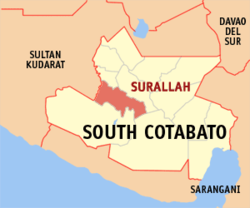
Basisdaten Bezirk: SOCCSKSARGEN Provinz: South Cotabato Barangays: 17 Distrikt: 2. Distrikt von South Cotabato PSGC: 126313000 Einkommensklasse: 1. Einkommensklasse Haushalte: 13.364 Zensus 1. Mai 2000Einwohnerzahl: 71.513 Zensus 1. August 2007Koordinaten: 6° 22′ N, 124° 44′ O6.3666666666667124.73333333333Koordinaten: 6° 22′ N, 124° 44′ O Bürgermeister: Romulo Octaviano Solivio Sr. Offizielle Webpräsenz: www.surallahscot.gov.ph Geographische Lage auf den Philippinen 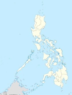

Surallah Surallah ist eine philippinische Stadtgemeinde in der Provinz South Cotabato. Nach dem Zensus vom 1. Mai 2000 hat sie 66.208 Einwohner in 13.364 Haushalten.
Baranggays
Surallah ist politisch in 17 Baranggays unterteilt.´
- Buenavista
- Centrala
- Colongulo
- Dajay
- Duengas
- Canahay (Godwino)
- Lambontong
- Lamian
- Lamsugod
- Libertad (Pob.)
- Little Baguio
- Moloy
- Naci (Doce)
- Talahik
- Tubiala
- Upper Sepaka
- Veterans
Städte und Stadtgemeinden in der Provinz South CotabatoStädte: Koronadal City | General Santos City
Stadtgemeinden: Banga | Lake Sebu | Norala | Polomolok | Santo Niño | Surallah | T'Boli | Tampakan | Tantangan | Tupi
Wikimedia Foundation.
Schlagen Sie auch in anderen Wörterbüchern nach:
Surallah — Original name in latin Surallah Name in other language AAV, Surallah State code PH Continent/City Asia/Manila longitude 6.37527 latitude 124.74521 altitude 195 Population 31089 Date 2013 02 19 … Cities with a population over 1000 database
Surallah, South Cotabato — Surallah is a 1st class municipality in the province of South Cotabato, Philippines. According to the 2000 census, it has a population of 66,208 people in 13,364 households.BarangaysSurallah is politically subdivided into 17 barangays. *… … Wikipedia
South Cotabato — Infobox Philippine province name = South Cotabato sealfile = Ph seal south cotabato.png region = SOCCSKSARGEN (Region XII) capital = Koronadal City founded = pop2000 = 1,102,550 pop2000rank = 21st largest popden2000 = 246 popden2000rank = 30th… … Wikipedia
Koronadal City — Infobox Philippine city infoboxtitle = City of Koronadal sealfile = koronadal logo.jpg locatormapfile = Ph locator south cotabato koronadal.png caption = Map of South Cotabato showing the location of Koronadal City. region = SOCCSKSARGEN (Region… … Wikipedia
Allah Valley Airport — Infobox Airport name = Allah Valley Airport nativename = nativename a = nativename r = image width = caption = IATA = AAV ICAO = RPMA type = public owner = operator = Air Transportation Office city served = Surallah, South Cotabato location =… … Wikipedia
PH-SCO — Lage der Provinz South Cotabato South Cotabato ist eine Provinz der Philippinen. Sie befindet sich im Süden der Hauptlandmasse der Insel Mindanao. Politisch gehört die Provinz zu dem Bezirk Nummer XII, auch genannt SOCCSKSARGEN. Die Hauptstadt… … Deutsch Wikipedia
Koronadal — Ciudad sang Koronadal 1st Class City City of Koronadal … Wikipedia
List of hospitals in the Philippines — This is a partial list of hospitals in the Philippines.LuzonILOCOS NORTE*Mariano Marcos Memorial Hospital Batac CityBaguio City*Baguio General Hospital *Saint Louis University Hospital of the Secret Heart *BCU Sto. Nino Jesus Hospital foundation… … Wikipedia
Lake Sebu, South Cotabato — Lake Sebu is a 2nd class municipality in the province of South Cotabato, Philippines. According to the 2000 census, it has a population of 54,142 people in 11,158 households.BarangaysLake Sebu is politically subdivided into 19 barangays. *… … Wikipedia
Fasciolosis — Classification and external resources ICD 10 B66.3 ICD 9 121.3 … Wikipedia
Surallah


18+
© Academic, 2000-2024
- Kontaktieren Sie uns: Unterstützung, Werbung
Wörterbücher Export, schritte mit PHP, Joomla, Drupal, WordPress, MODx.