Stromness Bay

Stromness Bay
Stromness Bay mit (links nach rechts) Husvik, Stromness und Leith Harbour (NASA-Bild).
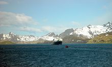
Stromness Bay im November 2002

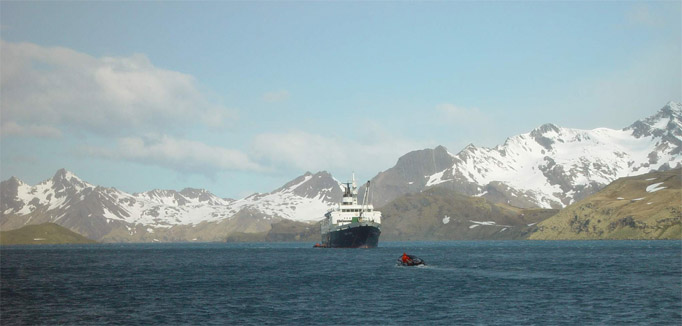
Stromness Bay ist der Name einer Bucht, die 4,8 Kilometer weit ist und deren Einfahrt sich zwischen Cape Saunders und dem Busen Point an der Nordküste Südgeorgiens befindet. Die erste Sichtung fand vermutlich 1775 durch James Cook statt; benannt wurde sie um 1912, vermutlich durch norwegische Walfänger, die ihre Häfen benutzen.

Während des Zweiten Weltkriegs wurde am Eingang zur Stromness Bay von der Royal Navy eine Geschützstellung eingerichtet, um den Zugang zu Leith Harbour zu schützen. Das Geschütz wurde mit norwegischen Walfängern besetzt, die zuvor zu diesem Zweck ausgebildet worden waren.

Die drei Walfangstationen Husvik, Grytviken und Leith Harbour waren durch einen unebenen Pfad am Ufer der Bucht verbunden. Während der Walfangära wurde er von Walfängern aus Grytviken und Husvik benutzt, um das Kino von Leith Harbour zu erreichen, das das einzige auf der ganzen Insel war.

In der Stromness Bay liegt die unbewohnte Insel Grass Island .

Siehe auch

Cumberland Bay, King Haakon Bay, Possession Bay, Royal Bay

-54.15-36.633333333333

Wikimedia Foundation.

Игры ⚽ Нужна курсовая?

Schlagen Sie auch in anderen Wörterbüchern nach:

  • Stromness Bay — (coord|54|9|S|36|38|W|) is a bay 3 miles (4.8 km) wide, entered between Cape Saunders and Busen Point on the north coast of South Georgia. Stromness Bay, like Leith Harbour takes its name from a location in Scotland, Stromness, on the Orkney… …   Wikipedia

  • Stromness (Südgeorgien) — Stromness Bay mit (links nach rechts) Husvik, Stromness und Leith Harbour (NASA Bild) …   Deutsch Wikipedia

  • Stromness, South Georgia — Stromness (coord|54|9|S|36|41|W|) is a former whaling station on the northern coast of South Georgia Island in the South Atlantic. Its historical significance is that it represents the destination of Ernest Shackleton s epic rescue journey in… …   Wikipedia

  • Stromness (Georgie du Sud) — Stromness (Géorgie du Sud) Pour les articles homonymes, voir Stromness. Stromness Bay avec (gauche à droite) Husvik, Stromness, et Leith Harbour (Image de la NASA) …   Wikipédia en Français

  • Stromness (géorgie du sud) — Pour les articles homonymes, voir Stromness. Stromness Bay avec (gauche à droite) Husvik, Stromness, et Leith Harbour (Image de la NASA) …   Wikipédia en Français

  • Stromness — bezieht sich auf folgende Orte: Stromness (Orkney), den Ort auf Mainland, Orkneyinseln Stromness (Südgeorgien), die ehemalige Walfangstation auf Südgeorgien Stromness Bay, die Bucht in Südgeorgien Stromness bezeichnet den Roman Stromness… …   Deutsch Wikipedia

  • Stromness (Géorgie du Sud) — 54°9′S 36°41′W / 54.15, 36.683 …   Wikipédia en Français

  • Stromness (Orkney) — Stromness Koordinaten 58° 58′ N, 3° …   Deutsch Wikipedia

  • Stromness —    STROMNESS, a sea port town, burgh of barony, and parish, in the county of Orkney, 14 miles (W. by S.) from Kirkwall; containing 2785 inhabitants, of whom 2057 are in the town. This place derives its name from a point of land at its southern… …   A Topographical dictionary of Scotland

  • Stromness — infobox UK place country = Scotland official name= Stromness population = 2200 (approx.) os grid reference= HY2509 latitude= 58.96 longitude= 3.3 unitary scotland= Orkney Islands lieutenancy scotland= Orkney Islands constituency westminster=… …   Wikipedia

Share the article and excerpts

Direct link
Do a right-click on the link above
and select “Copy Link”