- Stark County (Ohio)
-

Verwaltung US-Bundesstaat: Ohio Verwaltungssitz: Canton Adresse des
Verwaltungssitzes:County Administration Building
110 Central Plaza South
Canton, OH 44702-1410Gründung: 13. Februar 1808 Gebildet aus: Columbiana County Vorwahl: 001 330 Demographie Einwohner: 375.586 (2010) Bevölkerungsdichte: 251,6 Einwohner/km² Geographie Fläche gesamt: 1.505 km² Wasserfläche: 12 km² Karte 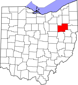
Website: www.co.stark.oh.us Das Stark County[2] ist ein County im US-amerikanischen Bundesstaat Ohio. Bei der Volkszählung im Jahr 2010 hatte das County 375.586 Einwohner und eine Bevölkerungsdichte von 251,6 Einwohnern pro Quadratkilometer. Der Verwaltungssitz (County Seat) ist Canton.
Das Stark County ist Bestandteil der Metropolregion Canton–Massillon.
Inhaltsverzeichnis
Geografie
Das Stark County liegt im Nordosten von Ohio, ist im Osten etwa 65 km von der Grenze zu Pennsylvania entfernt und hat eine Fläche von 1.505 Quadratkilometern, wovon 12 Quadratkilometer Wasserfläche sind. Es grenzt an folgende Countys:
Summit County Portage County Mahoning County Wayne County 
Columbiana County Holmes County Tuscarawas County Carroll County Geschichte
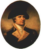
 J. Stark
Das Stark County wurde am 13. Februar 1808 aus Teilen des Columbiana County gebildet. Benannt wurde es nach John Stark (1728-1822), einem General der Kontinentalarmee im Amerikanischen Unabhängigkeitskrieg.
Demografische Daten
Historische Einwohnerzahlen Census Einwohner ± in % 1810 2734 — 1820 12.406 400 % 1830 26.588 100 % 1840 34.603 30 % 1850 39.878 20 % 1860 42.978 8 % 1870 52.508 20 % 1880 64.031 20 % 1890 84.170 30 % 1900 94.747 10 % 1910 122.987 30 % 1920 177.218 40 % 1930 221.784 30 % 1940 234.887 6 % 1950 283.194 20 % 1960 340.345 20 % 1970 372.210 9 % 1980 378.823 2 % 1990 367.585 -3 % 2000 378.098 3 % 2010 375.586 -0,7 % Vor 1900[3] 1900–1990[4] 2000[5] 2010[6] Nach der Volkszählung im Jahr 2010 lebten im Stark County 375.586 Menschen in 150.562 Haushalten. Die Bevölkerungsdichte betrug 251,6 Einwohner pro Quadratkilometer.
Ethnisch betrachtet setzte sich die Bevölkerung zusammen aus 88,7 Prozent Weißen, 7,6 Prozent Afroamerikanern, 0,3 Prozent amerikanischen Ureinwohnern, 0,7 Prozent Asiaten sowie aus anderen ethnischen Gruppen; 2,2 Prozent stammten von zwei oder mehr Ethnien ab. Unabhängig von der ethnischen Zugehörigkeit waren 1,6 Prozent der Bevölkerung spanischer oder lateinamerikanischer Abstammung.
In den 150.562 Haushalten lebten statistisch je 2,46 Personen.
22,9 Prozent der Bevölkerung waren unter 18 Jahre alt, 60,9 Prozent waren zwischen 18 und 64 und 16,2 Prozent waren 65 Jahre oder älter. 51,6 Prozent der Bevölkerung war weiblich.
Das jährliche Durchschnittseinkommen eines Haushalts lag bei 44.363 USD. Das Pro - Kopf - Einkommen betrug 23.660 USD. 14,8 Prozent der Einwohner lebten unterhalb der Armutsgrenze.[7]
Städte und Gemeinden
 Karte des Stark Countys
- Beach City
- Brewster
- East Canton
- East Sparta
- Hartville
- Hills and Dales
- Limaville
- Magnolia
- Minerva
- Meyers Lake
- Navarre
- Waynesburg
- Wilmot
Census-designated places (CDP)
- Greentown
- Perry Heights
- Uniontown
- Avondale
- Cairo
- Marchand
- Maximo
- Middlebranch
- New Franklin
- North Industry
- North Lawrence
- Paris
- Richville
- Robertsville
- Waco
Townships
- Bethlehem
- Canton
- Jackson
- Lake
- Lawrence
- Lexington
- Marlboro
- Nimishillen
- Osnaburg
- Paris
- Perry
- Pike
- Plain
- Sandy
- Sugar Creek
- Tuscarawas
- Washington
Einzelnachweise
- ↑ Auszug aus dem National Register of Historic Places Abgerufen am 13. März 2011
- ↑ Stark County im Geographic Names Information System des United States Geological Survey Abgerufen am 22. Februar 2011
- ↑ U.S. Census Bureau _ Census of Population and Housing Abgerufen am 17. Februar 2011
- ↑ Auszug aus Census.gov Abgerufen am 21. Februar 2011
- ↑ Auszug aus factfinder.census.gov Abgerufen am 21. Februar 2011
- ↑ United States Census 2010 Abgerufen am 1. November 2011
- ↑ U.S. Census Buero, State & County QuickFacts - Stark County Abgerufen am 1. November 2011
Weblinks
-
 Commons: Stark County, Ohio – Sammlung von Bildern, Videos und Audiodateien
 - Offizielle Webseite
- U.S. Census Buero, State & County QuickFacts - Stark County
- Yahoo Bildersuche - Stark County
- www.city-data.com - Stark County

Liste der Countys in Ohio
Adams | Allen | Ashland | Ashtabula | Athens | Auglaize | Belmont | Brown | Butler | Carroll | Champaign | Clark | Clermont | Clinton | Columbiana | Coshocton | Crawford | Cuyahoga | Darke | Defiance | Delaware | Erie | Fairfield | Fayette | Franklin | Fulton | Gallia | Geauga | Greene | Guernsey | Hamilton | Hancock | Hardin | Harrison | Henry | Highland | Hocking | Holmes | Huron | Jackson | Jefferson | Knox | Lake | Lawrence | Licking | Logan | Lorain | Lucas | Madison | Mahoning | Marion | Medina | Meigs | Mercer | Miami | Monroe | Montgomery | Morgan | Morrow | Muskingum | Noble | Ottawa | Paulding | Perry | Pickaway | Pike | Portage | Preble | Putnam | Richland | Ross | Sandusky | Scioto | Seneca | Shelby | Stark | Summit | Trumbull | Tuscarawas | Union | Van Wert | Vinton | Warren | Washington | Wayne | Williams | Wood | Wyandot
Wikimedia Foundation.
Schlagen Sie auch in anderen Wörterbüchern nach:
Stark County, Ohio — Infobox U.S. County county = Stark County state = Ohio seallink = founded date = February 13 founded year = 1808cite web|url = http://www.odod.state.oh.us/research/FILES/S0/Stark.pdf |title = Ohio County Profiles: Stark County |accessdate = 2007… … Wikipedia
Stark County Area Vocational School District, Stark County, Ohio — Stark County Area Vocational School District is a school district located in Stark County, Ohio, United States. It operates the R.D. Drage Career Center.External links* [http://www.drage.stark.k12.oh.us/ Official Site] … Wikipedia
National Register of Historic Places listings in Stark County, Ohio — Location of Stark County in Ohio This is a list of the National Register of Historic Places listings in Stark County, Ohio. This is intended to be a complete list of the properties and districts on the National Register of Historic Places in… … Wikipedia
Marlboro Township, Stark County, Ohio — Township Municipalities and townships of Stark Cou … Wikipedia
Osnaburg Township, Stark County, Ohio — Osnaburg Township, Ohio Township Municipalities and townships of Stark County … Wikipedia
Nimishillen Township, Stark County, Ohio — Nimishillen Township, Ohio Township Municipalities and townships of Stark County … Wikipedia
Plain Township, Stark County, Ohio — Infobox Settlement official name = Plain Township, Stark County, Ohio settlement type = Township nickname = motto = imagesize = image caption = image mapsize = 250px map caption = Municipalities and townships of Stark County. mapsize1 = map… … Wikipedia
Lake Township, Stark County, Ohio — Infobox Settlement official name = Lake Township, Stark County, Ohio settlement type = Township nickname = motto = imagesize = image caption = image mapsize = 250px map caption = Municipalities and townships of Stark County. mapsize1 = map… … Wikipedia
Sugar Creek Township, Stark County, Ohio — Infobox Settlement official name = Sugar Creek Township, Stark County, Ohio settlement type = Township nickname = motto = imagesize = image caption = image mapsize = 250px map caption = Municipalities and townships of Stark County. mapsize1 = map … Wikipedia
Canton Township, Stark County, Ohio — Infobox Settlement official name = Canton Township, Ohio settlement type = Township nickname = motto = imagesize = image caption = image mapsize = 250x200px map caption = Municipalities and townships of Stark County. mapsize1 = map caption1 =… … Wikipedia
Stark County (Ohio)


18+
© Academic, 2000-2024
- Kontaktieren Sie uns: Unterstützung, Werbung
Wörterbücher Export, schritte mit PHP, Joomla, Drupal, WordPress, MODx.