- South Kensington
-
Royal Borough of Kensington and Chelsea 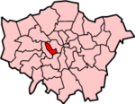
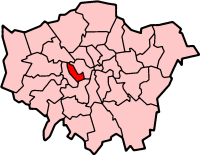
Lage in Greater LondonStatus London Borough, Royal Borough Region Greater London Verwaltungssitz Kensington Fläche 12,13 km² (353.) Einwohner (2007) 178.600 (83.) ONS-Code 00AW Website www.rbkc.gov.uk Der Royal Borough of Kensington and Chelsea [ˈkɛnzɪŋtən ən ˈtʃɛlsi] ist ein Stadtbezirk von London und bildet den westlichen Rand der Innenstadt. Er wurde 1965 bei der Gründung von Greater London aus den Bezirken Kensington und Chelsea der ehemaligen County of London gebildet. Der Zusatz „Royal Borough“ (königliche Gemeinde) wurde verliehen, weil der Stadtteil Kensington einst königlicher Privatbesitz war und nicht als Lehen vergeben wurde.
Der Bezirk ist die am dichtesten besiedelte Gebietskörperschaft in Großbritannien. Auf einem Quadratkilometer leben hier durchschnittlich 13.608 Menschen. Die Bevölkerung setzt sich zusammen aus 78,6 % Weißen, 4,9 % Südasiaten, 7,0 % Schwarzen und 1,6 % Chinesen.
Stamford Bridge, das Fußballstadion des FC Chelsea liegt entgegen der vorherrschenden Meinung im benachbarten Stadtteil Fulham.
Stadtteile
- Brompton
- Chelsea
- Earl's Court
- Holland Park
- Kensington
- North Kensington
- Notting Hill
- South Kensington
- West Brompton
Sehenswürdigkeiten
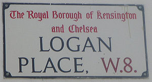 Straßenschild in Kensington
- Hyde Park - einst ein königliches Jagdrevier
- Kensington Gardens
- das Museumsviertel South Kensington mit dem Natural History Museum, dem Science Museum und dem Victoria and Albert Museum
- Royal Albert Hall - Konzerthalle
- Sloane Street - luxuriöse Einkaufsmeile, die dort lebenden Menschen gelten als versnobt und werden Sloane Rangers genannt
- Imperial College - eine der renommiertesten Universitäten der Welt
- Royal College of Music
- Notting Hill - bekannt für den gleichnamigen Film und dem Notting Hill Carnival
- Antiquitätenmarkt in der Portobello Road
Weblinks
Stadtbezirke von LondonBarking and Dagenham | Barnet | Bexley | Brent | Bromley | Camden | City of London | City of Westminster | Croydon | Ealing | Enfield | Greenwich | Hackney | Hammersmith and Fulham | Haringey | Harrow | Havering | Hillingdon | Hounslow | Islington | Kensington and Chelsea | Kingston | Lambeth | Lewisham | Merton | Newham | Redbridge | Richmond | Southwark | Sutton | Tower Hamlets | Waltham Forest | Wandsworth
Sonstige Einteilung: Greater London | Inner London | Outer London | County of London

Wikimedia Foundation.