- South Derbyshire
-
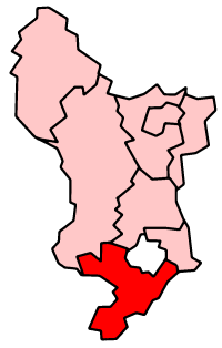
South Derbyshire District 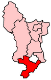
Lage in DerbyshireStatus District Region East Midlands Verw.grafschaft Derbyshire Verwaltungssitz Swadlincote Fläche 338,12 km² (144.) Einwohner 91.200 (55.) ONS-Code 17UK Website www.south-derbys.gov.uk South Derbyshire ist ein District in der Grafschaft Derbyshire in England. Verwaltungssitz ist die Stadt Swadlincote; weitere bedeutende Orte sind Aston-on-Trent und Melbourne.
Der Bezirk wurde am 1. April 1974 gebildet und entstand aus der Fusion des Urban District Swadlincote, des Rural District Repton und eines Teils des Rural District South East Derbyshire.
Amber Valley | Bolsover | Chesterfield | Derbyshire Dales | Erewash | High Peak | North East Derbyshire | South Derbyshire
Wikimedia Foundation.
Schlagen Sie auch in anderen Wörterbüchern nach:
South Derbyshire — Distrito del Reino Unido Ubicación en el condado de Derbyshire … Wikipedia Español
South Derbyshire — Infobox UK district name = South Derbyshire District status = District region = East Midlands admincounty = Derbyshire area = Ranked 144th 338.12 km² adminhq = Swadlincote onscode = 17UK population = Ranked English district rank|ONS=17UK English… … Wikipedia
South Derbyshire (UK Parliament constituency) — South Derbyshire County constituency for the House of Commons Boundary of South Derbyshire in Derbyshire … Wikipedia
South Derbyshire local elections — South Derbyshire Council is elected every four years.Political controlLabour 1973 1976No overall control 1976 1983Labour 1983 2007Conservative 2007 presentCouncil electionsSouth Derbyshire Council election, 1999South Derbyshire Council election,… … Wikipedia
South Derbyshire — ▪ district, England, United Kingdom district, administrative and historic county of Derbyshire, England. Undulating arable land is interspersed with meadowland in the valleys of the Rivers Derwent, Dove, and Trent, although the Trent valley … Universalium
Derbyshire Constabulary — Logo of the Derbyshire Constabulary. Agency overview … Wikipedia
Derbyshire Dales (UK Parliament constituency) — Derbyshire Dales County constituency for the House of Commons Boundary of Derbyshire Dales in Derbyshire for the 2010 general elect … Wikipedia
Derbyshire (European Parliament constituency) — Derbyshire European Parliament constituency European Parliament logo Created 1979 Dissolved 1994 MEP(s) 1 … Wikipedia
Derbyshire Miners' Association — Founded 1880 Date dissolved 1945 Merged into National Union of Mineworkers Country United Kingdom … Wikipedia
South East Derbyshire Rural District — South East Derbyshire was a rural district in Derbyshire, England from 1894 to 1974. It covered an area to the south east of Derby.It was formed as Shardlow rural district under the Local Government Act 1894, mainly from the Derbyshire part of… … Wikipedia
South Derbyshire
18+
© Academic, 2000-2024
- Kontaktieren Sie uns: Unterstützung, Werbung
Wörterbücher Export, schritte mit PHP, Joomla, Drupal, WordPress, MODx.