- Somerville (Massachusetts)
-
Somerville 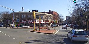
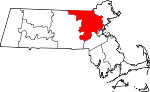
Davis Square, SomervilleLage in Massachusetts 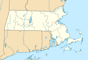

Somerville Basisdaten Gründung: 1630 Staat: Vereinigte Staaten Bundesstaat: Massachusetts County: Koordinaten: 42° 23′ N, 71° 6′ W42.3875-71.14Koordinaten: 42° 23′ N, 71° 6′ W Zeitzone: Eastern Standard Time (UTC−5) Einwohner: 77.478 (Stand: 2000) Bevölkerungsdichte: 7.309,2 Einwohner je km² Fläche: 10,9 km² (ca. 4 mi²)
davon 10,6 km² (ca. 4 mi²) LandHöhe: 4 m Postleitzahlen: 02143-02145 Vorwahl: +1 617, 857 FIPS: 25-62535 GNIS-ID: 0612815 Webpräsenz: www.somervillema.gov Bürgermeister: Joseph A. Curtatone Somerville ist eine Stadt im Middlesex County im US-Bundesstaat Massachusetts, nördlich von Boston. In Bezug auf den Census von 2000 hat die Stadt 77.478 Einwohner. Mit einer Fläche von nur knapp über 10 km² ist sie die am dichtesten besiedelte Gemeinde in Neuengland.
Gegründet wurde das damals noch überwiegend ländlich geprägte Somerville 1842 durch Loslösung von der Stadt Charlestown.Inhaltsverzeichnis
Geographie
Die Stadt hat eine Gesamtfläche von 10,9 km² (4,2 mi²). Hiervon sind 10,6 km² (4,2 mi²) Land- und 0,3 km² (0,1 mi²) Wasserfläche. Der Anteil von Wasser an der Gesamtfläche beträgt 2,61%.
In Somerville findet man eine Anzahl an Plätzen, die als Zentren von Geschäftstätigkeiten und Unterhaltung gelten, wie z.B. Davis Square, Union Square, Ball Square, Teele Square und Magoun Square.
Die von Bäumen umsäumte stillgelegte Eisenbahnstrecke führt durch das Herz von Davis Square und nennt sich Somerville Community Path. Die Stadt verfügt über einige Gruppen, wie z.B. der Freunde des Community Paths, die sich darum bemühen, den Minuteman Radweg/Linear Park von seinem Ende an der Cedar Street in Somerville entlang des Charles River-Radwegs bis hin nach Boston auszuweiten.
Hügel
Die sieben Hügel von Somerville heißen:
- Clarendon Hill
- Cobble Hill
- Ploughed Hill
- Prospect Hill
- Spring Hill
- Walnut Hill
- Winter Hill
Söhne und Töchter der Stadt
- Hal Clement, Science-Fiction-Schriftsteller
- Hal Connolly, Hammerwerfer
- Matthew Delaney, Schriftsteller
- Henry Franklin Gilbert, Komponist
- Nelson Goodman, Philosoph
- Ralph Hepburn, Motorrad- und Automobilrennfahrer
- Henry Kimball Hadley, Komponist und Dirigent
- Alan Hovhaness, Komponist armenisch-schottischer Abstammung
- Bobby Pickett, Sänger ("Monster Mash") und Schauspieler
- Charles Revson, Kosmetikproduzent und Gründer von Revlon
- Harry Nelson Pillsbury, Schachspieler
Weblinks
 Städte und Gemeinden im Middlesex County (Massachusetts)
Cities: Cambridge | Everett | Lowell | Malden | Marlborough | Medford | Melrose | Newton | Somerville | Waltham | Watertown | Woburn
Towns: Acton | Arlington | Ashby | Ashland | Ayer | Bedford | Belmont | Billerica | Boxborough | Burlington | Carlisle | Chelmsford | Concord | Dracut | Dunstable | Framingham | Groton | Holliston | Hopkinton | Hudson | Lexington | Lincoln | Littleton | Maynard | Natick | North Reading | Pepperell | Reading | Sherborn | Shirley | Stoneham | Stow | Sudbury | Tewksbury | Townsend | Tyngsborough | Wakefield | Wayland | Westford | Weston | Wilmington | Winchester
Villages: Auburndale | Chestnut Hill | Gleasondale | Newton Centre | Newton Highlands | Newton Lower Falls | Newton Upper Falls | Newtonville | Nonantum | North Billerica | North Chelmsford | Waban | West Newton
Wikimedia Foundation.
Schlagen Sie auch in anderen Wörterbüchern nach:
Somerville, Massachusetts — City Davis Square, Somerville … Wikipedia
Somerville (Massachusetts) — Somerville Ciudad de los Estados Unidos Vista de Somerville … Wikipedia Español
Somerville, Massachusetts — Somerville Davis Square, Somerville Lage in Massachusetts … Deutsch Wikipedia
Somerville (Massachusetts) — Pour les articles homonymes, voir Somerville. Somerville est une ville du Massachusetts, Comté de Middlesex, au nord de Boston. Selon le recensement de 2000, la population était de 77 478 habitants. Jumelages Tizn … Wikipédia en Français
National Register of Historic Places listings in Somerville, Massachusetts — Location of Somerville in Massachusetts This is a list of properties and historic districts in Somerville, Massachusetts that have been listed on the National Register of Historic Places … Wikipedia
Winter Hill, Somerville, Massachusetts — Winter Hill is a neighborhood in Somerville, Massachusetts. Located roughly north of Highland Avenue and west of the McGrath Highway, Winter Hill is home to a mix of restored homes and run down Triple Deckers, replete with china gnomes and… … Wikipedia
Spring Hill, Somerville, Massachusetts — Spring Hill is the name of a ridge in the central part of the city of Somerville, Massachusetts, and the neighborhood that sits atop it. It runs northwest to southeast, roughly bounded by Somerville Avenue, Elm Street, Willow Avenue, Highland… … Wikipedia
Round House (Somerville, Massachusetts) — The Round House is a cylindrical wood frame residential structure at 36 Atherton Street in the Spring Hill neighborhood of Somerville, Massachusetts, USA. It was built in 1856 by hardware manufacturer Enoch Robinson, and is considered an offshoot … Wikipedia
First Universalist Church (Somerville, Massachusetts) — Infobox nrhp | name =First Universalist Church nrhp type = caption = location= Somerville, Massachusetts lat degrees = 42 lat minutes = 23 lat seconds = 15 lat direction = N long degrees = 71 long minutes = 6 long seconds = 5 long direction = W… … Wikipedia
Central Library (Somerville, Massachusetts) — Infobox nrhp | name =Central Library nrhp type = caption = location= Somerville, Massachusetts lat degrees = 42 lat minutes = 23 lat seconds = 9 lat direction = N long degrees = 71 long minutes = 5 long seconds = 40 long direction = W locmapin =… … Wikipedia
Somerville (Massachusetts)


18+
© Academic, 2000-2024
- Kontaktieren Sie uns: Unterstützung, Werbung
Wörterbücher Export, schritte mit PHP, Joomla, Drupal, WordPress, MODx.