Shepherd’s Bush

Shepherd’s Bush
Shepherd’s Bush (Greater London)
Shepherd’s Bush
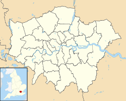
Shepherd’s Bush
Lage von Shepherd’s Bush in Greater London

Shepherd’s Bush (manchmal auch Shepherds Bush geschrieben) ist ein Stadtteil von London. Er gehört zum London Borough of Hammersmith and Fulham und liegt rund acht Kilometer westlich von Charing Cross. Im Norden grenzt der Stadtteil an Willesden und Harlesden, im Osten an Holland Park, im Süden an Hammersmith und im Westen an Acton und Chiswick.

Das Zentrum des Stadtteils ist der Shepherd’s Bush Green, ein rund 3,2 Hektar großer dreieckiger Park, der auf allen drei Seiten von Hauptstraßen umgeben ist. Auf seiner Westseite zweigen vier weitere Hauptstraßen ab, auf seiner Ostseite deren drei. Im Osten wird der Stadtteil durch die Eisenbahnlinie West London Line und einen Autobahnzubringer begrenzt. Drei U-Bahn-Stationen der London Underground erschließen Shepherd’s Bush: Die Station Shepherd’s Bush der Central Line an der Ostseite des Parks sowie die Stationen Shepherd’s Bush Market und Goldhawk Road westlich des Parks, wo die Circle Line und die Hammersmith & City Line verkehren; hinzu kommt der Bahnhof Shepherd’s Bush an der West London Line.

Shepherd’s Bush Green

Wirtschaftlich von überragender Bedeutung ist das Einkaufszentrum Westfield London. Im nordwestlichen Teil von Shepherd’s Bush befindet sich an der Loftus Road das Stadion des Fußballvereins Queens Park Rangers.

Weblinks

51.504-0.221

Wikimedia Foundation.

Игры ⚽ Поможем написать курсовую

Schlagen Sie auch in anderen Wörterbüchern nach:

  • Shepherd's Bush F.C. — Shepherd s Bush Full name Shepherd s Bush Football Club Nickname(s) The Bushmen Founded 1880 Dissolved 1915 Ground …   Wikipedia

  • Shepherd's Bush — Boutiques sur Uxbridge Road. Géographie Pays …   Wikipédia en Français

  • Shepherd's Bush — Shepherd’s Bush bezeichnet: einen Stadtteil des London Borough of Hammersmith and Fulham eine Station der Central Line der London Underground, siehe dazu Shepherd’s Bush (Central Line) eine Station der Hammersmith City Line der London Underground …   Deutsch Wikipedia

  • Shepherd's Bush — Shepherd’s Bush [Shepherds Bush] an area of west London, England, consisting mainly of houses and flats/apartments and a busy market and shopping centre …   Useful english dictionary

  • Shepherd's Bush — infobox UK place country = England map type = Greater London region= London population= official name= Shepherd s Bush latitude= 51.5042 longitude= 0.2207 london borough= Hammersmith and Fulham constituency westminster= Ealing, Acton and… …   Wikipedia

  • Shepherd's Bush stations — Shepherd s Bush is a name used for a number of current and former stations in the Shepherd s Bush area of west London.Current stationsLondon Underground stations* Shepherd s Bush on the Central LineLondon Overground stationShepherd s Bush railway …   Wikipedia

  • Shepherd's Bush (Central Line) — Shepherd s Bush (métro de Londres) Shepherd s Bush Localisation …   Wikipédia en Français

  • Shepherd's Bush (Central line) — Shepherd s Bush (métro de Londres) Shepherd s Bush Localisation …   Wikipédia en Français

  • Shepherd's Bush (metro de Londres) — Shepherd s Bush (métro de Londres) Shepherd s Bush Localisation …   Wikipédia en Français

  • Shepherd's bush (métro de londres) — Shepherd s Bush Localisation …   Wikipédia en Français

Share the article and excerpts

Direct link
Do a right-click on the link above
and select “Copy Link”