- Sevenoaks (District)
-
Sevenoaks District 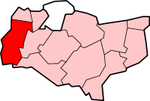
Lage in KentStatus District Region South East England Verw.grafschaft Kent Verwaltungssitz Sevenoaks Fläche 370,34 km² (128.) Einwohner 114.300 (186.) ONS-Code 29UK Website www.sevenoaks.gov.uk Sevenoaks ist ein District in der Grafschaft Kent in England. Verwaltungssitz ist Sevenoaks; weitere bedeutende Orte sind Ash-cum-Ridley, Brasted, Edenbridge, Farningham, Knockholt, Otford, Seal, Swanley und Westerham.
Der Bezirk wurde am 1. April 1974 gebildet und entstand aus der Fusion des Urban District Sevenoaks, des Rural District Sevenoaks und eines Teil des Rural District Dartford. Das Dorf Knockholt gehörte bis 1969 zum London Borough of Bromley und wurde dann dem Rural District Sevenoaks hinzugefügt.

Ashford | Canterbury | Dartford | Dover | Gravesham | Maidstone | Sevenoaks | Shepway | Swale | Thanet | Tonbridge and Malling | Tunbridge Wells
Wikimedia Foundation.
Schlagen Sie auch in anderen Wörterbüchern nach:
Sevenoaks (district) — Sevenoaks is a local government district covering the western most part of Kent in England. Its council is based in the town of Sevenoaks. It was formed on 1 April 1974, under the Local Government Act 1972, by a merger of the Sevenoaks Urban… … Wikipedia
Sevenoaks (district) — 51° 16′ 12″ N 0° 11′ 35″ E / 51.270, 0.193 … Wikipédia en Français
Sevenoaks — For the parliamentary constituency, see Sevenoaks (UK Parliament constituency). For the Community in Wesley Chapel Florida, see Seven Oaks Community. Coordinates: 51°16′41″N 0°11′15″E / … Wikipedia
Sevenoaks Weald — Infobox UK place official name= Sevenoaks Weald country= England region= South East England os grid reference= TL8504970050 latitude= 51.237892 longitude= 0.191258 post town= SEVENOAKS WEALD postcode area= TN postcode district= TN14 dial code=… … Wikipedia
Sevenoaks — Géolocalisation sur la carte : Royaume Uni … Wikipédia en Français
Sevenoaks — ▪ district, England, United Kingdom district occupying the westernmost portion of the administrative and historic county of Kent, England, southeast of London. It is a predominantly rural area with a rolling landscape. Much of the district… … Universalium
Sevenoaks (UK Parliament constituency) — UK constituency infobox Name = Sevenoaks Map1 = Sevenoaks Map2 = Kent Type = County Year = 1885 Entity = Kent County = Kent EP = South East England MP = Michael Fallon Party = ConservativeSevenoaks is a constituency represented in the House of… … Wikipedia
Sevenoaks Town F.C. — Football club infobox |clubname = Sevenoaks Town| pattern la1= black stripes|pattern b1= blackstripes|pattern ra1= black stripes leftarm1=0055A3|body1=0055A3|rightarm1=0055A3|shorts1=000000|socks1=000000| pattern la2=|pattern b2= unknown|pattern… … Wikipedia
Dartford Rural District — Dartford Geography 1911 area 37,997 acres (153.77 km2) 1931 area 33,400 acres (135 km2) 1961 area 34,037 acres (137.74 km2) HQ … Wikipedia
Crouch, Sevenoaks — Crouch (as in Peter Crouch) is a hamlet in the Sevenoaks District, in the English county of Kent. Contents 1 Location 2 Transport 3 References Location It is near the large town of Seveno … Wikipedia
Sevenoaks (District)

18+
© Academic, 2000-2024
- Kontaktieren Sie uns: Unterstützung, Werbung
Wörterbücher Export, schritte mit PHP, Joomla, Drupal, WordPress, MODx.