- Semisopochnoi Island
-
Semisopochnoi Island Südlicher Teil von Semisopochnoi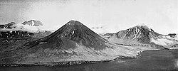
Gewässer Pazifischer Ozean Inselgruppe Rat Islands Geographische Lage 51° 57′ N, 179° 36′ O51.947222222222179.606944444441221Koordinaten: 51° 57′ N, 179° 36′ O 

Länge 17 km Breite 14 km Fläche 221,7 Höchste Erhebung Anvil Peak
1.221 mEinwohner (unbewohnt) Karte der West-Aleuten/ 15 - Semisopochnoi Island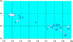
Semisopochnoi Island („Unyax“ auf Aleutisch) ist eine 21,67 km² große Insel der Rat Islands, einer Inselgruppe der Aleuten, die zwischen Nordamerika und Asien am Südrand des nordpazifischen Beringmeers liegt. Die von Vitus Bering im Jahr 1741 entdeckte Insel ist - als Teil des Pazifischen Feuerrings - vulkanischen Ursprungs, sie blieb bis heute unbewohnt und bietet für viele Seevögel ideale Brutbedingungen. Der Name „Semisopochnoi “ stammt aus dem Russischen und bedeutet „hat sieben Hügel“. Der aktivste Vulkan ist der Mount Cerberus mit 774 m Höhe, die Sugarloaf Peak im Süden der Insel ist 855 m hoch. Ihre aleutischen Namen lauten Unyax, bzw. Hawadax.
Inseln der Rat IslandsAmchitka | Bird Rock | Davidof | Khvostof | Kiska | Little Kiska | Little Sitkin | Lopy | Pyramid | Rat | Segula | Semisopochnoi | Tanadak
Wikimedia Foundation.
Schlagen Sie auch in anderen Wörterbüchern nach:
Semisopochnoi Island — ( ru. Семисопочныйndash having seven hills ; Aleut: Unyax [Bergsland, K Aleut Dictionary Fairbanks: Alaska Native Language Center, 1994] ) is part of the Rat Islands group in the western Aleutian Islands. The island is uninhabited and provides an … Wikipedia
Semisopochnoi — Vorlage:Infobox Insel/Wartung/Höhe fehlt Semisopochnoi Island Südlicher Teil von Semisopochnoi Gewässer Pazifischer Ozean Inselgruppe … Deutsch Wikipedia
Isla Semisopochnoi — La isla Semisopochnoi es una isla perteneciente al archipiélago de las islas Rata, en el grupo de las Islas Aleutianas. La isla se encuentra deshabitada y provee de una importante área de nidificación de aves marinas. La isla es de origen… … Wikipedia Español
Amchitka Island — Die Standorte der drei Kernwaffentests Bild aus Film über den Test Long Shot Amchitka ist eine vulkanische, tektonisch instabile Ins … Deutsch Wikipedia
Attu Island — Infobox Islands name = Attu image caption = Attu Island image size = 250px locator map custom = no native name = Atan native name link = Aleut language nickname = location = coordinates = coord|52|54|8.92|N|172|54|33.84|E|display=inline… … Wikipedia
Nunivak Island — Nunivak Maskette – Nunivak … Wikipedia
Medny Island — Map showing position of Commander Islands to the east of Kamchatka. The smaller island in the east is Medny and the larger island is Bering Island. Medny Island (also spelled Mednyy, Russian: остров Медный, sometimes called Copper Island in… … Wikipedia
Nelson Island (Alaska) — Nelson Native name: Qaluyaaq … Wikipedia
Unalaska Island — Unalaska Native name: Nawan Alaxsxa[1] Map of the island … Wikipedia
Chagulak Island — Location in Alaska … Wikipedia
Semisopochnoi Island


18+
© Academic, 2000-2024
- Kontaktieren Sie uns: Unterstützung, Werbung
Wörterbücher Export, schritte mit PHP, Joomla, Drupal, WordPress, MODx.