Rydal Water

Rydal Water
Rydal Water
Rydal Water vom Nab Scar aus gesehen
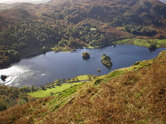
Zuflüsse River Rothay
Abfluss River Rothay
Orte am Ufer Rydal
Orte in der Nähe Ambleside, Grasmere
Daten
Koordinaten 54° 26′ 49″ N, 2° 59′ 47″ W54.44694-2.99639Koordinaten: 54° 26′ 49″ N, 2° 59′ 47″ W
Rydal Water (England)
Rydal Water
Länge 1,1 kmf6
Breite 370 mf7
Maximale Tiefe 16 mf10

Rydal Water ist einer der kleineren Seen im nordenglischen Nationalpark Lake District. Bei einer maximalen Tiefe von 16 m ist er 1,1 km lang und 370 m breit.

Der See liegt in der Nähe des Dörfchens Rydal zwischen den beiden Ortschaften Ambleside und Grasmere im Rothay Valley. Er wird vom River Rothay in Nord-Süd-Richtung durchflossen, der bei Ambleside in den Lake Windermere mündet.

In dem Ort lebte nach seinem Umzug von Dove Cottage nach Rydal Mount der Dichter William Wordsworth.

Ein weiterer bekannter Landsitz am Ufer des Rydal Water ist Nab Cottage, in dem die Schriftsteller Thomas de Quincey und Hartley Coleridge lebten.

Weblinks


Wikimedia Foundation.

Игры ⚽ Поможем написать курсовую

Schlagen Sie auch in anderen Wörterbüchern nach:

  • Rydal Water — Infobox lake lake name = Rydal Water image lake = Cumbria 2007 035.jpg caption lake = image bathymetry = caption bathymetry = location = Lake District, Cumbria coords = coord|54|26|49|N|2|59|47|W|region:GB type:waterbody scale:10000|display=title …   Wikipedia

  • Rydal Mount — is a house near Ambleside in the Lake District. It is best known as the home of William Wordsworth from 1813 to his death in 1850. Wordsworth was born in Cockermouth in Cumberland in 1770, and knew the Lake District well from his childhood. He… …   Wikipedia

  • Rydal Hall — is an early 19th century Grade II listed historic house on the outskirts of the village of Rydal, Cumbria in the Lake District, England. It is opposite Rydal Mount, home of the poet William Wordsworth. It used to be owned by the Le Fleming family …   Wikipedia

  • Rydal — (spr. raidël), Dorf in der engl. Grafschaft Westmorland, 2 km nordwestlich von Ambleside, am Ostende von R. Water, einem kleinen See, mit (1901) 458 Einw.; dabei R. Hall mit Park und 2 Wasserfällen, und R. Mount, von 1817–50 Wohnsitz des Dichters …   Meyers Großes Konversations-Lexikon

  • Coniston Water — View from Holme Fell, 1.5 miles (2.4 km) north Location Lake District, Cumbria Coordinates …   Wikipedia

  • Crummock Water — from Rannerdale Knotts …   Wikipedia

  • Cumbrian Mountains — Der Lake District (dt. Seebezirk, gleichbedeutend mit den Cumbrian Mountains), bekannt für seine eindrucksvolle Seen und Berglandschaft, ist einer von vierzehn Nationalparks des Vereinigten Königreichs. Er liegt vollständig in der Grafschaft… …   Deutsch Wikipedia

  • River Rothay — Rothay Trittsteine im Rothay bei RydalVorlage:Infobox Fluss/KARTE fehlt …   Deutsch Wikipedia

  • Loughrigg Fell — Infobox Mountain Name = Loughrigg Fell Photo = Loughrigg.jpg Caption = Elevation = 335 m (1,099 ft) Location = Cumbria, ENG Range = Lake District, Central Fells Prominence = c. 172 m Parent peak = High Raise Coordinates = Topographic OS… …   Wikipedia

  • Nab Scar — from Rydal Water with rainbow Nab Scar …   Wikipedia

Share the article and excerpts

Direct link
Do a right-click on the link above
and select “Copy Link”