Roding Valley (London Underground)
- Roding Valley (London Underground)
-
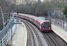
Ein Zug des Typs 1992 Tube Stock fährt in die Station ein
Roding Valley ist eine oberirdische Station der London Underground im Stadtbezirk London Borough of Redbridge. Sie liegt in der Travelcard-Tarifzone 4 am Buckhurst Way, unmittelbar an der Außengrenze von Greater London. Im Jahr 2009 frequentierten 0,209 Millionen Fahrgäste diese von der Central Line bediente Station, was sie zur am wenigsten genutzten Station des gesamten Netzwerkes macht.[1]
Ursprünglich war Roding Valley ein Haltepunkt an der Vorortseisenbahnlinie, die von Ilford über Hainault nach Woodford führte. Die Eröffnung erfolgte am 3. Februar 1936, der Name stammt vom Fluss Roding, der in der Nähe vorbeifließt. Der letzte von Dampflokomotiven gezogene Zug der London and North Eastern Railway verkehrte am 29. November 1947. Der U-Bahn-Betrieb begann knapp ein Jahr später nach der Elektrifizierung der Strecke, am 21. November 1948. Im darauf folgenden Jahr wurde das aus Holz bestehende Stationsgebäude durch einen dauerhafteren Neubau ersetzt.
Roding Valley gehört seit dem 5. Februar 2006 zu den ersten Stationen der London Underground, die nicht mehr mit Personal besetzt sind und über keinen Fahrkartenschalter verfügen. Gründe sind einerseits die geringe Nutzung, andererseits die zunehmende Verbreitung der Oyster Card, wodurch weniger Verkaufspersonal erforderlich ist. Bis zum 19. Oktober 2006 war bereits um 20:00 Uhr Betriebsschluss, seither um Mitternacht.
Einzelnachweise
- ↑ London Underground performance update
Weblinks
51.6169444444440.043888888888887
Kategorien:
- Station der London Underground
- Verkehr (London Borough of Redbridge)
Wikimedia Foundation.
Schlagen Sie auch in anderen Wörterbüchern nach:
Roding Valley tube station — Roding Valley is a London Underground station situated directly on the border between the Epping Forest district of Essex and the London Borough of Redbridge. The station is between Chigwell and Woodford stations. It is located in Station Way and … Wikipedia
List of London Underground stations — This is a list of London Underground stations. It includes all stations currently open on the London Underground and Docklands Light Railway, as well as Shepherd s Bush (Central Line) which will reopen in October 2008. The London Underground and… … Wikipedia
Liste der Stationen der London Underground — Dies ist die Liste der Stationen der London Underground, der U Bahn der britischen Hauptstadt London. Enthalten sind alle Stationen, die zurzeit in Betrieb sind oder sich im Bau befinden, ebenso Stationen, die vorübergehend wegen Bauarbeiten… … Deutsch Wikipedia
Chigwell (London Underground) — Stationsgebäude Bahnsteige in Richtung Westen gesehen … Deutsch Wikipedia
Woodford (London Underground) — Stationsgebäude Bahnsteig … Deutsch Wikipedia
London — /lun deuhn/, n. 1. Jack, 1876 1916, U.S. short story writer and novelist. 2. a metropolis in SE England, on the Thames: capital of the United Kingdom. 3. City of, an old city in the central part of the former county of London: the ancient nucleus … Universalium
London Crossrail — Maidenhead/Heathrow – Abbey Wood/Shenfield Logo Crossrail Spurweite: 1435 mm (Normalspur) Stromsystem: 25 kV 50 Hz Zweigleisigkeit … Deutsch Wikipedia
List of places in London — This is a partial list of places in London, England. See List of places in England for lists of settlements in other counties.London boroughsLondon is divided into thirty two London boroughs:† = Outer London for statistics | * = Inner London for… … Wikipedia
Geography of London — London is the largest urban area and capital city of the United Kingdom. Greater London covers an area of 609 square miles (1,579 square km). London is a port on the Thames (see main article Port of London ), a navigable river. The river has had… … Wikipedia
Fairlop Loop — The Fairlop Loop was a 6.5 mile (10 km) [ [http://www.cravensheritagetrains.co.uk/history.htm Cravens Heritage Trains History] ] branch line of the Great Eastern Railway (GER). It was opened to passenger traffic on 1 May 1903 (though it had… … Wikipedia
 Stationsgebäude
 Commons: Roding Valley (London Underground) – Sammlung von Bildern, Videos und Audiodateien

