- Rabodanges
-
Rabodanges 

Region Basse-Normandie Département Orne Arrondissement Argentan Kanton Putanges-Pont-Écrepin Gemeindeverband Communauté de communes du Val d'Orne Koordinaten 48° 48′ N, 0° 17′ W48.8-0.2836111111111230Koordinaten: 48° 48′ N, 0° 17′ W Höhe 230 m (70–241 m) Fläche 9,32 km² Einwohner 157 (1. Jan. 2008) Bevölkerungsdichte 17 Einw./km² Postleitzahl 61210 INSEE-Code 61340 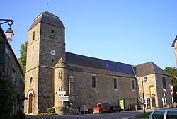
Kirche von RabodangesRabodanges ist eine französische Gemeinde mit 157 Einwohnern (Stand 1. Januar 2008) im Département Orne in der Region Basse-Normandie; sie gehört zum Arrondissement Argentan und zum Kanton Putanges-Pont-Écrepin.
Geschichte
- Der Name der Pfarrgemeinde war bis 1650 "Culley-sur-Orne"
- Der Name "Rabodanges" ist eine Abwandlung von "Rabodinghes", das im Artois bei Saint-Omer liegt. Hier war die Familie beheimatet, der auch Culley gehörte, und die sich im 15. Jahrhundert in der Normandie niederließ. König Ludwig XIV. schuf für den Herrn von Rabodanges den Titel eines "Marquis de Rabodanges". Der letzte Angehörige der Familie starb 1792.
Bevölkerungsentwicklung
- 1962 : 250
- 1968 : 217
- 1975 : 170
- 1982 : 168
- 1990 : 149
- 1999 : 157
- 2007 : 167
Ab 1962 nur Einwohner mit Erstwohnsitz
Sehenswürdigkeiten
- Das Schloss
- Der Stausee von Rabodanges
Almenêches | Anceins | Argentan | Athis-de-l’Orne | Aubry-en-Exmes | Aubry-le-Panthou | Aubusson | Aunou-le-Faucon | Avernes-Saint-Gourgon | Avernes-sous-Exmes | Avoine | Bailleul | Banvou | Batilly | Bazoches-au-Houlme | Beauchêne | Bellou-en-Houlme | Berjou | Bocquencé | Boissei-la-Lande | Boucé | Bréel | Brieux | Briouze | Cahan | Caligny | Camembert | Canapville | Cerisy-Belle-Étoile | Chambois | Champ-Haut | Champcerie | Champosoult | Chanu | Chaumont | Chênedouit | Cisai-Saint-Aubin | Clairefougère | Commeaux | Coudehard | Coulmer | Coulonces | Courménil | Couvains | Craménil | Croisilles | Crouttes | Dompierre | Durcet | Échalou | Échauffour | Écorches | Écouché | Exmes | Faverolles | Flers | Fleuré | Fontaine-les-Bassets | Fontenai-sur-Orne | Francheville | Frênes | Fresnay-le-Samson | Gacé | Gauville | Giel-Courteilles | Ginai | Glos-la-Ferrière | Goulet | Guêprei | Guerquesalles | Habloville | Heugon | Joué-du-Plain | Juvigny-sur-Orne | La Bazoque | La Bellière | La Carneille | La Chapelle-au-Moine | La Chapelle-Biche | La Cochère | La Coulonche | La Courbe | Le Fel | La Ferrière-aux-Étangs | La Ferté-Frênel | La Forêt-Auvray | La Fresnaie-Fayel | La Fresnaye-au-Sauvage | La Genevraie | La Gonfrière | La Lande-de-Lougé | La Lande-Patry | La Lande-Saint-Siméon | La Selle-la-Forge | La Trinité-des-Laitiers | Landigou | Landisacq | Larchamp | Le Bosc-Renoult | Le Bourg-Saint-Léonard | Le Château-d’Almenêches | Le Châtellier | Le Grais | Le Ménil-Ciboult | Le Ménil-de-Briouze | Le Ménil-Vicomte | Le Merlerault | Le Pin-au-Haras | Le Renouard | Le Sap | Les Authieux-du-Puits | Les Champeaux | Les Rotours | Les Tourailles | Les Yveteaux | Lignères | Lignou | Loucé | Lougé-sur-Maire | Louvières-en-Auge | Marcei | Mardilly | Marmouillé | Médavy | Ménil-Froger | Ménil-Gondouin | Ménil-Hermei | Ménil-Hubert-en-Exmes | Ménil-Hubert-sur-Orne | Ménil-Jean | Ménil-Vin | Merri | Messei | Moncy | Monnai | Mont-Ormel | Montabard | Montgaroult | Montilly-sur-Noireau | Montmerrei | Montreuil-au-Houlme | Montreuil-la-Cambe | Montsecret | Mortrée | Moulins-sur-Orne | Neauphe-sur-Dive | Nécy | Neuville-sur-Touques | Neuvy-au-Houlme | Nonant-le-Pin | Notre-Dame-du-Rocher | Occagnes | Omméel | Ommoy | Orgères | Orville | Planches | Pointel | Pontchardon | Putanges-Pont-Écrepin | Rabodanges | Rânes | Résenlieu | Ri | Roiville | Rônai | Ronfeugerai | Sai | Saint-André-de-Briouze | Saint-André-de-Messei | Saint-Aubert-sur-Orne | Saint-Aubin-de-Bonneval | Saint-Brice-sous-Rânes | Saint-Christophe-de-Chaulieu | Saint-Christophe-le-Jajolet | Saint-Cornier-des-Landes | Saint-Evroult-de-Montfort | Saint-Evroult-Notre-Dame-du-Bois | Saint-Georges-d’Annebecq | Saint-Georges-des-Groseillers | Saint-Germain-d’Aunay | Saint-Germain-de-Clairefeuille | Saint-Gervais-des-Sablons | Saint-Hilaire-de-Briouze | Saint-Jean-des-Bois | Saint-Lambert-sur-Dive | Saint-Loyer-des-Champs | Saint-Nicolas-de-Sommaire | Saint-Nicolas-des-Laitiers | Saint-Ouen-sur-Maire | Saint-Paul | Saint-Philbert-sur-Orne | Saint-Pierre-d’Entremont | Saint-Pierre-du-Regard | Saint-Pierre-la-Rivière | Saint-Quentin-les-Chardonnets | Sainte-Croix-sur-Orne | Sainte-Gauburge-Sainte-Colombe | Sainte-Honorine-la-Chardonne | Sainte-Honorine-la-Guillaume | Sainte-Opportune | Saires-la-Verrerie | Sap-André | Sarceaux | Ségrie-Fontaine | Sentilly | Serans | Sévigny | Sevrai | Silly-en-Gouffern | Survie | Taillebois | Tanques | Ticheville | Tinchebray | Touquettes | Tournai-sur-Dive | Trun | Urou-et-Crennes | Vieux-Pont | Villebadin | Villedieu-lès-Bailleul | Villers-en-Ouche | Vimoutiers | Vrigny | Yvrandes
Wikimedia Foundation.
Schlagen Sie auch in anderen Wörterbüchern nach:
Rabodanges — Saltar a navegación, búsqueda Rabodanges País … Wikipedia Español
Rabodanges — is a village and commune in the Orne département of north western France.ee also*Communes of the Orne department … Wikipedia
Rabodanges — 48° 48′ 02″ N 0° 16′ 56″ W / 48.8005555556, 0.282222222222 … Wikipédia en Français
Lac de Rabodanges — Pour voir l article sur la commune de Rabodanges, cliquez ici Lac de Rabodanges Le lac de Rabodanges … Wikipédia en Français
Stausee von Rabodanges — Geographische Lage Orne, Frankreich Zuflüsse … Deutsch Wikipedia
Les Rotours — Les Rotours … Deutsch Wikipedia
Les Rotours — 48° 46′ 51″ N 0° 15′ 39″ W / 48.7808333333, 0.260833333333 … Wikipédia en Français
Orne (fleuve) — Pour les articles homonymes, voir Orne. Orne Rabodanges (Normandie, France). La retenue d eau sur l Orne. Au premier plan à gauche, territoire de Rabodanges, à dr … Wikipédia en Français
Bazoches-au-Houlme — Pour les articles homonymes, voir Bazoches (homonymie). 48° 49′ 06″ N 0° 14′ 22″ W … Wikipédia en Français
Menil-Hermei — Ménil Hermei Ménil Hermei Administration Pays France Région Basse Normandie Département Orne Arrondissement Argentan Canton Putang … Wikipédia en Français
- Kontaktieren Sie uns: Unterstützung, Werbung
Rabodanges


18+
© Academic, 2000-2024
Wörterbücher Export, schritte mit PHP, Joomla, Drupal, WordPress, MODx.